The government has launched Sujal Gaon ID for digital mapping of rural water schemes.
Approved Jal Jeevan Mission (JJM) 2.0 extension till Dec 2028.
Increased total outlay to ₹8.69 lakh crore.
What is Sujal Gaon ID?
A unique digital ID for every rural piped water supply scheme
Enables end-to-end mapping (source → infrastructure → service area)
Integrated under “Sujalam Bharat” digital platform
Key Facts
1.64 lakh Sujal Gaon IDs created
Linked to 67,000 Sujalam Bharat IDs
Covers 31 States/UTs
Aim: Real-time monitoring, transparency, and accountability
[2024] With reference to the Digital India Land Records Modernisation Programme, consider the following statements: To implement the scheme, the Central Government provides 100% funding. Under the Scheme, Cadastral Maps are digitised. An initiative has been undertaken to transliterate the Records of Rights from local language to any of the languages recognized by the Constitution of India. Which of the statements given above are correct? (a) 1 and 2 only (b) 2 and 3 only (c) 1 and 3 only (d) 1, 2 and 3
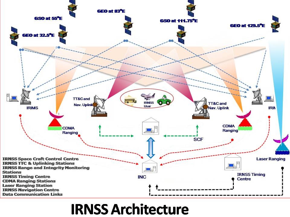
India’s indigenous navigation system NavIC has been weakened after the failure of the last atomic clock onboard the satellite IRNSS-1F. This has reduced the number of fully functional satellites to below the required minimum, affecting navigation accuracy.
What is NavIC?
Developed by ISRO.
India’s regional alternative to GPS.
Provides Position, Navigation, and Timing (PNT) services.
Coverage: India + ~1500 km beyond its borders.
Role of Atomic Clocks
Atomic clocks provide extremely precise time signals.
Navigation works by measuring time delay of signals from satellites.
Even a tiny error in time → large error in location.
Hence, clock failure = loss of navigation capability.
What has happened?
The last working atomic clock on IRNSS-1F failed (March 2026).
Many earlier NavIC satellites had already lost their clocks.
Now:
Only 3 satellites are effectively usable
Minimum 4 satellites needed for reliable navigation
Why is this a Concern?
Weakens India’s GPS Alternative: NavIC is meant as a strategic backup to systems like GPS (Global Positioning System).
Failure reduces self-reliance in critical sectors.
Strategic & Security Implications: In conflicts, access to foreign systems may be restricted or denied.
Weak NavIC leads to vulnerability in defence navigation.
Impact on Civil Applications:
Transport and logistics
Disaster management
Timing systems (banking, telecom)
Causes of the Problem
Heavy reliance on imported atomic clocks (from foreign suppliers).
Earlier multiple clock failures across satellites.
Steps Taken by India
Indigenous Atomic Clocks: New satellites use indigenously developed rubidium atomic clocks. Example: NVS-01
Replacement Satellites: ISRO plans to launch at least 3 new satellites by 2026.
[2018] With reference to the Indian Regional Navigation Satellite System (IRNSS), consider the following statements: IRNSS has three satellites in geostationary and four satellites in geosynchronous orbits. IRNSS covers entire India and about 5500 sq. km beyond its borders. India will have its own satellite navigation system with full global coverage by the middle of 2019. Select the correct answer using the code given below: (a) 1 only (b) 1 and 2 only (c) 2 and 3 only (d) None
Amid the ongoing Iran–US-Israel conflict (2026), major Gulf producers like Qatar, Kuwait, and Bahrain have invoked force majeure on oil and gas exports due to shipping disruptions and attacks on infrastructure.
What is Force Majeure?
Force majeure is a contractual clause that allows a party to suspend or cancel its obligations without penalty when extraordinary events make performance impossible.
Origin: French term meaning “superior force”
Common in international trade, energy contracts, and maritime law
Examples of Force Majeure Events
Wars and armed conflicts
Natural disasters (earthquakes, floods)
Pandemics (e.g., COVID-19)
Government actions or sanctions
[2024] Consider the following statements: Statement-I: Sumed pipeline is a strategic route for Persian Gulf oil and natural gas shipments to Europe. Statement-II: Sumed pipeline connects the Red Sea with the Mediterranean Sea. Which one of the following is correct in respect of the above statements? (a) Both Statement-I and Statement-II are correct and Statement-II explains Statement-I (b) Both Statement-I and Statement-II are correct, but Statement-II does not explain Statement-I (c) Statement-I is correct, but Statement-II is incorrect (d) Statement-I is incorrect, but Statement-II is correct
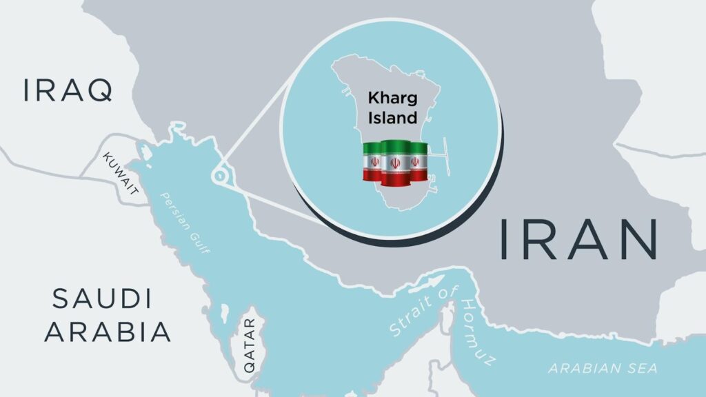
The United States launched airstrikes on military targets on Kharg Island during the ongoing US–Israel conflict with Iran. Although oil infrastructure was not targeted, the attack raises fears of disruption in global oil supply and a potential spike in crude prices.
What is Kharg Island?
A small 8-km-long coral island in the Persian Gulf.
Located about 50 km off Iran’s mainland coast.
Serves as Iran’s primary oil export hub.
Why Kharg Island is Strategically Important
Iran’s Main Oil Export Terminal: About 90% of Iran’s crude oil exports pass through Kharg Island. Pipelines from major Iranian oil fields terminate here before exports.
Massive Oil Infrastructure: Key facilities on the island include:
Falat Iran Oil Company producing around 500,000 barrels per day.
Kharg Petrochemical Company.
Large oil storage and LNG shipping facilities.
Suitable Geography for Large Tankers: Much of Iran’s coastline is too shallow for very large crude carriers (VLCCs). Kharg lies near deep waters, allowing large oil tankers to dock easily.
Oil Trade Through Kharg
Normally ≈1.5 million barrels of oil per day exported through the island.
Iran reportedly increased exports to ≈3 million barrels/day before the strike anticipating conflict.
About 18 million barrels of oil stored there as reserve capacity.
Why the Attack Matters
Impact on Oil Prices: If Kharg’s oil infrastructure were destroyed, 90% of Iran’s exports could stop. Global crude prices could surge towards $150 per barrel.
Strategic Signalling: The U.S. targeted military sites but avoided oil infrastructure, possibly to:
Avoid a major global energy shock.
Signal restraint while warning Iran against disrupting shipping.
Risk to Shipping Routes: The U.S. Navy plans to escort oil tankers through the Strait of Hormuz, which carries a large share of global oil trade.
[2012] To meet its rapidly growing energy demand, some opine that India should pursue research and development on thorium as the future fuel of nuclear energy. In this context, what advantage does thorium hold over uranium? Thorium is far more abundant in nature than uranium. On the basis of per unit mass of mined mineral, thorium can generate more energy compared to natural uranium. Thorium produces less harmful waste compared to uranium. Select the correct answer using the code given below: (a) 1 only (b) 2 and 3 only (c) 1 and 3 only (d) 1, 2 and 3
Experts have highlighted the importance of thorium-based nuclear energy in achieving India’s target of 100 gigawatts electric (GWe) nuclear power capacity by 2047, especially after the passage of the SHANTI Act 2025.
Why Thorium is Important for India
1. Largest Thorium Reserves
India possesses the world’s largest thorium reserves.
Thorium deposits are mainly found in monazite sands along the Indian coastline.
2. Energy Security
India’s current nuclear programme relies heavily on imported uranium because domestic uranium ores are low-grade.
A nuclear capacity of 100 GWe would require 18,000–20,000 tonnes of uranium annually, which may become difficult to secure globally.
3. Reduced Nuclear Proliferation Risk
Thorium fuel cycles produce less weapons-usable material, reducing proliferation risks compared to conventional uranium cycles.
India’s Three-Stage Nuclear Power Programme
The programme was designed to use India’s large thorium resources.
Stage 1: Thermal Reactors
Pressurised Heavy Water Reactor
Uses natural uranium as fuel.
Stage 2: Fast Breeder Reactors (FBRs)
Convert plutonium and fertile materials into more fuel.
India’s Prototype Fast Breeder Reactor (500 MWe) is nearing completion.
Stage 3: Thorium-Based Reactors
Thorium is converted into uranium-233, which becomes the main fuel.
Key Technologies for Thorium Deployment
Fast Breeder Reactors: Essential to generate uranium-233 from thorium.
Thorium Molten Salt Reactors (TMSR): Advanced reactors designed for thorium fuel cycles.
Small Modular Reactors (SMRs): Compact reactors that can produce electricity and green hydrogen.
HALEU Fuel: High-Assay Low-Enriched Uranium
Can be combined with thorium in existing reactors to accelerate the thorium fuel cycle.
Role of Nuclear Fuel Recycling
Nuclear recycling can increase the energy potential of fuel 50–100 times.
Countries such as France, Russia, and India already use such technologies
[2012] To meet its rapidly growing energy demand, some opine that India should pursue research and development on thorium as the future fuel of nuclear energy. In this context, what advantage does thorium hold over uranium? Thorium is far more abundant in nature than uranium. On the basis of per unit mass of mined mineral, thorium can generate more energy compared to natural uranium. Thorium produces less harmful waste compared to uranium. Select the correct answer using the code given below: (a) 1 only (b) 2 and 3 only (c) 1 and 3 only (d) 1, 2 and 3
The Government of India has introduced calibrated changes to its Foreign Direct Investment (FDI) policy for Land Bordering Countries (LBCs) to boost investment in key manufacturing sectors such as electronics components and rare earth magnets.
Background: Press Note 3 (PN3) – 2020
In April 2020, India introduced Press Note 3 (2020).
It mandated prior government approval for investments from countries sharing land borders with India.
Countries Covered
China
Pakistan
Bangladesh
Nepal
Myanmar
Bhutan
Afghanistan
Reason: Prevent opportunistic takeovers of Indian companies during the COVID-19 economic slowdown, particularly by Chinese investors.
Key Changes in the FDI Policy (2026)
Automatic Route for Small Indirect Ownership: Investments will be allowed under the automatic route if beneficial ownership from LBCs is below 10%.
This mainly benefits global private equity and venture capital funds with minor Chinese stakes.
Faster Approval Process: Investment proposals from LBCs in certain sectors must now be processed within 60 days.
Investment in “Specified Sectors”: Allowed sectors include:
Electronic components manufacturing
Electronic capital goods
Polysilicon and wafer manufacturing
Advanced battery components
Rare earth magnets and processing.
However, these investments must ensure Indian majority ownership (at least 51%).
Pakistan Exception: Investments from Pakistan will continue to require government approval and remain restricted.
Why the Policy Was Relaxed
The change follows recommendations from: NITI Aayog and Economic Survey 2023-24.
These reports argued that Chinese capital and technology could help India strengthen export competitiveness, particularly in electronics manufacturing.
Who Benefits?
Global Investment Funds: Funds like private equity and venture capital firms with minor Chinese ownership can invest without lengthy approvals.
Manufacturing Sector: Industries that depend on imported inputs such as: Electronics components, Rare earth magnets, and Semiconductor materials.
Indian Firms: Joint ventures with foreign companies while maintaining majority Indian control.
[2021] Consider the following: Foreign currency convertible bonds Foreign institutional investment with certain conditions Global depository receipts Non-resident external deposits Which of the above can be included in Foreign Direct Investments? (a) 1, 2 and 3 (b) 3 only (c) 2 and 4 (d) 1 and 4
Recent data from the Petroleum Planning and Analysis Cell shows that although India has over 34 crore LPG consumers, the average household consumption is only about half a cylinder per month, especially in rural areas.
Key Data Highlights
LPG Consumers in India
Total LPG consumers: ≈33.37 crore households
Connections under Pradhan Mantri Ujjwala Yojana: 10.56 crore
Growth in LPG Consumption
LPG consumption increased six-fold: 446 TMT in 1998–99 and 2,754 TMT in 2025–26
Major growth occurred during the 2000s and 2010s (8–11% annually).
A sharp rise happened in 2016–17 after the launch of PMUY.
Household Consumption Pattern
Average LPG Use per Household
Delhi (mostly urban): ~ 11.4 kg per month
Bihar (mostly rural): ~ 6.7 kg per month
Uttar Pradesh: ~ 7.7 kg per month
States with Highest LPG Consumers
Uttar Pradesh – 4.87 crore consumers (highest)
Maharashtra – 3.2 crore
West Bengal – 2.72 crore
Tamil Nadu – 2.4 crore
Bihar – 2.33 crore
Key Insight
Urban households rely almost entirely on LPG, leading to higher monthly usage.
Rural households often combine LPG with traditional fuels, resulting in lower consumption despite having connections.
[2009] With which one of the following has the B.K. Chaturvedi Committee dealt? (a) Review of Centre-States relation (b) Review of Delimitation Act (c) Tax reforms and measures to increase revenues (d) Price reforms in the oil sector
The Union Public Service Commission has revised the procedure for empanelment of State Director-General of Police (DGP). States must now obtain approval from the Supreme Court of India if there is a delay in submitting names for the DGP selection process.
Key Provisions of the New Rule
Supreme Court Approval for Delays: If a State government delays sending the list of eligible DGP-rank officers, it must seek permission or clarification from the Supreme Court before the UPSC proceeds.
Advance Submission of Names: States must send proposals to UPSC at least three months before the retirement of the incumbent DGP.
No “Acting DGP” Appointments: The Court reiterated that appointing an Acting DGP is not permitted, as per earlier judicial directions.
Exceptional Situations: Delays may be allowed only in exceptional circumstances such as: Death of the incumbent DGP, Resignation, and Premature relieving from service.
Background: DGP Appointment Process
The UPSC prepares a panel of three senior IPS officers eligible for the post of State DGP.
The State government then selects one officer from the panel to become the Head of Police Force (HoPF).
Judicial Basis
The rules stem from the landmark police reform judgment in: Prakash Singh vs Union of India (2006)
This case mandated reforms to ensure professional and politically independent policing, including a fixed tenure for DGPs and a transparent selection process.
Reason for the Change
Several States had delayed sending proposals or appointed temporary/acting DGPs, bypassing the process.
The R. Venkataramani stated that UPSC cannot condone such delays without Supreme Court approval.
Significance
Strengthens transparency and uniformity in DGP appointments.
Ensures compliance with police reforms mandated by the Supreme Court.
Prevents political manipulation or temporary appointments in top police positions.
[2016] Consider the following statements: The Chief Secretary in a State is appointed by the Governor of that State. The Chief Secretary in a State has a fixed tenure. Which of the statements given above is/are correct? (a) 1 only (b) 2 only (c) Both 1 and 2 (d) Neither 1 nor 2
The Supreme Court of India asked the Union Government to reconsider agricultural policies and encourage farmers to shift from wheat and paddy cultivation to pulses.
Key Observations by the Court
A Bench headed by Surya Kant stressed the need for agricultural diversification, particularly in North India where paddy cultivation dominates.
The Court noted that excessive cultivation of paddy may not be necessary except for export needs, and land could instead be used for pulses.
Directions to the Government
Review the policy framework to promote pulse cultivation.
Convene a meeting of stakeholders, including experts and farmer representatives.
Address issues affecting pulse farmers such as:
Lack of adequate Minimum Support Price (MSP) incentives.
Ensuring guaranteed and timely procurement of pulses.
Fixing the cost price of imported yellow peas so imports do not harm domestic producers.
Relevant ministries expected to participate include:
Ministry of Agriculture and Farmers Welfare
Ministry of Commerce and Industry
Ministry of Consumer Affairs Food and Public Distribution
Context
The case was filed by the farmers’ organisation Kisan Mahapanchayat, which sought restrictions on yellow pea imports to protect domestic pulse farmers.
Significance
Promoting pulses could:
Improve soil health through nitrogen fixation.
Reduce water-intensive paddy cultivation.
Enhance India’s nutritional security, as pulses are a major protein source.
Reduce dependence on pulse imports.
[2020] With reference to pulse production in India, consider the following statements: Black gram can be cultivated as both kharif and rabi crop. Green-gram alone accounts for nearly half of pulse production. In the last three decades, while the production of kharif pulses has increased, the production of rabi pulses has decreased. Which of the statements given above is/are correct? (a) 1 only (b) 2 and 3 only (c) 2 only (d) 1, 2 and 3
The 11th edition of Exercise LAMITIYE-2026 is being conducted from 10 to 22 March 2026 at the Seychelles Defence Academy, strengthening defence cooperation between India and Seychelles.
Key Highlights
First Tri-Services Edition
For the first time, the exercise includes personnel from: Indian Army, Indian Navy, and Indian Air Force
Conducted with the Seychelles Defence Forces.
Objective
Enhance interoperability and joint operational capability between the armed forces of both countries.
Focus on sub-conventional operations in semi-urban environments, especially relevant to United Nations Peacekeeping missions.
[2024] Which of the following statements about ‘Exercise Mitra Shakti-2023’ are correct? This was a joint military exercise between India and Bangladesh. It commenced in Aundh (Pune). Joint response during counter-terrorism operations was a goal of this operation. Indian Air Force was a part of this exercise. Select the answer using the code given below: (a) 1, 2 and 3 (b) 1 and 4 (c) 1 and 4 (d) 2, 3 and 4