💥UPSC 2026, 2027, 2028 UAP Mentorship (March Batch) + Access XFactor Notes & Microthemes PDF

Type: India Mapping

  • Wildlife Conservation Efforts

    Places in news: Keibul Lamjao National Park (KLNP)

    Note4Students

    From UPSC perspective, the following things are important:

    Prelims level: Keibul Lamjao National Park (KLNP)

    Mains level: Not Much

    Activists surrounding the Keibul Lamjao National Park (KLNP) in Manipur have now taken up the cudgels to ensure that the government does not shift the proposed heritage park from the approved site.

    Keibul Lamjao National Park (KLNP)

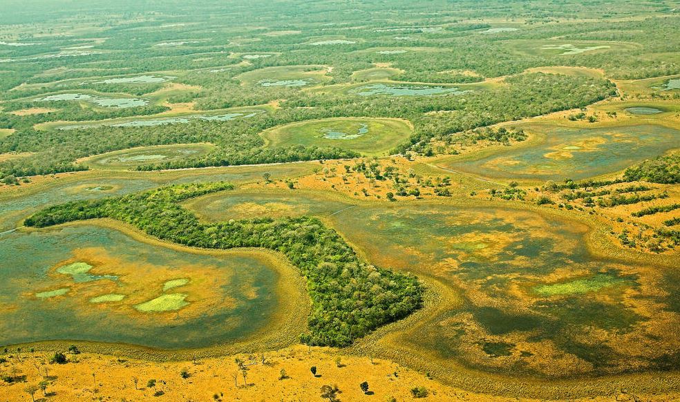
    • The KLNP is a national park in the Bishnupur district of the state of Manipur in India.
    • It is 40 km2 in area, the only floating park in the world, located in North East India, and an integral part of Loktak Lake.
    • The national park is characterized by floating decomposed plant material locally called Phumdi at the south–eastern side of the Loktak Lake, which has been declared a Ramsar site.
    • It was created in 1966 as a wildlife sanctuary to preserve the natural habitat of the endangered Eld’s deer.
    • In 1977, it was gazetted as national park.

    Key faunas

    • KLNP is home to the last of the brow-antlered deer (Rucervus eldii eldii), one of the most endangered deer in the world.
    • It is locally called as Sangai.
    • The animal is, in fact, in danger of losing its home—most of the phumdis, or floating swamps, are unable to sustain its weight.
    • In 1951, it was reported extinct, but British tea planter and naturalist Edward Pritchard Gee rediscovered it in 1953.


    UPSC 2023 countdown has begun! Get your personal guidance plan now! (Click here)

  • Foreign Policy Watch: India-Iran

    Places in news: Strait of Hormuz

    Note4Students

    From UPSC perspective, the following things are important:

    Prelims level: Strait of Hormuz

    Mains level: Global strategic flashpoints

    A US Navy warship fired a warning flare to wave off an Iranian speedboat coming straight at it during a tense encounter in the strategic Strait of Hormuz.

    Why in news?

    • The Strait of Hormuz, a narrow waterway in the Middle East marks the most sensitive transportation choke point for global oil supplies.

    Strait of Hormuz

    • The Strait of Hormuz is a narrow channel, approximately 30 miles wide at the narrowest point, between the Omani Musandam Peninsula and Iran.
    • It connects the Persian Gulf to the Gulf of Oman.
    • The Strait is deep and relatively free of maritime hazards.
    • Its depth is greatest near the Musandam Peninsula and tapers as you move north toward the Iranian shore.

    Why is it important?

    • Oil tankers carrying crude from ports on the Persian Gulf must pass through the strait.
    • Around 21 million barrels of oil a day flowed through it in 2018, equivalent to roughly a third of global seaborne oil trade and about 21% of global petroleum liquids consumption.


    UPSC 2023 countdown has begun! Get your personal guidance plan now! (Click here)

  • The Crisis In The Middle East

    Places in news: Aegean Islands

    Note4Students

    From UPSC perspective, the following things are important:

    Prelims level: Aegean Sea

    Mains level: NA

    Turkey has warned Greece to demilitarise islands in the Aegean Sea.

    What is the news?

    • Turkey says Greece has been building a military presence in violation of treaties that guarantee the unarmed status of the Aegean islands.
    • It argues the islands were ceded to Greece on the condition they remained demilitarized.

    Where is the Aegean Sea?

    • The Aegean Sea has a surface area of about 215,000 km2 and a depth of 3,544 m at the deepest end.
    • It has a maximum length of about 700 km and a width of 400 km.
    • The Bosphorus and Dardanelles Straits connect the Aegean Sea to the Black Sea and the Marmara Sea respectively.
    • The Aegean is subdivided into the Myrtoan Sea and the Thracian Sea and lies on the African and Eurasian tectonic plates’ collision path.

    Control of the region

    • The sea is situated between the Anatolia and Balkan peninsulas and lies between Turkey and Greece.
    • Nine out of 12 of Greece’s administrative regions border the sea.
    • Turkish provinces, such as Balikesir, Canakkale, Edirne, and Izmir, borders the Aegean to the east.
    • The Aegean Sea is a source of dispute and controversy between Turkey and Greece, affecting their relationship since the 1970s.

    What is the dispute?

    • Greece and Turkey are NATO allies.
    • However they have a history of disputes over a range of issues, including mineral exploration in the eastern Mediterranean and rival claims in the Aegean Sea.
    • Greece maintains Turkey has deliberately misinterpreted the treaties and says it has legal grounds to defend itself following hostile actions by Ankara.


    UPSC 2023 countdown has begun! Get your personal guidance plan now! (Click here)

  • Foreign Policy Watch: Indo-Pacific and QUAD

    Pacific Nations reject China Security Pact

    Note4Students

    From UPSC perspective, the following things are important:

    Prelims level: Pacific Nations in news

    Mains level: Chinese counter to Western Indo-Pacific strategy

    China has suffered a big diplomatic humiliation in the pacific. 10 island nations in the region rejected China’s proposed security pact.

    Why in news?

    • Chinese foreign minister Wang Yi has returned empty-handed in a highly decorated visit to the Pacific Nations.
    • The secret deal that was to be brokered got leaked in public media, caused huge embarrassment to the Chinese.

    Conspicuous features of the Pact

    • China has had offered to radically ramp up its activities in the South Pacific, directly challenging the influence of the US and its allies in the strategically vital region.
    • The failed deal saw Beijing to:
    1. Train Pacific island police,
    2. Become involved in cybersecurity,
    3. Expand political ties,
    4. Conduct sensitive marine mapping and
    5. Gain greater access to natural resources on land and in the water
    • As an enticement, Beijing is offering millions of dollars in financial aid, the prospect of a potentially lucrative China-Pacific islands free trade agreement and access to China’s vast market.

    Why Pacific Nations rejected this lollipop?

    • The offer is perceived was “disingenuous” and would “ensure Chinese influence in government” and “economic control” of key industries.
    • The nations also cited a lack of regional consensus.

    Pls make observations about Pacific Island Nations:


    UPSC 2023 countdown has begun! Get your personal guidance plan now! (Click here)

  • Roads, Highways, Cargo, Air-Cargo and Logistics infrastructure – Bharatmala, LEEP, SetuBharatam, etc.

    Places in news: Sela Tunnel

    Note4Students

    From UPSC perspective, the following things are important:

    Prelims level: Sela Pass

    Mains level: Strategic border infrastructure

    The strategically-significant Sela Tunnel project in Arunachal Pradesh is nearing completion well before the deadline.

    What is Sela Tunnel Project?

    • The Sela Tunnel is the longest bi-lane road tunnel in the world.
    • The total length of the project, including the tunnels, the approach and the link roads, will be around 12 km.
    • The tunnel is being constructed by the Border Roads Organisation at an altitude of 13,800ft near the Indo-China border.
    • It is being built on the 317km long Balipara-Charduar-Tawang (BCT) road which connects West Kameng, East Kameng and Tawang districts of Arunachal Pradesh to the rest of the country.

    Why is the project important?

    • All-weather connectivity to Tawang and other forward areas in the sector will be the most important advantage that the project promises.
    • At the moment, Sela pass stays closed for a few winter months.
    • The project will provide a new alignment on the axis towards the LAC, and allow movement of military and civil vehicles all through the year.

    Significance of the tunnel

    • China is undertaking massive infrastructure development and troop build-up in the Rest of Arunachal Pradesh (RALP) area.
    • In military parlance, the RALP is an area in Arunachal Pradesh other than the Kameng area.
    • Other than the Kameng area consisting of East and West Kameng districts, the rest of the State is referred to by the Army as the RALP.


    UPSC 2023 countdown has begun! Get your personal guidance plan now! (Click here)

  • Tiger Conservation Efforts – Project Tiger, etc.

    Ramgarh Vishdhari notified as India’s 52nd Tiger Reserve

    Note4Students

    From UPSC perspective, the following things are important:

    Prelims level: Ramgarh Vishdhari TR

    Mains level: Tiger Conservation

    Ramgarh Vishdhari Wildlife Sanctuary is now notified as a tiger reserve after a nod by the Union Ministry of Environment, Forest and Climate Change (MoEF&CC).

    Ramgarh Vishdhari TR

    • Ramgarh Vishadhri, located mostly in Bundi district and in part in Bhilwara and Kota districts.
    • It is also home to the Indian wolf, leopard, striped hyena, chinkara, antelope and foxes among other animals.
    • It is now India’s 52nd tiger reserve and Rajasthan’s fourth, after Ranthambore, Sariska and Mukundra.
    • The reserve will be spread in an area of 1,501.89 sq km.
    • The area has been called ‘critical’ for the movement of tigers by wildlife experts and conservationists.
    • Though the tiger population in Ramgarh itself was not high, it plays an important role in connecting the Ranthambore and Mukundra Tiger Reserves of Rajasthan.

    Back2Basics: Tiger Reserves

    • The Tiger Reserves of India were set up in 1973 and are governed by Project Tiger, which is administrated by the National Tiger Conservation Authority.
    • A National Park or Wildlife Sanctuary that is considered significant for protecting tigers can be additionally designated as a Tiger Reserve.
    • A Tiger Reserve consists of a ‘Core’ or ‘Critical Tiger Habitat’, which is to be managed as an inviolate area, and a ‘Buffer’ or Peripheral area immediately abutting a Core area, which may be accorded a lesser degree of habitat protection.
    • This is the typical zonation of a Tiger Reserve.


    UPSC 2023 countdown has begun! Get your personal guidance plan now! (Click here)

  • Wetland Conservation

    Places in news: Pantanal Wetlands

    Note4Students

    From UPSC perspective, the following things are important:

    Prelims level: Pantanal Wetlands

    Mains level: Not Much

    The world’s largest wetland, the Pantanal in South America, is at the risk of collapse due to legal land-use decisions and proposals.

    About Pantanal

    • The Pantanal is a natural region encompassing the world’s largest tropical wetland area, and the world’s largest flooded grasslands.
    • It is located mostly within the Brazilian state of Mato Grosso do Sul, but it extends into Mato Grosso and portions of Bolivia and Paraguay.
    • It sprawls over an area estimated at between 140,000 and 195,000 square kilometres.
    • Various subregional ecosystems exist, each with distinct hydrological, geological and ecological characteristics; up to 12 of them have been defined.
    • Roughly 80% of the Pantanal floodplains are submerged during the rainy seasons, nurturing a biologically diverse collection of aquatic plants and helping to support a dense array of animal species.

    Significance of Pantanal

    • The Pantanal is a refuge for iconic wildlife. This massive wetland has the largest concentration of crocodiles in the world, with approximately 10 million caimans.
    • Jaguars, the largest feline in the Americas, hunt caiman in the Pantanal, which has one of the highest density of jaguars anywhere the world.

    Threats

    • Around 95% of the Pantanal is under private ownership, the majority of which is used for cattle grazing.


    UPSC 2023 countdown has begun! Get your personal guidance plan now! (Click here)

  • Russian Invasion of Ukraine: Global Implications

    Places in news: Kuril Islands

    Note4Students

    From UPSC perspective, the following things are important:

    Prelims level: Kuril Islands

    Mains level: Not Much

    Japan has recently described the Kuril Islands (which Japan calls the Northern Territories and Russia as the South Kurils) as being under Russia’s “illegal occupation”.

    Note the Islands of Japan in North to South Direction:  Hokkaido, Honshu , Shikoku, and Kyushu

    What are the Kuril Islands/ Northern Territories?

    • These are a set of four islands situated between the Sea of Okhotsk and the Pacific Ocean near the north of Japan’s northernmost prefecture, Hokkaido.
    • Both Moscow and Tokyo claim sovereignty over them though the islands have been under Russian control since the end of World War II.
    • The Soviet Union had seized the islands at the end of World War II and by 1949 had expelled its Japanese residents.
    • Tokyo claims that the disputed islands have been part of Japan since the early 19th century.

    Why in news?

    • This is the first time in about two decades that Japan has used this phrase to describe the dispute over the Kuril Islands.
    • Japan had been using softer language since 2003, saying that the dispute over the islands was the greatest concern in Russia-Japan bilateral ties.

    What lies behind the dispute?

    • Japan’s sovereignty over the islands is confirmed by several treaties since 1855.
    • Russia, on the other hand, claims the Yalta Agreement (1945) and the Potsdam Declaration (1945) as proof of its sovereignty.
    • It argues that the San Francisco Treaty of 1951 is legal evidence that Japan had acknowledged Russian sovereignty over the islands.
    • Under Article 2 of the treaty, Japan had “renounced all right, title and claim to the Kuril Islands.”
    • However, Japan argues that the San Francisco Treaty cannot be used here as the Soviet Union never signed the peace treaty.

    Continuing the WW2

    • In fact, Japan and Russia are technically still at war because they have not signed a peace treaty after World War II.
    • In 1956, during Japanese PM Ichiro Hatoyama’s visit to the Soviet Union, it was suggested that two of the four islands would be returned to Japan once a peace treaty was signed.
    • However, persisting differences prevented the signing of a peace treaty though the two countries signed the Japan-Soviet Joint Declaration, which restored diplomatic relations between the two nations.
    • The Soviet Union later hardened its position, even refusing to recognise that a territorial dispute existed with Japan.
    • It was only in 1991 during Mikhail Gorbachev’s visit to Japan that the USSR recognised that the islands were the subject of a territorial dispute.

    Have there been attempts at resolution?

    • Since 1991, there have been many attempts to resolve the dispute and sign a peace treaty.
    • The most recent attempt was under PM Shinzo Abe when joint economic development of the disputed islands was explored.
    • In fact, both countries had agreed to have bilateral negotiations based on the 1956 Japan-Soviet Joint Declaration.
    • Russia was even willing to give back two islands, the Shikotan Island and the Habomai islets, to Japan after the conclusion of a peace treaty as per the 1956 declaration.
    • Japan’s attempt to improve ties with Russia was driven by its need to diversify energy sources and Russia by its need to diversify its basket of buyers and bring in foreign investments.
    • But nationalist sentiments on both sides prevented resolution of the dispute.

    Implications for Japan

    • Soon after the Russian invasion of Ukraine, Japan made its unhappiness with Russia clear.
    • Japan has been among the most steadfast of Western allies in denouncing Russian aggression and punishing it with sanctions.
    • Japan has probably been spurred by its fears of a Russia-China alliance as Japan itself has territorial disputes and an uneasy history with China.
    • Secondly, Japan might have felt that this is a good opportunity to further isolate Russia and paint it as a “habitual offender” of international law.
    • Finally, Tokyo might have been prompted to take this position as it feels that the invasion of Ukraine proves that getting back the Kuril Islands is a lost cause.


    UPSC 2023 countdown has begun! Get your personal guidance plan now! (Click here)

  • Modern Indian History-Events and Personalities

    Places in news: East Timor

    Note4Students

    From UPSC perspective, the following things are important:

    Prelims level: East Timor

    Mains level: NA

    Asia’s youngest nation, East Timor, also known as Timor Leste, holds the second and final round of its presidential election.

    About East Timor

    • The territory was colonized by Portugal in the 18th century and remained under is control until 1975.
    • When the Portuguese withdrew, troops from Indonesia invaded and annexed East Timor as its 27th province.
    • A long and bloody struggle for independence ensued, during which at least 100,000 people died.
    • The East Timorese voted for independence in a 1999 U.N.-supervised referendum, but that unleashed even more violence until peace-keeping forces were allowed to enter.
    • The country was officially recognized by the United Nations in 2002.
    • East Timor has applied to be a member of the Association of Southeast Asian Nations (ASEAN). It currently holds observer status.

    Its geography

    • East Timor comprises the eastern half of Timor Island, the western half of which is part of Indonesia.
    • It spans a 15,000 square km (5,792 square mile) land area – slightly smaller than Israel – and it’s 1.3 million people are predominantly Roman Catholic.

    Politics and economy

    • In nearly 20 years since independence, East Timor’s presidential and parliamentary elections have been dominated by many of the same faces.
    • Its revolutionary have run for and held various positions of power and continue to feature prominently in the running of the country.
    • East Timor depends on revenues from its offshore oil and gas reserves which account for 90% of its gross domestic product.
    • Its main revenue stream, the Bayu Undan gas field, is set to dry up by 2023 and the country is now planning to collaborate with companies like Australia’s Santos to turn it into carbon capture facilities.


    UPSC 2022 countdown has begun! Get your personal guidance plan now! (Click here)

  • Oil and Gas Sector – HELP, Open Acreage Policy, etc.

    Places in news: Gulf of Gabes

    Note4Students

    From UPSC perspective, the following things are important:

    Prelims level: Gulf of Gabes

    Mains level: Not Much

    A Fuel Ship with 750 tons of diesel sinks off the Gulf Of Gabes in Tunisia.

    Gulf of Gabes

    • The Gulf of Gabes also known as Lesser Syrtis contrasting with the Greater Syrtis in Libya, is a gulf on Tunisia’s east coast in the Mediterranean Sea, off North Africa.
    • The gulf roughly spans the coast from Sfax to Djerba.
    • At the head of the gulf is the city of Gabès (Ghannouche) where the tides have a large range of up to 2.1 m at spring tides.
    • Both Gabès and Sfax are major ports on the gulf, supporting sponge and tuna fisheries, with Gabès being the economic and administrative centre.
    • It is 60 miles (100 km) long and 60 miles wide and is bounded by the Qarqannah (Kerkena) Islands on the northeast and by Jarbah (Djerba) Island on the southeast.

    Regional economy of the gulf

    • Except for the Strait of Gibraltar and the Gulf of Venice, it is the only part of the Mediterranean with a substantial tidal range, causing the uncovering of extensive sandbanks at low water.
    • Sponge and tuna fisheries are located at the main ports of Qābis (Gabès) and Ṣafāqis (Sfax).
    • Oil and natural-gas deposits have been found in the gulf, east of Ṣafāqis.


    UPSC 2022 countdown has begun! Get your personal guidance plan now! (Click here)