Why in the News?
Environmentalists in Assam have proposed the Rowmari–Donduwa Wetland Complex for designation as a Ramsar Site, citing its exceptional biodiversity and ecological services.
Assam’s Wetland Context:
- Current Scenario: Assam has 3,500+ wetlands (≈1.01 lakh ha), but only Deepor Beel (2002) is a Ramsar Site.
- Conservation Importance: Designating Rowmari–Donduwa would fill a 20-year conservation gap and enhance Assam’s global wetland profile.
- Regional Context: North-East India’s Ramsar Sites- Deepor Beel (Assam), Loktak (Manipur), Rudrasagar (Tripura), Pala (Mizoram).
|
About Rowmari–Donduwa Wetland Complex:
- Overview: Situated within the Laokhowa–Burhachapori Wildlife Sanctuary, Nagaon district, Assam, forming part of the Kaziranga–Orang landscape.
- Ecological Role: An interconnected floodplain–marsh system acting as an ecological corridor between Kaziranga and Orang National Parks, supporting wildlife movement and genetic diversity.
- Biodiversity Significance: The 6th Kaziranga Wetland Bird Census (2025) recorded 47,000+ birds of 120 species, exceeding counts from Deepor Beel and Loktak Lake.
- Key Species: Hosts globally threatened birds, Knob-billed Duck, Lesser Adjutant Stork, Black-necked Stork, Ferruginous Pochard, and Common Pochard.
- Ecosystem Services: Provides flood control, groundwater recharge, carbon storage, and supports fisheries and ecotourism-based livelihoods.
- Ramsar Eligibility: Fulfils 8 of 9 Ramsar criteria, qualifying as a Wetland of International Importance.
Back2Basics: Ramsar Convention
- Establishment: Signed on 2 February 1971 in Ramsar, Iran.
- Objective: Provide a framework for conservation and wise use of wetlands and their resources.
- Functions:
- Identify and designate wetlands of international importance.
- Promote effective management of wetlands.
- Foster international cooperation for conservation.
- Members: 173 countries (as of 2025).
- India and Ramsar:
- India joined in 1982.
- First Ramsar site: Chilika Lake, Odisha (1981).
- Current total: 93 sites (Sept 2025), covering 13,60,718 hectares.
- Growth: From 26 sites in 2012 to 93 in 2025 (51 added since 2020).
- State-wise: Tamil Nadu has the highest (20), followed by Uttar Pradesh (10).
- About 10% of India’s total wetland area is under Ramsar listing.
- Montreux Record: List of Ramsar sites under threat of ecological change.
- 48 sites globally (2025).
- 2 Indian sites included: Keoladeo National Park (Rajasthan) and Loktak Lake (Manipur).
- World Wetlands Day: Celebrated on February 2nd every year.
- 2025 Theme: “Protecting Wetlands for Our Common Future”.
Criteria for Declaration (9 Criteria):
A wetland can be declared a Ramsar site if it meets at least one of these:
- Has unique, rare, or representative wetland types.
- Supports vulnerable, endangered, or endemic species.
- Provides critical habitat for waterfowl, especially during migration.
- Contains significant ecological, botanical, zoological, limnological, or hydrological features.
- Supports biodiversity conservation and scientific research.
- Provides ecosystem services like flood control, groundwater recharge, and water purification.
- Has cultural, spiritual, or recreational importance.
- Ensures sustainable livelihoods for local communities.
- Faces threats requiring international cooperation for conservation.
|
| [UPSC 2022] Consider the following pairs:
Wetland/Lake Location
1. Hokera Wetland- Punjab
2. Renuka Wetland- Himachal Pradesh
3. Rudrasagar Lake- Tripura
4. Sasthamkotta Lake- Tamil Nadu
How many pairs given above are correctly matched?
Options: (a) Only one pair (b) Only two pairs* (c) Only three pairs (d) All four pairs |
Get an IAS/IPS ranker as your 1: 1 personal mentor for UPSC 2024
Attend Now
Why in the News?
Flood discharges at Prakasam Barrage on the Krishna River has led to the closure of Bhavani Island from the mainland.
About Bhavani Island:
- Location: Situated on the Krishna River, near Vijayawada, Andhra Pradesh.
- Area: Spans ~133 acres, among India’s largest river islands.
- Management: Operated by the Andhra Pradesh Tourism Department as a major eco-tourism and recreational hub.
- Accessibility: Lies upstream of Prakasam Barrage, connected only by ferry services from the mainland.
- Ecology & Features: Rich in greenery, ponds, and meadows, offering boating, gardens, adventure parks, rural museums, and event spaces.
- Cultural Link: Named after Goddess Bhavani (Kanaka Durga); her temple atop Indrakeeladri Hill overlooks the river.
Krishna River
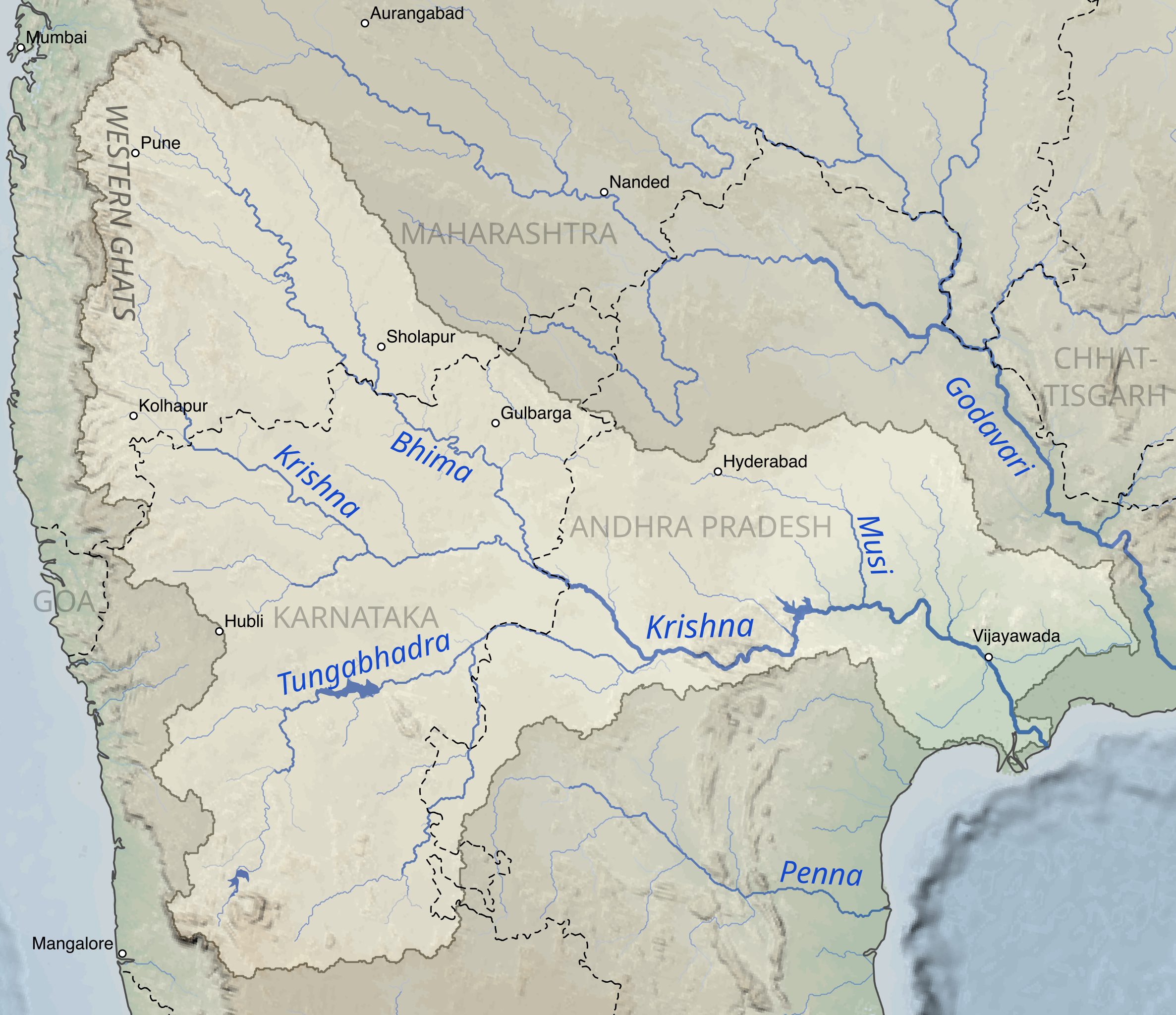
- Overview: One of India’s major peninsular rivers, stretching about 1,400 km.
- Origin & Course: Rises near Mahabaleshwar (Maharashtra), flows eastward through Karnataka, Telangana, and Andhra Pradesh, entering the Bay of Bengal at Hamsaladeevi.
- Basin Extent: Covers ~2.59 lakh sq km, nearly 8% of India’s area.
- Boundaries: Flanked by Balaghat Range (north), Eastern Ghats (east), and Western Ghats (west).
- Tributaries:
- Right Bank: Ghataprabha, Malaprabha, Tungabhadra, and Musi Rivers.
- Left Bank: Bhima, Koyna, Yerla, Panchganga, and Dudhganga Rivers.
- Projects & Dams: Major hydropower and irrigation structures including Almatti, Srisailam, Nagarjuna Sagar, Narayanpur, and Jurala.
- Prakasam Barrage: Built near Vijayawada to regulate water flow, support irrigation, navigation, and tourism.
- Economic Role: Sustains agriculture, fisheries, and power generation, forming the riverine backbone of southern India.
|
Get an IAS/IPS ranker as your 1: 1 personal mentor for UPSC 2024
Attend Now
Why in the News?
Madhya Pradesh CM has announced that Nauradehi Wildlife Sanctuary will soon become the third home for cheetahs in the State, after Kuno National Park and Gandhi Sagar Sanctuary.
About Nauradehi Wildlife Sanctuary:
- Overview: Largest wildlife sanctuary in Madhya Pradesh, covering 1,197 sq km across Sagar, Damoh, and Narsinghpur districts; located between the Narmada and Ganga river basins, forming a key ecological transition zone.
- Establishment: Declared in 1975 to conserve the Indian wolf (Canis lupus pallipes), the flagship species. Habitat includes dry deciduous forests, scrublands, and grasslands supporting leopard, sloth bear, blackbuck, nilgai, chital, and hyena populations.
- Upgradation (2024): Elevated to a Tiger Reserve to strengthen protection and become eligible for Project Cheetah under the National Tiger Conservation Authority (NTCA).
- Connectivity: Linked with Panna Tiger Reserve and Satpura Tiger Reserve through the Nauradehi–Panna corridor, ensuring gene flow across Central India’s forest landscapes.
- Habitat Characteristics: Open woodlands, scrub forests, and wide grass patches with undulating terrain ideal for high-speed pursuit predators like cheetahs.
- Prey Base: Rich in blackbuck (Antilope cervicapra), chital (Axis axis), nilgai (Boselaphus tragocamelus), and wild boar.
- Environmental Setting: Moderate rainfall, tributaries of the Narmada River, and dry tropical climate create a balanced hydrological regime.
- Scientific Endorsement: Recognised by Wildlife Institute of India (WII) and NTCA as among India’s most feasible future cheetah habitats.
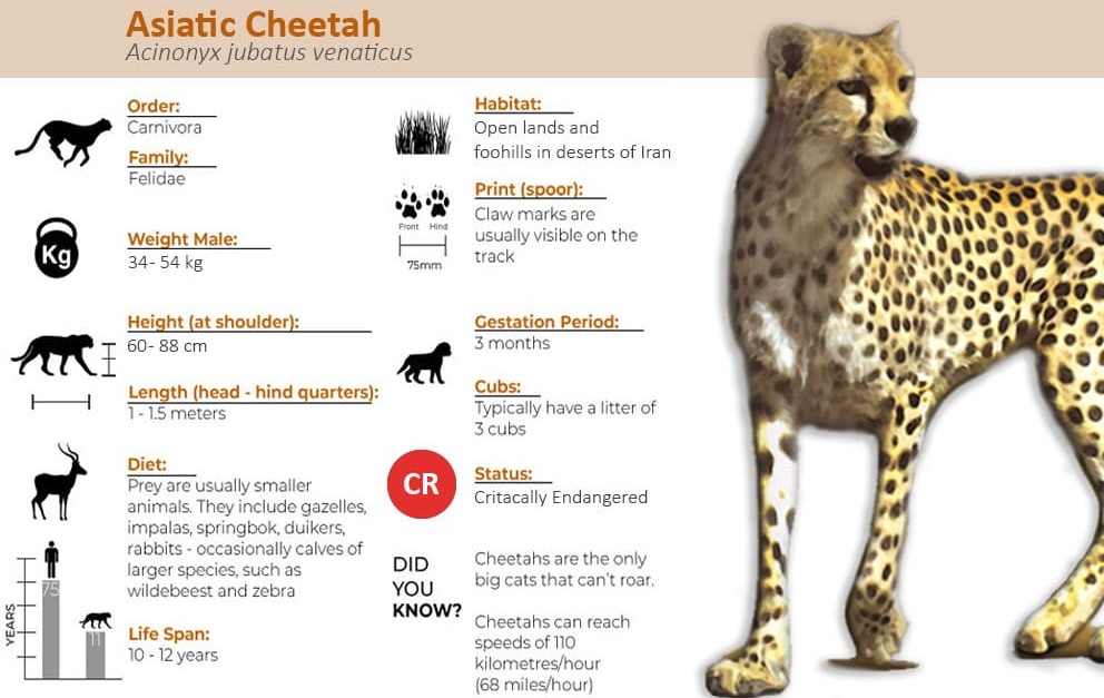
Cheetahs and their Reintroduction in India:
- Overview: The cheetah (Acinonyx jubatus) is the world’s fastest land mammal (80–128 km/h). Two subspecies: African cheetah (A.j. jubatus) across Africa and Asiatic cheetah (A.j. venaticus) confined to Iran (< 30 individuals).
- Conservation Status: Asiatic subspecies Critically Endangered by the IUCN; global population ≈ 6,500 mature individuals.
- Extinction in India: Last recorded in Koriya (Chhattisgarh) in 1947; officially declared extinct in 1952 due to hunting and grassland degradation.
- Project Cheetah (2022): Implemented by Ministry of Environment, Forest and Climate Change (MoEFCC) and NTCA with WII support; aims to restore cheetahs in India’s grasslands and revive lost ecological roles.
- Translocation Phases: Eight cheetahs from Namibia (Sept 2022) and twelve from South Africa (Feb 2023) released at Kuno National Park (Madhya Pradesh).
- Meta-Population Plan: To establish a connected population across Kuno, Gandhi Sagar, Nauradehi, and Mukundra Hills (Rajasthan) ensuring genetic diversity and landscape-level connectivity.
- Long-Term Goal: Create a self-sustaining population of 35–40 individuals within 15 years through science-based, landscape-driven restoration.
- Current Phase: Majority under semi-captive adaptation at Kuno; expansion to Nauradehi and Gandhi Sagar Tiger Reserves planned to reduce crowding and enhance resilience.
|
[UPSC 2012] Consider the following:
1. Black-necked crane 2. Cheetah 3. Flying squirrel 4. Snow leopardWhich of the above are naturally found in India?
(a) 1, 2 and 3 only (b) 1, 3 and 4 only* (c) 2 and 4 only (d) 1, 2, 3 and 4 |
Get an IAS/IPS ranker as your 1: 1 personal mentor for UPSC 2024
Attend Now
Why in the News?
A recent Nagaland University study has raised alarms over the deteriorating ecological health of Loktak Lake, India’s largest freshwater lake and a designated Ramsar Site (since 1990) in Manipur.
Key Findings of the Study:
- Core Issue: Land-use changes such as agriculture expansion, human settlements, and shifting cultivation (jhum) are deteriorating the water quality of rivers feeding the lake.
- Sampling and Rivers: Water quality analysis was done across nine major rivers draining into Loktak, linking land-use patterns with water quality indicators such as dissolved oxygen (DO), biological oxygen demand (BOD), and temperature.
- Polluted Rivers:
- Nambul River recorded the lowest oxygen levels and highest organic contamination, influenced by 47% agricultural land and 11% settlement areas in its sub-catchment.
- Khuga River had the second poorest quality due to 42% shifting cultivation (jhum).
- Iril and Thoubal Rivers, flowing through dense forested areas, showed better water quality, underscoring the protective role of forests.
About Loktak Lake:
- Overview: Situated in Manipur, about 40 km from Imphal, it is the largest freshwater lake in Northeast India.
- Unique Feature: Known for its floating biomass called phumdi (in the Meitei language), a mixture of soil, vegetation, and organic matter that supports unique aquatic life.
- Ecological Significance: The Keibul Lamjao National Park, the world’s only floating national park and habitat of the endangered brow-antlered deer (Sangai), forms an integral part of the lake ecosystem.
- Hydrology: Fed by nine major rivers, including Khuga, Western, Nambul, Imphal, Kongba, Iril, Thoubal, Heirok, and Sekmai and drained through the Ithai Barrage.
- Global Recognition:
- Declared a Ramsar Site in 1990, signifying its international ecological importance.
- Listed under the Montreux Record in 1993 for undergoing ecological degradation.
- Biodiversity: Hosts 132 plant species and 428 animal species, supporting fisheries, hydropower generation, transport, and tourism.
- Socioeconomic Role: Provides livelihoods for local communities through fishing, agriculture, and tourism while regulating floods and water supply in the Imphal valley.
| [UPSC 2015] Which of the following National Parks is unique in being a swamp with floating vegetation that supports a rich biodiversity?
Options:
(a) Bhitarkanika National Park
(b) Keibul Lamjao National Park*
(c) Keoladeo Ghana National Park
(d) Sultanpur National Park |
Get an IAS/IPS ranker as your 1: 1 personal mentor for UPSC 2024
Attend Now
Why in the News?
New satellite data in Geophysical Research Letters (October 2025) shows Iran’s Taftan volcano, dormant for 710,000 years, is reactivating.
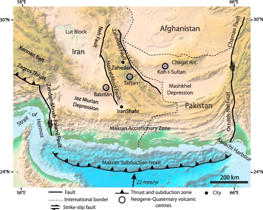
About Taftan Volcano:
- Location: Situated in southeastern Iran, about 56 km from the Pakistan border, within the Makran continental volcanic arc.
- Elevation: Rises to 3,940 metres (12,927 feet), Iran’s only active volcano in the Makran arc.
- Tectonic Origin: Formed by subduction of the Arabian oceanic plate beneath the Eurasian continental plate.
- Volcanic Type & Composition: A stratovolcano composed mainly of andesitic and dacitic lava, with pyroclastic flows and volcanic breccias.
- Structure: Features two summits, Narkuh and Matherkuh, and extensive ignimbrite and lava fans stretching over 30 km.
- Hydrothermal Activity: Hosts sulfur-emitting fumaroles, visible from up to 100 km, sustained by an active hydrothermal system.
- Eruptive History: Major activity phases around 8 Ma, 6 Ma, and 0.7 Ma; last lava flow dated to about 6,950 years ago.
- Recent Observations: 2023–24 satellite data detected 9 cm ground uplift, indicating subsurface pressure buildup and reclassification from extinct to dormant.
Scientific Interpretation and Outlook:
- Magma Dynamics: Uplift linked to gas accumulation or shallow magma intrusion at 490–630 m depth, possibly fed by deeper chambers (~3.5 km).
- Current Status: No imminent eruption expected; likely pressure release via degassing or minor eruptions.
- Monitoring Gap: Lack of ground-based GPS or seismic sensors; reliance on satellite InSAR data for deformation tracking.
- Scientific Recommendations: Call for establishing a volcano observatory in southeastern Iran for real-time monitoring and gas analysis.
- Regional Significance: Highlights Makran arc tectonic activity and underscores the need for international geophysical collaboration.
- Research Importance: Taftan’s reawakening demonstrates the role of remote sensing in detecting hidden volcanic unrest and stresses continuous monitoring to assess eruption potential and regional hazard mitigation.
[UPSC 2024] Consider the following:
1. Pyroclastic debris 2. Ash and dust 3. Nitrogen compounds 4. Sulphur compoundsHow many of the above are products of volcanic eruptions?
Options: (a) Only one (b) Only two (c) Only three (d) only four* |
Get an IAS/IPS ranker as your 1: 1 personal mentor for UPSC 2024
Attend Now
Why in the News?
The Border Roads Organisation (BRO) has achieved a historic milestone by constructing the world’s highest motorable road at Mig La Pass, situated 19,400 feet above sea level in Ladakh.
- Strategic Value: Enables rapid troop movement and logistics support in high-altitude sectors; promotes eco-tourism and local trade.
What is Project Himank?
- Overview: A flagship Border Roads Organisation (BRO) initiative launched in December 1985 to build and maintain roads in Ladakh’s high-altitude regions.
- Key Achievements: Built Umling La Road, Chisumle–Demchok, Darbuk–Shyok–DBO, Kargil–Zanskar, and now the Mig La Road (19,400 ft) under severe climatic stress.
|
About Mig La Pass:
- Importance: Crucial for India’s border logistics network, enabling swift troop deployment, supply transport, and surveillance near LAC and LoC.
- Location: Situated on the Changthang Plateau, eastern Ladakh, near the Line of Actual Control (LAC) with China.
- Elevation: Stands at 19,400 ft (5,913 m), now the highest motorable road in the world (2025), overtaking Umling La (19,024 ft).
- Alignment: Lies along the Likaru–Mig La–Fukche route, forming a third strategic link from Hanle to Fukche near the Indo-China border.
- Connectivity Role: Provides access to remote frontier villages—Hanle, Rongo, Kuyul, and Demchok—improving healthcare, communication, and supply access.
- Geography: Part of the Changthang cold desert, with thin air, permafrost, and extreme cold, posing major engineering challenges.
- Historical Link: Follows ancient Indo-Tibetan trade routes, reflecting Ladakh’s role in trans-Himalayan Silk Route exchanges.
| [UPSC 2007] Which one of the following Himalayan passes was reopened around in the middle of the year 2006 to facilitate trade between India and China?
Options: (a) Chang La (b) Jara La (c) Nathu La* (d) Shipki La |
Get an IAS/IPS ranker as your 1: 1 personal mentor for UPSC 2024
Attend Now
Why in the News?
India’s only mud volcano at Baratang Island in the Andaman and Nicobar Islands erupted after remaining dormant for over two decades.
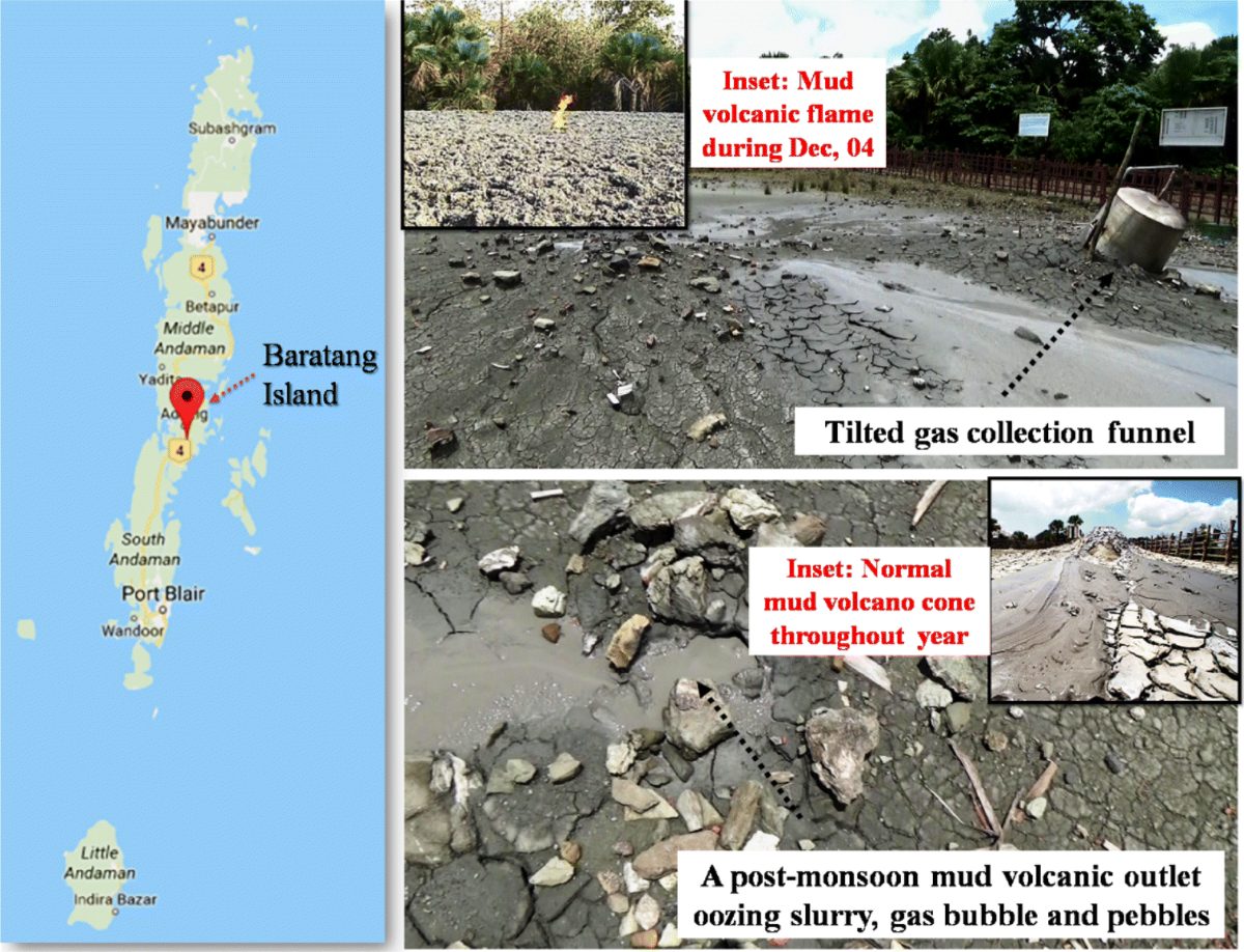
Note: The Barren Island has erupted recently.
- India’s only active lava volcano, located about 140 km from Port Blair.
- Lies at the junction of the Indian and Burmese tectonic plates.
- Eruption history: 1787 (first recorded), followed by episodes in 1991, 2005, 2017, November 2022, and September 2025.
|
About the Baratang Mud Volcano:
- Location: Baratang Island, around 100–150 km north of Port Blair, situated in the North and Middle Andaman district.
- Uniqueness: It is India’s only collection of mud volcanoes — 11 in total across the archipelago, 8 of which are on Baratang and Middle Andaman.
- Eruptions: Significant eruptions were last reported in 2005; the 2025 eruption marks the first major event in 20 years.
- Composition & Nature:
- Emits cool mud, water, and gases (methane, hydrogen sulfide) rather than lava or fire.
- Creates mud cones, bubbling pools, or dried crater-like formations.
- Eruptions are low in intensity, involving slow oozing and gas bubbling rather than violent explosions.
- Accessibility: A short 160-metre walk from the nearest road; the site lies near the Jarawa Tribal Reserve, where photography is prohibited for ethical and legal reasons.
Geological Formation and Features:
- Tectonic Setting: Formed due to subduction of the Indian Plate beneath the Burmese Plate, leading to gas and fluid release from deep layers.
- Mechanism:
- Decomposition of organic matter underground produces gas pressure that pushes mud upwards.
- These gases, along with water and sediments, escape to the surface, creating muddy eruptions and bubbling vents.
- Temperature & Composition:
- The expelled material is cool, unlike magmatic volcanoes.
- Contains saline water, organic sediments, and gases, giving it a distinctive odour and appearance.
- Earth Processes: The phenomenon helps scientists study fluid migration, methane emissions, and crustal deformation in active subduction zones.
| [UPSC 2018] Consider the following statements:
1.The Barren Island volcano is an active volcano located in the Indian territory.
2.Barren Island lies about 140 km east of Great Nicobar.
3.The last time the Barren Island volcano erupted was in 1991 and it has remained inactive since then.
Which of the statements given above is/are correct?
Options: (a) 1 only * (b) 2 and 3 (c) 3 only (d) 1 and 3 |
Get an IAS/IPS ranker as your 1: 1 personal mentor for UPSC 2024
Attend Now
Why in the News?
India has added two new wetlands in Bihar, Gokul Jalashay (Buxar district) and Udaipur Jheel (West Champaran district), to the global Ramsar list of Wetlands of International Importance.
Important Facts:
- With this, India’s Ramsar sites rise to 93, consolidating its top rank in Asia and third in the world, after the UK (176) and Mexico (144).
- Bolivia has the largest Ramsar wetland area (Llanos de Moxos wetlands – 6.9 million ha).
- India’s Ramsar sites have expanded from 26 in 2012 to 93 in 2025, covering 13.6 lakh hectares, with 51 sites added since 2020.
- Globally, there are 2,544 Ramsar sites.
|
Facts about the two Wetlands:
-
Gokul Jalashay (Buxar District):
- Oxbow lake spread over 448 hectares on the southern edge of the Ganga River.
- Acts as a flood buffer during high water events.
- Supports 50+ bird species and provides livelihoods through fishing, farming, and irrigation.
-
Udaipur Jheel (West Champaran District):
- Oxbow lake covering 319 hectares, part of the Udaipur Wildlife Sanctuary ecosystem, formed by the Gandaki River.
- Enhances ecological connectivity and supports the Central Asian Flyway for migratory birds.
About the Ramsar Convention:
- Establishment: Signed on 2 February 1971 in Ramsar, Iran.
- Objective: Provide a framework for conservation and wise use of wetlands and their resources.
- Functions:
- Identify and designate wetlands of international importance.
- Promote effective management of wetlands.
- Foster international cooperation for conservation.
- Members: 173 countries (as of 2025).
- India and Ramsar:
- India joined in 1982.
- First Ramsar site: Chilika Lake, Odisha (1981).
- Current total: 93 sites (Sept 2025), covering 13,60,718 hectares.
- Growth: From 26 sites in 2012 to 93 in 2025 (51 added since 2020).
- State-wise: Tamil Nadu has the highest (20), followed by Uttar Pradesh (10).
- About 10% of India’s total wetland area is under Ramsar listing.
- Montreux Record: List of Ramsar sites under threat of ecological change.
- 48 sites globally (2025).
- 2 Indian sites included: Keoladeo National Park (Rajasthan) and Loktak Lake (Manipur).
- World Wetlands Day: Celebrated on February 2nd every year.
- 2025 Theme: “Protecting Wetlands for Our Common Future”.
Criteria for Declaration (9 Criteria):
A wetland can be declared a Ramsar site if it meets at least one of these:
- Has unique, rare, or representative wetland types.
- Supports vulnerable, endangered, or endemic species.
- Provides critical habitat for waterfowl, especially during migration.
- Contains significant ecological, botanical, zoological, limnological, or hydrological features.
- Supports biodiversity conservation and scientific research.
- Provides ecosystem services like flood control, groundwater recharge, and water purification.
- Has cultural, spiritual, or recreational importance.
- Ensures sustainable livelihoods for local communities.
- Faces threats requiring international cooperation for conservation.
| [UPSC 2022] Consider the following pairs:
Wetland/Lake Location
1. Hokera Wetland — Punjab 2. Renuka Wetland — Himachal Pradesh
3. Rudrasagar Lake — Tripura 4. Sasthamkotta Lake — Tamil Nadu
How many pairs given above are correctly matched?
Options: (a) Only one pair (b) Only two pairs* (c) Only three pairs (d) All four pairs |
Get an IAS/IPS ranker as your 1: 1 personal mentor for UPSC 2024
Attend Now
Why in the News?
UNESCO added India’s Cold Desert Biosphere Reserve (CDBR) to the World Network of Biosphere Reserves (WNBR) under the Man and the Biosphere (MAB) programme.
With this, India now has 13 UNESCO-recognized biosphere reserves out of 18 designated nationally.
What are UNESCO Biosphere Reserves?
- Overview: Sites integrating biodiversity conservation + cultural heritage + sustainable development.
- Programme: MAB (1971).
- Designation Criteria:
- Must include a protected core zone.
- Must represent a unique biogeographical unit.
- Involve local communities in conservation.
- Potential to preserve traditional lifestyles.
- Functions: Conservation, Development, Logistic Support.
- Global Network (WNBR): 785 sites, 142 countries (2025); 7.4 million sq. km (~5% Earth’s surface); home to 275 million people.
|
About Cold Desert Biosphere Reserve (CDBR):
- Location: Lahaul–Spiti (Himachal Pradesh), part of Trans-Himalayan biogeographic province.
- Constituents: Includes Pin Valley National Park, Kibber Wildlife Sanctuary, Chandratal Wetland, Sarchu Plains.
- Biodiversity:
- Flora: 732 vascular plants, incl. 30 endemic, 47 medicinal plants (Amchi / Sowa Rigpa).
- Fauna: Snow leopard (flagship), Tibetan wolf, Himalayan ibex, blue sheep (800+ in Spiti), Himalayan snowcock, golden eagle, bearded vulture.
- Communities: ~12,000 people; practice yak & goat herding, barley/pea farming, Tibetan herbal medicine, Buddhist monastic councils.
- Significance: Boosts eco-tourism, climate research, community-led conservation, sustainable livelihoods. Supports climate-resilient development in fragile ecosystems.
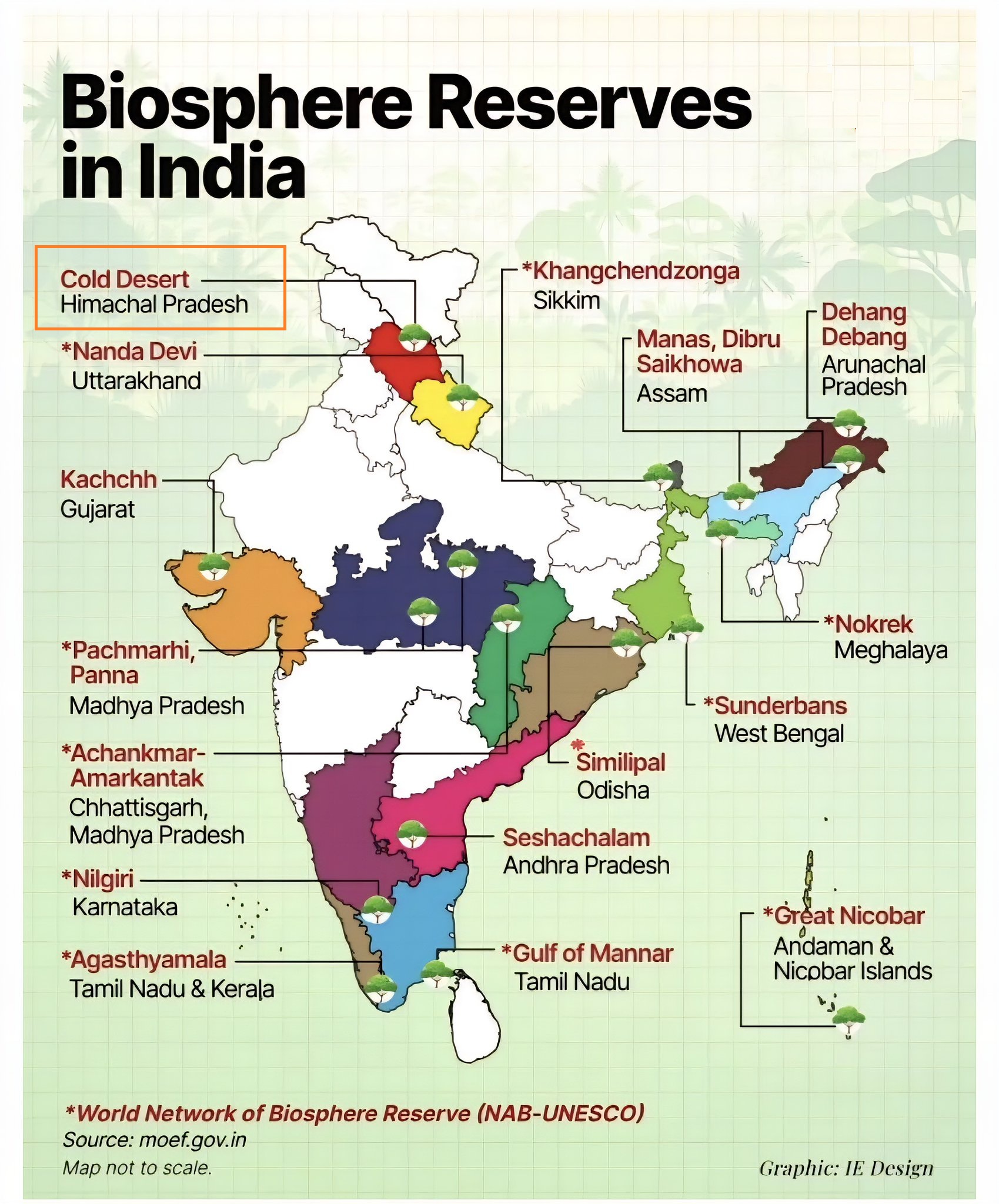
Biosphere Reserves in India:
- Total: 18 designated, of which 13 in UNESCO-WNBR (as of 2025).
- First: Nilgiri BR (1986); Largest: Gulf of Kachchh (Gujarat); Smallest: Dibru-Saikhowa (Assam).
- Scheme: Launched 1986; implemented by MoEFCC under MAB Programme.
- Three zones: Each biosphere reserve is organised into-
-
- Core zone (strictly protected),
- Buffer zone (limited human activity such as research, grazing, and tourism permitted), and
- Transition zone (sustainable human settlements and economic activities allowed).
- Funding: 90:10 (NE & Himalayan states); 60:40 (others).
| [UPSC 2019] Which of the following are in Agasthyamala Biosphere Reserve?
Options: (a) Neyyar, Peppara and Shendurney Wildlife Sanctuaries; and Kalakad Mundanthurai Tiger Reserve*
(b) Mudumalai, Sathyamangalam and Wayanad Wildlife Sanctuaries; and Silent Valley National Park
(c) Kaundinya, Gundla Brahmeswaram and Papikonda Wildlife Sanctuaries; and Mukurthi National Park
(d) Kawal and Sri Venkateswara Wildlife Sanctuaries; and Nagarjunasagar-Srisailam Tiger Reserve |
Get an IAS/IPS ranker as your 1: 1 personal mentor for UPSC 2024
Attend Now
Why in the News?
Barren Island, which is not only India’s but South Asia’s only active volcano, has erupted twice in a span of eight days.
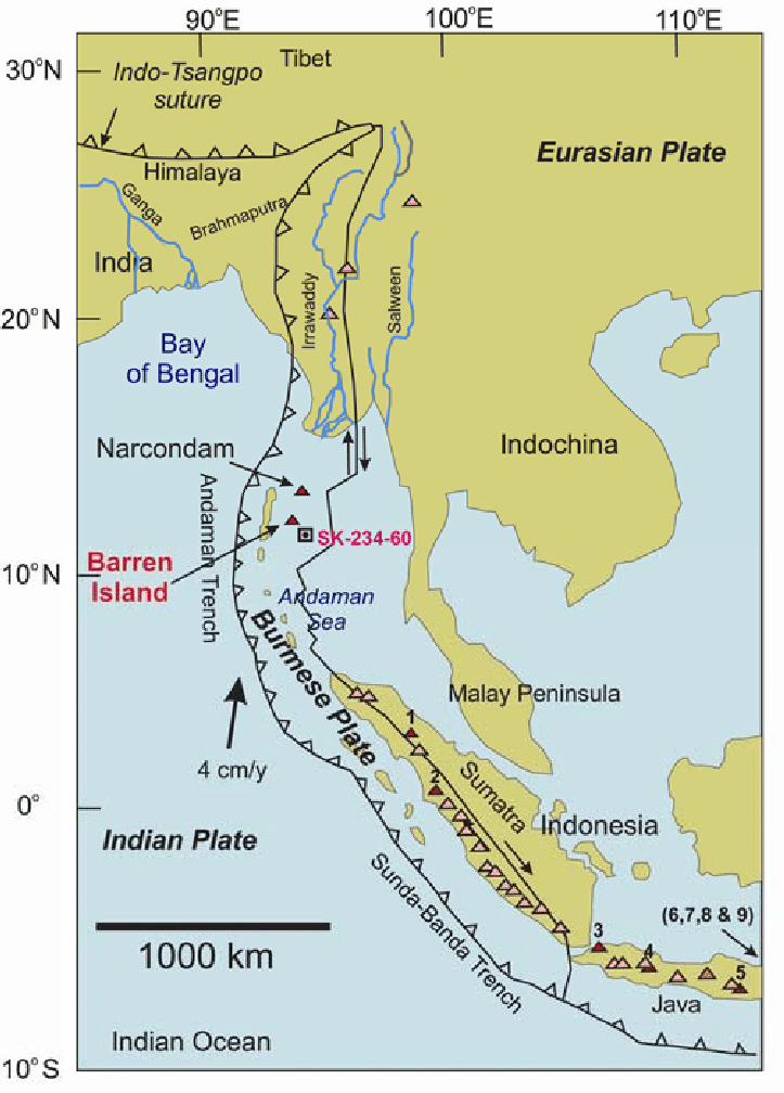
About Barren Island:
- Location: In the Andaman Sea, about 138–140 km northeast of Port Blair, within the Andaman and Nicobar Islands (India).
- Unique Status: The only confirmed active volcano in the Indian subcontinent and South Asia, lying on the volcanic arc between Sumatra (Indonesia) and Myanmar.
- Geophysical Features: Roughly circular island (~3 km diameter); volcanic crater located 0.5 km from shore, rising to 354 m above sea level and classified as a stratovolcano made of lava, volcanic ash, and rock fragments.
- Volcanic Activity
- First Recorded Eruption: 1787.
- Notable Eruptions: 1789, 1795, 1803–04, 1852, 1991, 2017, and minor eruptions in 2025.
- 1991 Eruption: Lasted ~6 months, destructive to local fauna.
- Volcanic Explosivity Index (VEI): Generally low, around 2.
- Geological Significance:
- Age of Flows: Oldest subaerial lava flows dated to 1.6 million years ago.
- Crust: Built on 106 million-year-old oceanic crust.
- Tectonics: Part of the subduction zone where the Indian Plate meets the Burmese Plate.
- Research Value: Critical for geological and volcanic studies as India’s only active volcano.
Note:
Although there are no active volcanoes in mainland India, there are some extinct and dormant volcanoes in the country. These are: Narcondam Island (dormant, A&N Islands); Deccan Plateau (18.51°N 73.43°E; extinct, Maharashtra); Baratang Island (mud volcanoes; active, A&N Islands); Dhinodhar Hills (extinct, Gujarat); Dhosi Hill (extinct, Haryana–Rajasthan border); Tosham Hills (extinct, Haryana); and Loktak Lake (Supervolcanic caldera, Manipur).
[UPSC 2018] Consider the following statements:
- The Barren Island volcano is an active volcano located in the Indian territory.
- Barren Island lies about 140 km east of Great Nicobar.
- The last time the Barren Island volcano erupted was in 1991 and it has remained inactive since then.
Which of the statements given above is/are correct?
(a) 1 only*
(b) 2 and 3
(c) 3 only
(d) 1 and 3 |
Get an IAS/IPS ranker as your 1: 1 personal mentor for UPSC 2024
Attend Now
Why in the News?
This newscard is an excerpt from a photo published in ‘The Hindu’.
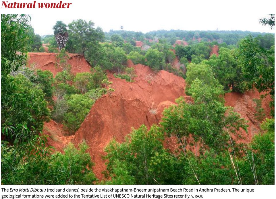
About Erra Matti Dibbalu:
- Location: Found between Visakhapatnam and Bheemunipatnam in Andhra Pradesh, stretching 5 km along the coast, with widths ranging from 200 m to 2 km.
- Meaning: In Telugu, “Erra Matti” means red soil and “Dibbalu” means mounds, describing the reddish sand dunes.
- Geological Heritage: Listed among the 34 National Geological Heritage Monument Sites of India by the Geological Survey of India (GSI).
- Formation: Created around 12,000–18,500 years ago through the combined effect of tectonic activity (2.5 million–11,000 years ago), sea-level changes, monsoonal variability, and global climatic shifts.
- Composition: Derived mainly from Khondalite rocks of the Eastern Ghats hinterland, with the red colour due to oxidation of iron-rich sediments.
Significance:
- Geological Value: Acts as a paleo-environment indicator, providing evidence of climate change, sea-level fluctuations, and coastal evolution during the late Quaternary period.
- Archaeological Importance: Artefacts from Mesolithic and Neolithic periods and sediment layers dating back to the Late Pleistocene epoch have been found here.
- Conservation Status: Declared a National Geo-heritage Monument (2016) and included in UNESCO’s Tentative List of World Heritage Sites (2025) for global recognition and protection.
- Unique Landscape: Features badland topography with sand dunes, buried channels, gullies, and dendritic drainage patterns.
- Rare Formation: Only two other similar red sand dune systems exist globally—the Teri dunes in Tamil Nadu and one site in Sri Lanka.
| [UPSC 2014] When you travel in Himalayas, you will see the following:
1. Deep gorges 2. U-turn river courses 3. Parallel mountain ranges 4. Steep gradients causing land sliding
Which of the above can be said to be the evidence for Himalayas being young fold mountains?
Options: (a) 1 and 2 only (b) 1, 2 and 4 only (c) 3 and 4 only (d) 1, 2, 3 and 4* |
Get an IAS/IPS ranker as your 1: 1 personal mentor for UPSC 2024
Attend Now
Why in the News?
The Union Environment Ministry has approved the capture and translocation of eight tigers from Tadoba-Andhari and Pench reserves to the Sahyadri Tiger Reserve (STR) in western Maharashtra.
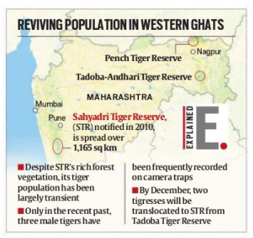
About Sahyadri Tiger Reserve (STR):
- Overview: Situated in the Sahyadri Range, Western Ghats (Maharashtra), spanning districts of Satara, Sangli, Kolhapur, Ratnagiri.
- Status: Declared Tiger Reserve (2010); part of UNESCO Western Ghats World Heritage Site (2012).
- Geography: Dominated by Shivsagar (Koyna) and Vasant Sagar (Warana) reservoirs.
- Vegetation: Moist evergreen, semi-evergreen, moist & dry deciduous forests; endemic trees like karvi, bamboo, Terminalia, Emblica.
- Fauna: Bengal tiger, leopard, dhole, gaur, antelopes, mouse deer, giant squirrel. Birds include hornbills, vultures, river tern.
- Tiger Status: Tigers absent for years; 5–9 present since 2018 (as per camera trap evidence).
- Corridor Linkages: Connected to Radhanagari WLS (north) and Anshi–Dandeli TR (south, Karnataka), forming a key Western Ghats corridor.
- Ecological Role: Secures catchments of Koyna & Warna rivers, crucial for farming and livelihoods.
Need for Tiger translocation:
- Prey base: Reserve has prey-rich habitat but lacks a stable breeding tiger population.
- Other benefits: Prevents local extinction, strengthens corridor connectivity, supports Project Tiger, conserves biodiversity, and secures river watersheds.
| [UPSC 2017] From the ecological point of view, which one of the following assumes importance in being a good link between the Eastern Ghats and the Western Ghats?
Options: (a) Sathyamangalam Tiger Reserve* (b) Nallamala Forest (c) Nagarhole National Park (d) Seshachalam Biosphere Reserve |
Get an IAS/IPS ranker as your 1: 1 personal mentor for UPSC 2024
Attend Now
Why in the News?
Sri Lankan President Dissanayake’s visit to Katchatheevu Island, the first ever visit by a head of state, revived debates on the island’s history and ownership.
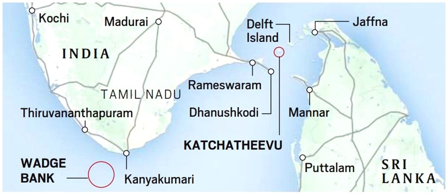
About Katchatheevu Island:
- Overview: Small uninhabited island of about 285 acres in the Palk Strait, ~33 nautical miles from Jaffna (Sri Lanka) and close to Ramanathapuram (Tamil Nadu).
- History: Once under the Raja of Ramnad (TN), later became disputed during British rule.
- Agreements: Under 1974 and 1976 pacts, India (under Indira Gandhi govt.) recognised Sri Lanka’s sovereignty and gave up traditional fishing rights.
- Religious Site: Home to St. Anthony’s Catholic Shrine, visited annually by Indian and Sri Lankan fishermen during a joint festival with visa waiver.
- Ecology: Though barren and unsettled, serves as a resting point for fishermen and supports marine biodiversity.
Disputes around Katchatheevu:
- Fishing Conflicts: Tamil Nadu fishermen often cross into Sri Lankan waters due to declining catch in Indian waters, leading to frequent arrests by the Sri Lankan Navy.
- Bottom-Trawling Issue: Indian trawlers use bottom-trawling, banned in Sri Lanka, which damages marine ecosystems and escalates tensions.
- Political Demands: All TN political parties have demanded retrieval of the island.
- National Politics: Issue often resurfaces during elections, with claims that earlier governments “easily gave away” Katchatheevu.
- Official Position: India clarified in 2013–14 that no sovereign territory was ceded since the island was disputed, not fully under India’s control.
- Core Problem: Lies not in sovereignty but in unsustainable bottom-trawling practices and the livelihood crisis faced by Tamil Nadu fishermen.
| [UPSC 2020] Consider the following statements:
1. The value of Indo-Sri Lanka trade has consistently increased in the last decade.
2. “Textile and textile articles” constitute an important item of trade between India and Bangladesh.
3. In the last five years, Nepal has been the largest trading partner of India in South Asia.
Which of the statements given above is/are correct? (2020)
Options: (a) 1 and 2 only (b) 2 only* (c) 2 only (d) 3 only |
Get an IAS/IPS ranker as your 1: 1 personal mentor for UPSC 2024
Attend Now
Why in the News?
India has rejected Nepal’s objection to resumption of India–China border trade through the Lipulekh Pass in Uttarakhand.
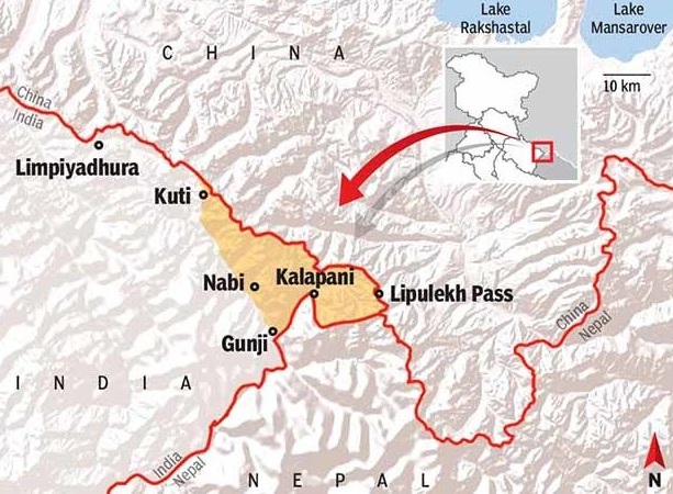
About Lipulekh Pass:
- Location: High-altitude Himalayan pass (~17,000 ft) near the trijunction of India, Nepal, and China (Tibet).
- Connectivity: Links Uttarakhand’s Kumaon region with Taklakot in Tibet.
- Cultural Role: Serves as the shortest route for the Kailash Mansarovar Yatra.
- Trade Importance: Historic India–China trade route since 1954; disrupted during COVID-19 but later resumed.
- Strategic Significance: Crucial for India due to its proximity to the India–China–Nepal border.
What is Limpiyadhura–Lipulekh–Kalapani Dispute?
- Origin: Rooted in the 1815 Treaty of Sugauli (Nepal–British East India Company), fixing Nepal’s western boundary at the Kali (Mahakali) River.
- India’s Position: Claims Kali River originates near Lipulekh, placing Lipulekh and Kalapani within India.
- Nepal’s Position: Claims Kali River originates at Limpiyadhura, extending Nepal’s boundary east to include Lipulekh and Kalapani.
- Disputed Area: About 370 sq. km., under Indian administration since the 19th century.
- Recent Development: In 2020, Nepal issued a new map showing Limpiyadhura, Lipulekh, and Kalapani as its territory; India rejected the claim citing lack of historical basis.
Back2Basics: India–Nepal Border Disputes
- Border Length: India and Nepal share a 1,770 km long open border across five Indian states – Uttarakhand, Uttar Pradesh, Bihar, West Bengal, and Sikkim.
- Key Disputes:
- Kalapani–Lipulekh–Limpiyadhura (Uttarakhand): Discussed above.
- Susta (Uttar Pradesh–Nepal border): Caused by Gandak River’s shifting course, leading to encroachments and overlapping claims.
- Tensions: Despite close ties, disputes often cause diplomatic strains.
- Positions: India relies on historical treaties and long-standing administration, while Nepal asserts sovereignty and constitutional recognition of disputed territories.
|
| [UPSC 2007] Which one of the following Himalayan passes was reopened around in the middle of the year 2006 to facilitate trade between India and China?
Options : (a) Chang La (b) Jara La (c) Nathu La* (d) Shipki La |
Get an IAS/IPS ranker as your 1: 1 personal mentor for UPSC 2024
Attend Now
Why in the News?
India’s National Security Council Secretariat recently hosted envoys from the US, UAE, Saudi Arabia, France, Italy, Germany, Israel, Jordan, and the EU to review progress on the India–Middle East–Europe Economic Corridor (IMEC).
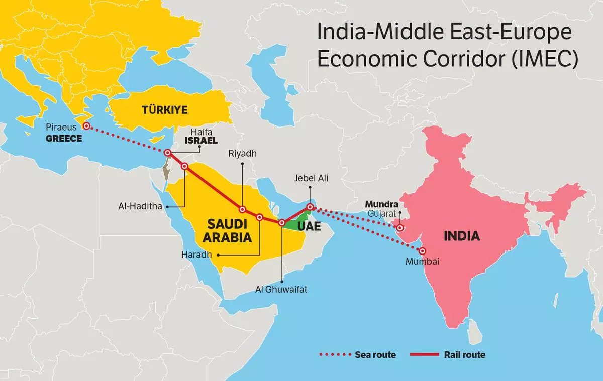
About IMEC Project:
- Part of the Partnership for Global Infrastructure and Investment (PGII) for developing connectivity in emerging regions.
- MoU signed on 10 September 2023 at the G20 New Delhi Summit.
- Members: India, US, UAE, Saudi Arabia, France, Germany, Italy, European Union.
- Aim: Integrate Asia, Middle East, and Europe to boost transport efficiency, reduce costs, create jobs, cut greenhouse gas emissions, and strengthen economic unity.
- Structure:
- East Corridor: India to Arabian Gulf.
- Northern Corridor: Gulf region to Europe.
- Key Ports:
- India – Mundra, Kandla, Jawaharlal Nehru Port (Mumbai).
- Middle East – Fujairah, Jebel Ali, Abu Dhabi, Dammam, Ras Al Khair.
- Israel – Haifa.
- Europe – Piraeus, Messina, Marseille.
- Infrastructure includes: Railway links, ship-to-rail hubs, roads, electricity cables, hydrogen pipelines, and high-speed data cables.
Impact of Gaza War:
- Derailed work: Conflict from late 2023 halted stakeholder meetings and derailed western leg (Middle East–Europe) progress.
- Jordan–Israel relations at historic low; Saudi–Israel normalisation stalled.
- Regional rivalries (e.g., Saudi–UAE trade competition) hinder unified operational planning.
Significance:
- Economic: EU is India’s largest trading partner; corridor promises faster, cheaper trade with reduced emissions.
- Strategic: Strengthens India’s role in West Asia and positions it as a connector between Europe and the Middle East.
- Energy & Technology: Potential for clean hydrogen pipelines, electricity and data cable links.
- Resilience: Provides alternative to Red Sea shipping routes vulnerable to disruptions.
| [UPSC 2025] India is one of the founding members of the International North-South Transport Corridor (INSTC), a multimodal transportation corridor, which will connect:
Options: (a) India to Central Asia to Europe via Iran* (b) India to Central Asia via China (c) India to South-East Asia through Bangladesh and Myanmar (d) India to Europe through Azerbaijan |
Get an IAS/IPS ranker as your 1: 1 personal mentor for UPSC 2024
Attend Now
Why in the News?
The Great Barrier Reef is facing its sharpest coral decline in 40 years, with the 2024 mass bleaching—driven by climate change, cyclones, and coral predators—severely damaging large reef areas.
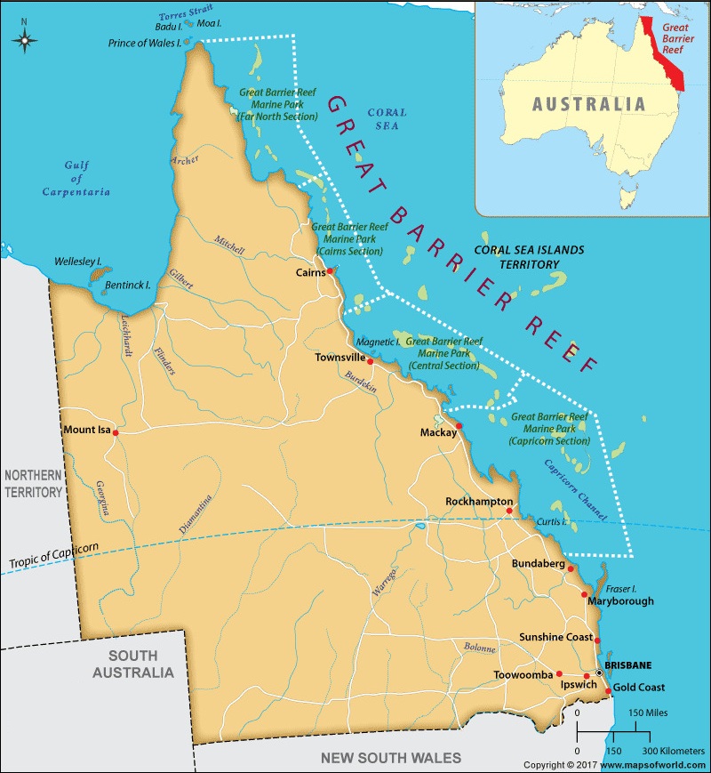
About Great Barrier Reef:
- Location: Coral Sea, off the northeast coast of Queensland, Australia.
- Length & Area: Extends ~2,300 km; comprises ~3,000 reefs and 900 islands, covering ~350,000 square kilometers (about 10% of global coral reef ecosystems).
- Biodiversity:
- Hosts 400 coral species, 1,500 fish species, and 4,000 mollusk species.
- Habitat for endangered species like the dugong and green turtle.
- Reef Types: Includes platform reefs, wall reefs, and fringing reefs.
- Protection Status:
- Managed by the Great Barrier Reef Marine Park Authority.
- Declared a United Nations Educational, Scientific and Cultural Organization (UNESCO) World Heritage Site in 1981.
- Mass Bleaching Years: Notable events occurred in 1998, 2002, 2016, 2017, 2020, 2022, 2024, and 2025.
Coral Decline and Bleaching Events:
- Main Cause: Heat stress due to climate change, particularly during marine heatwaves.
- 2024 Event: Fifth major bleaching since 2016; had the widest spatial impact recorded in the Australian Institute of Marine Science’s 39-year monitoring program.
- Additional Damage: Cyclones (e.g., Cyclone Jasper) and flood plumes caused physical damage and freshwater stress.
- Biological Threats: Crown-of-thorns starfish (COTS) outbreaks intensified coral predation, especially in the Swains sector.
- 2025 Survey Findings:
- 48% of 124 surveyed reefs showed coral decline.
- Only 10% recorded an increase in coral cover.
- Regional Impact: Southern Great Barrier Reef saw a 30.6% drop in hard coral cover—the sharpest annual decline ever recorded in that zone.
| [UPSC 2014] The scientific view is that the increase in global temperature should not exceed 2 0 C above pre-industrial level. If the global temperature increases beyond 30 C above the pre-industrial level, what can be its possible impact/impacts on the world?
1. Terrestrial biosphere tends toward a net carbon source. 2. Widespread coral mortality will occur. 3. All the global wetlands will permanently disappear. 4. Cultivation of cereals will not be possible anywhere in the world. Select the correct answer using the code given below:
Options: (a) 1 only (b) 1 and 2 only* (c) 2, 3 and 4 only (d) 1, 2, 3 and 4 only |
Get an IAS/IPS ranker as your 1: 1 personal mentor for UPSC 2024
Attend Now
Why in the News?
The proposal to expand the Sundarbans Tiger Reserve by 1,100 sq km has received clearance from the National Tiger Conservation Authority (NTCA) and awaits approval from National Board for Wildlife (NBWL).

About Sundarbans Tiger Reserve (STR):
- Location: Situated in South and North 24-Parganas districts, West Bengal; lies at the southern tip of the Gangetic Delta.
- Area: Presently 2,585.89 sq km; expansion to 3,629.57 sq km under proposal.
- Status: Notified as a Tiger Reserve, National Park, Biosphere Reserve; part of the UNESCO World Heritage Site.
- Unique Feature: World’s only mangrove forest with a viable tiger population.
- Tiger Count: Over 100 tigers – 80 in core area, 21 in adjoining forests.
- Landscape: Interconnected estuaries, tidal creeks, and 105 mangrove-covered islands.
- Flora: Dominated by mangrove species like Avicennia, Rhizophora, Heritiera.
- Fauna: Includes Royal Bengal Tigers, Fishing Cats, Estuarine Crocodiles, Irrawaddy Dolphins, King Cobras, and endangered reptiles and birds.
- Boundaries:
- East: Bangladesh border (Raimangal, Harinbhanga rivers)
- South: Bay of Bengal
- North/West: Matla, Bidya, Gomdi Rivers
Back2Basics: Tiger Reserves in India
- Overview: A Tiger Reserve is a legally notified area under the Wildlife (Protection) Act, 1972 for the conservation of tigers and biodiversity.
- Governing Authority: National Tiger Conservation Authority (NTCA), Ministry of Environment, Forest and Climate Change.
- Origin: Initiated under Project Tiger, launched in 1973.
- Structure:
- Core Zone: Highly protected; no human activity allowed; declared as National Park or Sanctuary.
- Buffer Zone: Surrounds core; allows regulated human use and supports conservation-compatible livelihoods.
Tiger Reserve Landscape in India (as of 2025):
- Total Reserves: 58 (up from 46 in 2014)
- Largest Reserve: Nagarjunasagar-Srisailam, Andhra Pradesh – 3,727.82 sq km
- Oldest Reserve: Corbett Tiger Reserve, Uttarakhand – established in 1973
- Newest Reserves: Guru Ghasidas (Chhattisgarh), Ranipur (Uttar Pradesh), Ramgarh Vishdhari (Rajasthan)
- Top State: Madhya Pradesh – 7 Tiger Reserves
- Tiger Density: Bandipur TR > Corbett TR > Kaziranga TR (148, 18.6 tigers/sq. km.)
- Global Tiger Day: Celebrated on 29th July every year
|
| [UPSC 2020] Among the following Tiger Reserves, which one has the largest area under “Critical Tiger Habitat”?”
Options: (a) Corbett (b) Ranthambore (c) Nagarjunsagar-Srisailam* (d) Sunderbans |
Get an IAS/IPS ranker as your 1: 1 personal mentor for UPSC 2024
Attend Now
Why in the News?
As India marks Jim Corbett’s 150th birth anniversary (1875–2025), it reflects on his legacy as a hunter, naturalist, author, and conservationist—after whom Corbett National Park is named.

Who was Jim Corbett?
- Full Name: Edward James Corbett (1875–1955), nicknamed Carpet Sahib in Kumaon.
- Profession: British hunter, naturalist, author, and later a wildlife conservationist.
- Famous Books: Man-Eaters of Kumaon, The Man-Eating Leopard of Rudraprayag, My India, Jungle Lore, Tree Tops.
- Hunter Turned Hero:
- Known for tracking and killing man-eating tigers and leopards in Kumaon and Garhwal.
- Used patient observation and deep knowledge of terrain and animal behaviour.
- Shift to Conservation:
- Grew concerned about dwindling tiger numbers and deforestation.
- Advocated for wildlife protection and ecological balance.
- Commemoration: India’s first national park was renamed Jim Corbett National Park in 1957 in his honour.
Back2Basics: Jim Corbett National Park
- Established: 1936 as Hailey National Park; later renamed in 1957.
- Location: Nainital district, Uttarakhand; core of Corbett Tiger Reserve.
- Historical Importance:
- Launch site of Project Tiger in 1973, India’s flagship tiger conservation programme.
- Geography:
- Lies in Shivalik and Outer Himalayan foothills.
- Rivers: Ramganga, Sonanadi, Mandal, Palain, and Kosi.
- Area: Over 500 sq km (includes Sonanadi Wildlife Sanctuary as buffer).
- Biodiversity:
- Flora: Moist deciduous forest with Sal, Khair, and Sissoo; 600+ plant species.
- Fauna: Over 230 tigers (highest density in the world), elephants, leopards, deer (sambar, chital, barking), sloth bears, wild boars, birds, and reptiles.
|
| [UPSC 2013] Consider the following pairs : National Park River flowing through the Park
1. Corbett National Park : Ganga
2. Kaziranga National Park : Manas
3. Silent Valley National Park : Kaveri
Which of the above pairs is/are correctly matched?
(a) 1 and 2 (b) 3 only (c) 1 and 3 (d) None* |
Get an IAS/IPS ranker as your 1: 1 personal mentor for UPSC 2024
Attend Now
Why in the News?
The Lakshadweep administration has proposed the acquisition of Bitra Island, the smallest inhabited island in the archipelago, for national defence purposes.
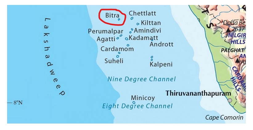
About Bitra Island:
- Location: Situated in the Arabian Sea; part of the Amindivi subgroup of the Lakshadweep archipelago
- Distance from Mainland: ~483 km west of Kochi
- Land Area: 0.10–0.18 square kilometres
- Population: ~271–350 (as of 2025)
- Language and Livelihood
- Languages Spoken: Malayalam, Mahl, and English
- Economic Activities: Fishing, coconut farming, and emerging ecotourism (birdwatching, snorkeling, diving)
- Climate:
- Type: Tropical monsoon (similar to Kerala)
- Temperature Range: 25–35°C
- Annual Rainfall: ~1600 mm
- Monsoon Season: Mid-May to mid-September; sea access is limited
- Historical and Cultural Significance:
- History: Populated around 1945
- Pilgrimage Site: Hosts a shrine to Arab saint Malik Mulla
Strategic Importance:
- Location: Close to key international shipping lanes in the Arabian Sea
- Surveillance Advantage: Ideal point for maritime monitoring
- Military Utility: Suitable for naval installations and coastal defence
- Maritime Awareness: Enhances India’s preparedness in the western seaboard
| [UPSC 2014] Which one of the following pairs of islands is separated from each other by the ‘Ten Degree Channel’?
Options: (a) Andaman and Nicobar* (b) Nicobar and Sumatra (c) Maldives and Lakshadweep (d) Sumatra and Java |
Get an IAS/IPS ranker as your 1: 1 personal mentor for UPSC 2024
Attend Now
Why in the News?
Five strong offshore earthquakes hit Russia’s Kamchatka Peninsula, the strongest measuring 7.4 in magnitude.
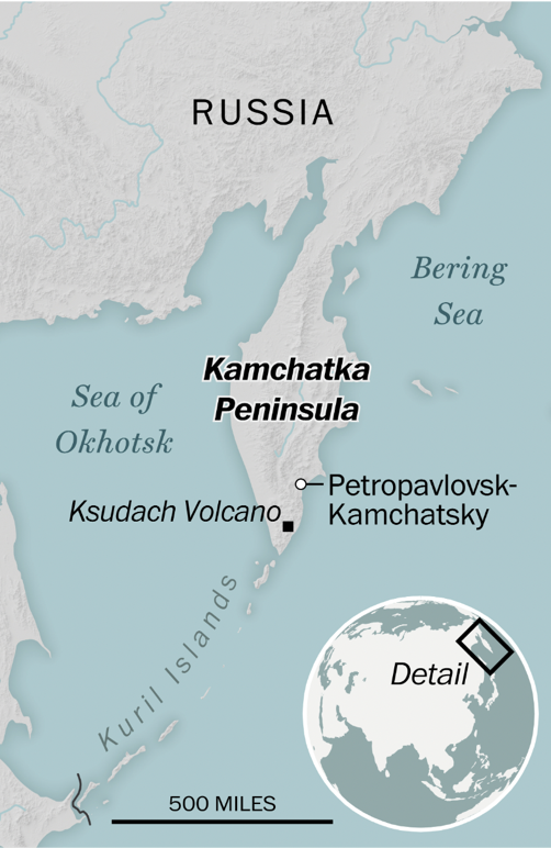
About Kamchatka Peninsula:
- Location: Situated in Far Eastern Russia, bordered by the Sea of Okhotsk (west) and the Pacific Ocean and Bering Sea (east).
- Size and Shape: Stretches about 1,200 km north to south and 480 km at its widest point.
- Area: Covers approximately 370,000 square kilometers—comparable in size to New Zealand.
- Ethnic Composition: Majority are ethnic Russians; around 13,000 belong to the indigenous Koryak community.
- Climate: Harsh with long, snowy winters and wet, cool summers.
- Topography: Highest peak is Klyuchevskaya Sopka, an active volcano in the Eastern Mountain Range.
- Global Recognition: Hosts the “Volcanoes of Kamchatka,” a UNESCO World Heritage Site.
Tectonic Significance:
- Geological Setting: Lies on the Pacific Ring of Fire, making it a global hotspot for seismic and volcanic activity.
- Volcanic Density: Contains over 150 volcanoes, 29 of which are currently active.
- Kuril–Kamchatka Trench: Located just offshore, reaches depths of about 10,500 meters and drives regional seismicity.
- Tectonic Cause: Caused by subduction of the Pacific Plate beneath the Eurasian Plate.
| [UPSC 2004] Consider the following geological phenomena:
1. Development of a fault 2. Movement along a fault
3. Impact produced by a volcanic eruption 4. Folding of rocks
Which of the above cause earthquakes?
Options: (a) 1, 2 and 3 (b) 2 and 4 (c) 1, 3 and 4 (d) 1, 2, 3 and 4* |
Get an IAS/IPS ranker as your 1: 1 personal mentor for UPSC 2024
Attend Now