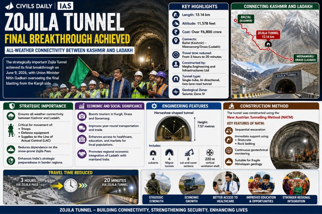
💥UPSC 2026, 2027, 2028 UAP Mentorship (March Batch) + Access XFactor Notes & Microthemes PDF

Type: World Mapping

  • Foreign Policy Watch: India – EU

    India–Finland Relations Elevated to Strategic Partnership

    Why in the News

    India and Finland have elevated their bilateral relations to a “Strategic Partnership in Digitalization and Sustainability” after talks between Narendra Modi and Finnish President Alexander Stubb in New Delhi.

    Key Outcomes of the Visit

    Strategic Partnership Focus

    • Cooperation will expand in high-technology sectors such as:
      • Artificial Intelligence
      • 6G telecommunications
      • Clean energy
      • Quantum computing
      • Digital infrastructure

    Agreements Signed

    • Three agreements were signed in the fields of:
      • Mobility cooperation
      • Environment and sustainability
      • Statistics and data sharing

    New Institutional Mechanisms

    The two countries will establish:

    • Joint Working Group on Digitalization
    • Joint Task Force on 6G technology
    • Consular Dialogue mechanism
    • Greater connectivity between startup ecosystems

    Economic Cooperation

    • India and Finland aim to double bilateral trade by 2030.
    • The countries will co-host the World Circular Economy Forum in India.
    • Cooperation expected in sectors such as: Defence, Space, Semiconductors and Critical minerals

    Existing India–Finland Cooperation

    Examples highlighted during the meeting include:

    • Finnish company Nokia helping build telecom networks in India.
    • Finnish architectural collaboration in constructing the Chenab Railway Bridge.
    • Finland’s partnership in establishing the world’s largest bamboo-to-bioethanol refinery at Numaligarh in Assam.
    Consider the following countries: 1. Finland  2. Germany  3. Norway  4. Russia How many of the above countries have a border with the North Sea? (a) Only one (b) Only two (c) Only three (d) All four
  • Foreign Policy Watch: India-Middle East

    Renewed Conflict Between Syrian Government and Kurds

    Why in the News?

    Renewed fighting has erupted in Syria between government forces led by interim leader Ahmed al-Sharaa and the Kurdish-led Syrian Democratic Forces (SDF), threatening to roll back Kurdish autonomy that has existed since the 2011 civil war.

    Background Context

    • The regime of Bashar al-Assad collapsed in December 2024
    • Ahmed al-Sharaa promised an inclusive administration but pushed for a centralised Syrian state
    • Ethnic and religious minorities, including Kurds, resisted centralisation
    • Sectarian violence resurfaced against Alawites and Druze, followed by clashes with Kurds

    Who Are the Syrian Kurds?

    • Kurds form about 10 percent of Syria’s population
    • Concentrated in north and northeast Syria
    • Long standing demand for autonomy, not secession
    • In 2012, Assad withdrew troops from the northeast
    • Kurds filled the vacuum and declared autonomous regions called cantons
    • These areas together formed the Democratic Autonomous Administration of North and East Syria (DAANES), also called Rojava
    [2016] Consider the following pairs: Community sometimes mentioned in the news : In the affairs of 

    1. Kurd : Bangladesh 

    2. Madhesi : Nepal 

    3. Rohingya : Myanmar 

    Which of the pairs given above is/are correctly matched? 

    (a) 1 and 2 (b) 2 only (c) 2 and 3 (d) 3 only

  • Foreign Policy Watch: India-Russia

    Mount Elbrus

    Why in the News?

    A controlled avalanche was artificially triggered on Mount Elbrus in Russia to safely release accumulated snow following heavy snowfall, reducing the risk of natural avalanches.

    About

    • Highest mountain in Europe
    • An ancient, extinct volcano with two distinct peaks
    • Part of the Caucasus mountain system
    • Major hub for mountaineering and alpine tourism

    Location

    • Situated in southwestern Russia
    • Lies in the Caucasus Mountains, just north of the Georgia border
    • Located between the Black Sea and Caspian Sea mountain corridor

    Key geological features

    • Twin coned stratovolcano formed over 2.5 million years ago
    • Highest peak at 5,642 metres
    • Second peak at 5,595 metres
    • Covered by 22 glaciers
    • Feeds major rivers such as Kuban and Terek
    • Though dormant for nearly 2,000 years, still shows sulphurous gas emissions and mineral springs

    Significance

    • Officially recognised as Europe’s highest peak
    • Included among the Seven Summits for global climbers
    • Important site for glaciological research and climate change studies
    • Observed by scientific missions including the International Space Station
    • Economically vital for tourism and adventure sports in the Caucasus region

    UPSC Prelims Pointers

    • Mount Elbrus is higher than Mont Blanc
    • It is an extinct stratovolcano, not a fold mountain
    • Located in the Caucasus, between the Black Sea and Caspian Sea
    • Hosts extensive glaciation despite being dormant
    • Controlled avalanches are used for disaster risk reduction in high mountain regions
    [2014] Turkey is located between: 

    (a) Black Sea and Caspian Sea 

    (b) Black Sea and Mediterranean Sea 

    (c) Gulf of Suez and Mediterranean Sea 

    (d) Gulf of Aqaba and Dead Sea

  • Foreign Policy Watch: India-Africa

    Somaliland  

    Why in the News?

    Recently, Israel formally recognised the self declared Republic of Somaliland as an independent and sovereign state.

    About Somaliland

    • Located in the Horn of Africa
      • Borders Djibouti, Ethiopia, Somalia, and the Puntland region
      • Has a strategic coastline along the Gulf of Aden
      • Capital city Hargeisa

    Economy and Infrastructure

    • Economy primarily livestock based
      • Major exports of livestock to Gulf countries
      Berbera Port is being developed as a regional trade and logistics hub
      • Port plays a key role in providing access to sea trade for landlocked Ethiopia

    Prelims Pointers

    • Somaliland is not a UN recognised state despite functioning independently
      • Located along a strategic maritime route near the Bab el Mandeb region
      • Unique political system combining customary institutions and democracy
      • Berbera Port enhances regional connectivity in the Horn of Africa
    Which of the following countries has been suffering from decades of civil strife and food shortages and was in news in the recent past for its very severe famine? [2023]

    (a) Angola 

    (b) Costa Rica 

    (c) Ecuador 

    (d) Somalia

  • Foreign Policy Watch: India-Middle East

    Hormuz Island

    Why in the News?

    • A rare natural phenomenon turned the coastlines of Hormuz Island into a blood red landscape, drawing global attention

    About Hormuz Island

    Location: Iran, on the Strait of Hormuz
    • Lies between the Persian Gulf and the Gulf of Oman
    • Situated about 8 km off the Iranian coast
    Area: 41.9 sq km
    • A hilly island with distinctive geomorphology

    Geological Features

    • Composed mainly of sedimentary rocks and volcanic ash
    • Dominant red colour due to high iron oxide content
    • Presence of hematite mineral gives the soil its deep red hue
    Ocean waves turn pink when they wash over iron rich sands

    Soil and Climate

    • Experiences low precipitation
    Soil and water are saline in nature
    • Landscape is largely barren

    Unique Identity

    • Known as Rainbow Island due to multi coloured soil
    • Sand and soil colours include red, gold, silver, and white

    Human Settlement and Livelihood

    Hormuz village is the only permanent settlement
    Fishing is the primary source of livelihood
    • Inhabited mainly by the Bandari ethnic group

    What is the importance of developing Chabahar Port by India? (2017)

    (a) India’s trade with African countries will enormously increase. 

    (b) India’s relations with oil-producing Arab countries will be strengthened. 

    (c) India will not depend on Pakistan for access to Afghanistan and Central Asia. 

    (d) Pakistan will facilitate and protect the installation of a gas pipeline between Iraq and India.

  • Global Geological And Climatic Events

    Sakurajima Volcano erupts in Japan’s Kyushu

    Why in the News?

    Japan’s Sakurajima volcano has erupted several times sending ash plumes up to 4.4 km into the atmosphere.

    Sakurajima Volcano erupts in Japan's Kyushu

    About Sakurajima Volcano:

    • Location: Kagoshima Prefecture, Kyushu, sitting on the southern rim of the Aira caldera inside Kagoshima Bay.
    • Geological Origin: Linked to formation of the Aira caldera (22,000–29,000 years ago); Sakurajima developed as a post-caldera cone about 13,000 years ago.
    • Volcano Type: A classic stratovolcano built from alternating lava and ash layers; active vents include Minamidake crater and the Showa flank crater.
    • Physical Features: Height 1,117 m, circumference ≈50 km; originally an island until 1914 lava flows connected it to the Osumi Peninsula.
    • Eruption Style: Dominantly Strombolian eruptions (ash, bombs, lapilli) but historically capable of large Plinian eruptions.
    • Historical Activity: Continuous eruptive record since 963 AD; major episodes in 1471–76, 1779–82, and the 1914 catastrophic eruption.
    • Risk Status: Considered one of Japan’s most dangerous volcanoes due to high activity, caldera-linked magma supply and extreme proximity to inhabited zones.

    What makes it unique?

    • Near-Continuous Activity: Erupts hundreds of times annually, ranking among the world’s most persistently active volcanoes.
    • Caldera System: Built on the Aira caldera, giving it a deep, complex, highly active magma plumbing network.
    • Landform Transformation: The 1914 eruption converted Sakurajima from an island into a peninsula, an unusual event in recorded volcanology.
    [UPSC 2005] Where is the volcanic mountain, Mount St- Helens located?

    Options: (a) Chile (b) Japan (c) Philippines (d) United States of America*


  • Contention over South China Sea

    Senkaku-Diaoyu Islands Issue

    Why in the News?

    A China Coast Guard formation patrolled the Senkaku waters as Beijing escalated tensions with Japan over recent remarks on Taiwan.

    Senkaku-Diaoyu Islands Issue

    About the Senkaku–Diaoyu Islands Issue:

    • Location & Status: A small uninhabited island group in the East China Sea, claimed by Japan, China, and Taiwan.
    • Names: Japan calls them Senkaku, China Diaoyu, and Taiwan Diaoyutai.
    • Administration: Japan has administered the islands since 1972 after the Okinawa Reversion Agreement with the United States.
    • Geography: Consists of five islands and three rocks, covering ~7 sq km; the largest is Uotsuri.
    • Strategic Location: Situated near major shipping lanes linking East Asia to global trade routes.
    • Natural Resources: Surrounding waters believed to hold oil and natural gas deposits, highlighted in a 1969 UN report.
    • Fisheries: Rich fishing grounds add significant economic importance.
    • Geopolitical Value: Located at the junction of interests of Japan, China, Taiwan, and the United States, making it a strategic flashpoint.

    What is the Dispute?

    • Japanese Claim: Japan incorporated the islands in January 1895, asserting they were terra nullius based on surveys from 1885 that found no Chinese administration.
    • Chinese & Taiwanese Claim: Cite dynastic-era maps, navigation records, and Qing documents to argue sovereignty predates Japanese control.
    • Post–World War II Status: The US took control under the 1951 San Francisco Treaty, administering the islands as part of the Nansei Shoto region.
    • 1971 Shift: Transfer of Senkaku and Okinawa back to Japan under the Okinawa Reversion Agreement sparked protests from China and Taiwan.
    • Resource Trigger: China’s active claim strengthened after the 1969 UN report identified potential hydrocarbon reserves.
    • 2012 Escalation: Japan’s purchase of three privately owned islands led to widespread protests, attacks on Japanese businesses, and a surge in nationalist sentiment in China.
    • Current Tensions: Chinese Coast Guard vessels frequently enter surrounding waters to assert Beijing’s claim.
    • Broader Dynamics: Linked to nationalism, unresolved historical grievances, and strategic competition between China, Japan, and the United States across the Indo-Pacific.
    [UPSC 2022] Which one of the following statements best reflects the issue with Senkaku Islands, sometimes mentioned in the news?

    Options: (a) It is generally believed that they are artificial islands made by a country around South China Sea.

    (b) China and Japan engage in maritime disputes over these islands in East China Sea.*

    (c) A permanent American military base has been set up there to help Taiwan to increase its defence capabilities.

    (d) Though International Court of Justice declared them as no man’s land, some South-East Asian countries claim them.


  • Foreign Policy Watch: India-Africa

    Civil War in Sudan

    Why in the News?

    The United Nations Secretary-General has warned that the civil war in Sudan is “spiralling out of control” after the Rapid Support Forces (RSF) seized the strategic Darfur city of El-Fasher.

    Civil War in Sudan

    About the Civil War in Sudan:

    • Outbreak: Began in April 2023 between the Sudanese Armed Forces (SAF) led by Gen. Abdel Fattah al-Burhan and the Rapid Support Forces (RSF) led by Gen. Mohamed Hamdan Dagalo (Hemedti).
    • Causes: Rooted in Sudan’s failed democratic transition after the 2019 overthrow of Omar al-Bashir and the October 2021 military coup.
    • Immediate Trigger: Power struggle over RSF integration into the national army under the proposed political framework agreement.
    • Conflict Spread: Fighting engulfed Khartoum, Omdurman, and Darfur, causing massive civilian casualties and infrastructure collapse.
    • Humanitarian Toll: Over 8.5 million displaced, famine conditions emerging, and public health systems near total breakdown.
    • Atrocities: Both sides accused of war crimes, ethnic killings, and looting, particularly in Darfur.
    • Territorial Shift: RSF’s capture of El-Fasher (2025) consolidated its control over western Sudan.
    • Foreign Actors: Egypt supports SAF; UAE and Russia’s Wagner Group back RSF, fuelling proxy dynamics.

    What Lies Ahead?

    • Risk of Partition: Sudan may split RSF holding the west, SAF dominating the northeast, leading to de-facto fragmentation.
    • Regional Destabilisation: Prolonged conflict could spill into the Horn of Africa and Red Sea corridor, worsening insecurity.
    • Political Outlook: Civilian transition appears remote; both factions remain focused on military dominance.
    • Economic Collapse: Inflation above 250%, agricultural failure deepening food insecurity.
    • Regional Impact: Refugee influx threatens Chad, South Sudan, and Ethiopia with cross-border instability.
    [UPSC 2024] Consider the following pairs: Country Reason for being in the news
    1. Argentina Worst economic crisis
    2. Sudan War between the country’s regular army and paramilitary forces
    3. Turkey Rescinded its membership of NATO
    How many of the pairs given above are correctly matched?
    Options: (a) Only one pair (b) Only two pairs* (c) All three pairs (d) None of the pairs


  • Foreign Policy Watch- India-Central Asia

    India’s exit from the Ayni Airbase in Tajikistan

    Why in the News?

    ​India’s complete pullout from the Ayni Airbase in Tajikistan (in 2022), its sole foreign military post, drew sharp opposition’s criticism.

    India’s exit from the Ayni Airbase in Tajikistan

    About Ayni Airbase:

    • Location: Situated 10 km west of Dushanbe, Tajikistan, near the Afghanistan border via the Wakhan Corridor, and about 20 km from Pakistan-occupied Kashmir (PoK).
    • Also known as: Known as Gissar Air Base or Gissar Military Aerodrome; originally a Soviet-era base later modernised by India.
    • Development by India: Upgraded by India in the early 2000s under a bilateral agreement with Tajikistan; India invested ~USD 100 million to extend the runway (3,200 m), build hangars, depots, and control systems.
    • Operational Role: Hosted IAF helicopters and Su-30MKI fighters, with ~200 Indian personnel managing repair and training operations; also supported humanitarian and evacuation missions, notably during the 2021 Taliban takeover.
    • Predecessor: Replaced Farkhor Airbase (1998–2008), India’s earlier base used for supporting the Northern Alliance in Afghanistan.

    Strategic Significance of the Airbase:

    • Forward Presence: Gave India surveillance and strike reach over Afghanistan and Pakistan’s western front.
    • Regional Leverage: Enhanced India’s defence footprint in Central Asia, countering China’s BRI and Russian influence.
    • Operational Hub: Supported the then anti-Taliban Northern Alliance and India’s broader Connect Central Asia Policy (2012).
    • Evacuation & Logistics Node: Enabled rapid crisis evacuation and regional logistical operations.
    • Geopolitical Symbolism: Marked India’s aspiration for a continental strategic presence; its closure reflects shrinking influence west of the Himalayas amid Russia–China consolidation.

    Reasons for India’s Exit:

    • Lease Expiry: The bilateral lease expired in 2022 and was not renewed by Tajikistan.
    • External Pressures: Russia and China discouraged Tajikistan from extending India’s presence.
    • Strategic Shift: Diminished relevance post-Taliban’s return (2021) and collapse of India’s Afghan network.
    • Operational Constraints: High costs, limited autonomy, and dependence on Russian logistics reduced viability.
    • Reorientation: Strategic focus moved toward the Indo-Pacific and maritime partnerships.
    [UPSC 2022] Consider the following countries :

    1. Azerbaijan 2. Kyrgyzstan 3. Tajikistan 4. Turkmenistan 5. Uzbekistan

    Which of the above have borders with Afghanistan?

    Options: (a) 1, 2 and 5 only (b) 1, 2, 3 and 4 only (c) 3, 4 and 5 only* (d) 1, 2, 3, 4 and 5


  • Global Geological And Climatic Events

    Taftan Volcano, Iran 

    Why in the News?

    New satellite data in Geophysical Research Letters (October 2025) shows Iran’s Taftan volcano, dormant for 710,000 years, is reactivating.

    Taftan Volcano, Iran 

    About Taftan Volcano:

    • Location: Situated in southeastern Iran, about 56 km from the Pakistan border, within the Makran continental volcanic arc.
    • Elevation: Rises to 3,940 metres (12,927 feet), Iran’s only active volcano in the Makran arc.
    • Tectonic Origin: Formed by subduction of the Arabian oceanic plate beneath the Eurasian continental plate.
    • Volcanic Type & Composition: A stratovolcano composed mainly of andesitic and dacitic lava, with pyroclastic flows and volcanic breccias.
    • Structure: Features two summits, Narkuh and Matherkuh, and extensive ignimbrite and lava fans stretching over 30 km.
    • Hydrothermal Activity: Hosts sulfur-emitting fumaroles, visible from up to 100 km, sustained by an active hydrothermal system.
    • Eruptive History: Major activity phases around 8 Ma, 6 Ma, and 0.7 Ma; last lava flow dated to about 6,950 years ago.
    • Recent Observations: 2023–24 satellite data detected 9 cm ground uplift, indicating subsurface pressure buildup and reclassification from extinct to dormant.

    Scientific Interpretation and Outlook:

    • Magma Dynamics: Uplift linked to gas accumulation or shallow magma intrusion at 490–630 m depth, possibly fed by deeper chambers (~3.5 km).
    • Current Status: No imminent eruption expected; likely pressure release via degassing or minor eruptions.
    • Monitoring Gap: Lack of ground-based GPS or seismic sensors; reliance on satellite InSAR data for deformation tracking.
    • Scientific Recommendations: Call for establishing a volcano observatory in southeastern Iran for real-time monitoring and gas analysis.
    • Regional Significance: Highlights Makran arc tectonic activity and underscores the need for international geophysical collaboration.
    • Research Importance: Taftan’s reawakening demonstrates the role of remote sensing in detecting hidden volcanic unrest and stresses continuous monitoring to assess eruption potential and regional hazard mitigation.
    [UPSC 2024] Consider the following:
    1. Pyroclastic debris 2. Ash and dust 3. Nitrogen compounds 4. Sulphur compoundsHow many of the above are products of volcanic eruptions?Options: (a) Only one (b) Only two (c) Only three (d) only four*


  • Volga River

    Why in the News?

    This newscard is an excerpt from the original article published in the Indian Express.

    Volga River

    About the Volga River:

    • Overview: The longest river in Europe (about 3,500 km), originating in the Valdai Hills northwest of Moscow and flowing southeast to the Caspian Sea at Astrakhan.
    • Drainage Basin: Covers around 1.35 million sq. km, among Europe’s largest river systems, with major tributaries, Kama, Oka, Vetluga, and Sura.
    • Historical Role: Served as a critical front during the Battle of Stalingrad (World War II) and remains central to Russian historical and strategic narratives.
    • Cultural Significance: Revered as “Mother Volga”, symbolising Russian unity, resilience, and identity, deeply embedded in folklore and national consciousness.
    • Economic Importance: It contributes one-fourth of Russia’s agricultural output, supports industrial fishing, and sustains key industries, oil refining, shipbuilding, hydroelectric power.
    • Navigation & Connectivity: Linked to the Baltic, Black, and Caspian Seas through an extensive network of canals and reservoirs, forming the backbone of Russia’s inland transport system.
    • Urban & Industrial Corridor: Major cities like Kazan, Samara, Nizhny Novgorod, and Volgograd lie along its course, forming Russia’s industrial-agricultural heartland.
    • Ecological Richness: Supports about 260 bird species and 70 fish species, making it a key biodiversity hotspot within Eurasia.
    [UPSC 2020] Consider the following pairs: River Flows into

    1. Mekong: Andaman Sea

    2. Thames: Irish Sea

    3. Volga: Caspian Sea

    4. Zambezi: Indian Ocean

    Which of the pairs given above is/are correctly matched?

    Options: (a) 1 and 2 only (b) 3 only (c) 3 and 4 only * (d) 1, 2 and 4 only


  • Contention over South China Sea

    Scarborough Shoal in South China Sea

    Why in the News?

    China’s State Council has approved the creation of a national nature reserve at Scarborough Shoal (Huangyan Dao in Chinese, Bajo de Masinloc/Panatag Shoal in the Philippines).

    About Scarborough Shoal:

    • Geography: A triangle-shaped chain of reefs and rocks in the South China Sea, about 200 km from Luzon (Philippines) and 800+ km from Hainan (China).
    • Status: Uninhabited but strategic, located near shipping lanes carrying $3 trillion in trade annually.
    • Significance: The lagoon shelters boats, and surrounding waters hold rich fish stocks vital for Zambales and Pangasinan communities.

    Disputes about it:

    • Sovereignty Claims: Both China and the Philippines claim ownership.
    • 2016 Arbitration Ruling: Permanent Court of Arbitration (The Hague) held China’s nine-dash line claim invalid, declaring Scarborough a traditional fishing ground under UNCLOS; China rejected the verdict.
    • Philippines’ Grounds: Lies within Manila’s Exclusive Economic Zone (EEZ), making China’s reserve “illegitimate and unlawful.”
    • International Response: The US, Japan, Australia, and Canada conduct naval patrols/drills supporting the Philippines and freedom of navigation.
    [UPSC 2022] Which one of the following statements best reflects the issue with Senkaku Islands, sometimes mentioned in the news ?

    Options: (a) It is generally believed that they are artificial islands made by a country around South China Sea.

    (b) China and Japan engage in maritime disputes over these islands in East China Sea.*

    (c) A permanent American military base has been set up there to help Taiwan to increase its defence capabilities.

    (d) Though International Court of Justice declared them as no man’s land, some South-East Asian countries claim them.


  • Climate Change Impact on India and World – International Reports, Key Observations, etc.

    In news: Pugad Island

    Why in the News?

    The Philippine island of Pugad in Manila Bay is facing an existential threat as rising sea levels and rapid land subsidence combine to submerge homes and livelihoods.

    About Pugad Island:

    • Overview: Small 7-hectare island in Manila Bay, situated at the mouth of the Angat–Pampanga River Delta, under Hagonoy municipality, Bulacan province, Philippines.
    • Population: Home to about 1,636–2,056 residents, living in a single clustered village of roughly 384 houses.
    • Livelihoods: Community depends on fishing and aquaculture, with families cultivating clams, mussels, and whiting fish in converted fishponds.
    • Living Conditions: Houses built mainly from bamboo and old metal sheets, with poor sanitation, minimal healthcare facilities, and only elementary-level schooling.
    • Flooding Challenge: Regularly hit by high-tide and monsoon floods, made worse by land subsidence (11 cm/year) and sea-level rise (three times global average).
    • Environmental Hazards: Loss of mangroves, urban encroachment, and exposure to typhoons increase risks of disaster and displacement.
    [UPSC 2018] Which of the following has/have shrunk immensely/dried up in the recent past due to human activities?

    1.Aral Sea 2.Black Sea 3.Lake Baikal

    Select the correct answer using the code given below:

    (a) 1 only (b) 2 and 3 only (c) 2 only (d) 1 and 3*


  • Disasters and Disaster Management – Sendai Framework, Floods, Cyclones, etc.

    In news: Sudan’s Darfur Region

    Why in the News?

    A landslide in Sudan’s western Darfur region reportedly wiped out a village, killing an estimated 1,000 people.

    In news: Sudan’s Darfur Region

    About Darfur Region:

    • Location & Size: Western Sudan; borders Chad, Libya, CAR; spans about 493,000 sq. km (nearly France-sized).
    • Geography: Predominantly arid/semi-arid; desert north, fertile south. Highly vulnerable to drought, desertification, and climate change.
    • Administrative Units: Divided into five states — North, South, West, Central, East Darfur.
    • Demographics: Mixed ethnic groups — Arab pastoralists and non-Arab farming communities.
    • Capital: El Fasher, main hub for administration, economy, and humanitarian operations.

    Ongoing Conflict & Crisis:

    • Origins of Uprising: Armed rebellion began in 2003 (SLM, JEM) against political and economic marginalization.
    • Janjaweed & RSF: Janjaweed militias, accused of genocide and ethnic cleansing, later evolved into Rapid Support Forces (RSF), now central to instability.
    • Humanitarian Crisis: Since 2003, region has seen mass killings, displacement, refugee flows, ranked among the worst global humanitarian crises.
    • Current Instability: Renewed 2023 violence between RSF and rival groups worsened agriculture, aid, and governance.
    • Regional Impact: Conflict spills into Chad and CAR, destabilizing the Sahel region.
    • Natural Disasters: Alongside conflict, disasters like the 2025 Darfur landslide (~1,000 deaths) add to human suffering.
    [UPSC 2024] Consider the following statements:

    Statement-I: There is instability and worsening security situation in the Sahel region.

    Statement-II: There have been military takeovers/coups d’état in several countries of the Sahel region in the recent past.

    Which one of the following is correct in respect of the above statement?

    a) Both Statement-I and Statement-II are correct and Statement-II explains Statement-I

    b) Bothe Statement-I and Statement-II are correct, but Statement-II does not explain Statement-I

    c) Statement-I is correct, but Statement-II is incorrect

    d) Statement-I is incorrect, but Statement-II is correct


  • Global Geological And Climatic Events

    Mount Etna Eruption

    Why in the News?

    Mount Etna has erupted again after its recent eruption in June.

    About Mount Etna:

    • Location: Situated on the east coast of Sicily, Italy, near the city of Catania.
    • Type: Mount Etna is a stratovolcano (also called a composite volcano), which is formed from layers of hardened lava, volcanic ash, and rocks.
    • Height: It stands at approximately 3,300 meters, making it the tallest volcano in Europe south of the Alps.
    • Recognition: Declared a UNESCO World Heritage Site in 2013, with documented volcanic activity for at least 2,700 years.
    • Eruption Record: Etna is almost constantly active. Notable eruptions have occurred in 1400 B.C., 1669, 2001, 2018, 2021, 2024, and 2025.
    • Volcanic Activity Style: Known for Strombolian and effusive eruptions, with occasional Plinian eruptions (rare and more explosive).

    Reasons Behind the Eruption:

    • Nature of Eruption: The eruption is classified as either Strombolian or possibly Plinian, depending on interpretation:
      • Strombolian Eruption: Characterized by moderate explosive bursts, caused by gas bubbles in magma suddenly bursting at the surface.
      • Plinian Eruption: Some volcanologists suggest this classification due to the large ash column that may have reached the stratosphere.
    • Eruption Trigger: The eruption likely began due to pressure buildup from gas within the magma chamber, leading to collapse of the southeast crater and lava flows.
    [UPSC 2014] Consider the following geological phenomena:

    1. Development of a fault

    2. Movement along a fault

    3. Impact produced by a volcanic eruption

    4. Folding of rocks Which of the above cause earthquakes?

    Options: (a) 1, 2 and 3 (b) 2 and 4 (c) 1, 3 and 4 (d) 1, 2, 3 and 4*


  • Russian Invasion of Ukraine: Global Implications

    In news: Donbas Region

    Why in the News?

    The mineral-rich Donbas region remains central to future of Russia-Ukraine peace talks.

    About Donbas Region:

    • Constituent Areas: Includes Donetsk and Luhansk oblasts in eastern Ukraine.
    • Geographical Position: Bordered by the Sea of Azov in the south, which connects to the Black Sea via the Strait of Kerch.
    • Industrial Hub: Known as Ukraine’s industrial heartland due to large mineral and energy resources.
    • Coal Reserves: Ukraine possesses ~32 gigatonnes of hard coal, most concentrated in Donbas (IEA estimate).
    • Shale Gas Potential: Yuzivska shale gas field (Donetsk–Kharkiv) holds 1.2–2 trillion cubic metres of gas in place, one of Europe’s largest untapped reserves.
    • Salt Production: Home to Artemsil, once among Europe’s largest salt mines, producing ~2 million tonnes annually until closed in 2022 due to conflict.

    Strategic Significance of the Region:

    • For Russia:
      • Resources: Rich in coal, shale gas, salt, and coal bed methane, enhancing its resource security.
      • Geography: Provides land link to Crimea and direct access to the Sea of Azov.
      • Demographics: Large Russian-speaking population offers political and cultural leverage.
    • For Ukraine:
      • Economy: Core to industrial base, especially steel production.
      • Energy Security: Control of Yuzivska shale gas could reduce reliance on imports.
      • Sovereignty: Represents a vital part of national unity and territorial integrity.
    • Geopolitical Dimension: Sea of Azov crucial for connecting Donbas resources to Black Sea trade routes.
    • Conflict Relevance: Since Crimea’s annexation (2014) and escalation in 2022, control of Azov and Kerch Strait vital for Russia’s naval dominance.
    [UPSC 2023] Consider the following pairs: Area of conflict mentioned in news : Country where it is located

    1. North Kivu and Ituri : War between Armenia and Azerbaijan

    2. Nagorno-Karabakh : Insurgency in Mozambique

    3. Kherson and Zaporizhzhia : Dispute between Israel and Lebanon

    How many of the above pairs are correctly matched?

    Options: (a) Only one (b) Only two (c) All three (d) None*


  • Foreign Policy Watch: India-Africa

    African Union (AU) and the Mercator Map Debate

    Why in the News?

    The African Union (AU) has endorsed the Correct the Map campaign to replace the 16th-century Mercator projection with more accurate maps.

    African Union (AU) and the Mercator Map Debate

    About the African Union (AU):

    • Establishment: Formed in 2002, replacing the Organisation of African Unity (1963).
    • Membership: 55 African countries.
    • Headquarters: Addis Ababa, Ethiopia.
    • Vision: “An Integrated, Prosperous, and Peaceful Africa, driven by its own citizens.”
    • Agenda 2063: Blueprint for socio-economic growth and continental unity.
    • Main Organs: Assembly, Executive Council, AU Commission, Peace and Security Council.

    What is a Mercator Map?

    • Creation: Designed in 1569 by Gerardus Mercator.
    • Projection: Cylindrical map with straight longitude and latitude lines intersecting at 90°.
    • Purpose: Enabled sailors to plot straight-line courses for compass navigation.
    • Adoption: Became the standard map in schools, atlases, and wall charts by the 19th century.

    Issues with the Mercator Map:

    • Distortion: Enlarges high-latitude regions (Europe, Russia, North America) while shrinking Africa and South America.
    • Example: Greenland appears equal to Africa, though Africa is ~14 times larger.
    • Colonial Bias: Reinforced Western dominance narratives and downplayed Africa’s size and importance.
    • Impact: Supported marginalisation and exploitation during colonialism.
    • Alternatives: Gall-Peters (1970s) and Equal Earth (2018) projections show continents in correct proportion.
    • AU Stand: Advocates replacing Mercator maps to restore Africa’s rightful global image.
    [UPSC 2024] The longest border between any two countries in the world is between:

    Options: (a) Canada and the USA * (b) Chile and Argentina (c) China and India (d) Kazakhstan and Russian Federation


  • Russian Invasion of Ukraine: Global Implications

    Russia’s Sale of Alaska to US

    Why in the News?

    United States President Donald Trump and his Russian counterpart Vladimir Putin are set to meet in Anchorage, Alaska to discuss how to end the war in Ukraine.

    Russia's Sale of Alaska to US

    About Alaska:

    • Acquisition: Largest U.S. state; Purchased from Russia in 1867 for $7.2 million.
    • Mountains: Includes Alaska Range with Mount Denali (20,310 ft), the highest peak in North America.
    • Geography: Brooks Range separates central Alaska from the Arctic far north.
    • Tundra: Northern regions feature vast tundra, permafrost, and Arctic coastal plains.
    • Glaciers: Hosts 100,000+ glaciers, including Bering Glacier, the largest in North America.
    • Forests: About 5% glacier ice, with extensive boreal and temperate rainforests in the south.
    • Volcanoes: More than 70 active volcanoes in Aleutians and Alaska Peninsula.
    • Seismic Activity: Located on the circum-Pacific seismic belt, prone to powerful quakes (e.g., 1964 Alaska earthquake).
    • Water Resources: Contains 3 million+ lakes and 3,000+ rivers, among the most water-rich regions globally.
    • Peninsulas: Includes Alaska Peninsula, Kenai Peninsula, and Seward Peninsula (linked to ancient Bering land bridge).

    Why did Russia sell Alaska to the US?

    • After the Crimean War (1853–56), Russia was financially strained and needed funds.
    • Alaska was seen as a remote, unprofitable liability with declining fur trade.
    • Russia feared Britain might seize Alaska easily from nearby Canada in a future war.
    • Selling it to the United States ensured goodwill and balanced British power.
    • The $7.2 million sale (1867) turned a weakly defended outpost into cash for reforms.

    Geopolitical Significance of Alaska:

    • Natural Resources: Rich in oil, gas (e.g., Prudhoe Bay discovery, 1968), fisheries, and minerals vital for U.S. energy security.
    • Shipping Routes: Offers access to Arctic Sea routes, increasingly navigable due to climate change.
    • Strategic Gateway: Provides access to the Arctic and Pacific, enhancing U.S. naval and air capabilities.
    • Defense Value: Proximity to Russia made it critical in the Cold War and remains vital in Arctic competition.
    • Military Presence: Hosts major U.S. bases and radar systems for missile defense and surveillance.
    • Arctic Council Role: Strengthens U.S. claims in polar governance and Arctic Council negotiations.
    • Scientific Hub: Serves as a center for climate, seismic, and polar ecosystem research.
    [UPSC 2025] Consider the following statements:

    I. Anadyr in Siberia and Nome in Alaska are a few kilometers from each other, but when people are waking up and getting set for breakfast in these cities, it would be different days.

    II. When it is Monday in Anadyr, it is Tuesday in Nome.

    Which of the statements given above is/are correct?

    (a) I only * (b) II only (c) Both I and II (d) Neither I nor II


  • Foreign Policy Watch: United Nations

    Third United Nations Conference on Landlocked Developing Countries (LLDC3)

    Why in the News?

    The 3rd UN Conference on Landlocked Developing Countries (LLDC3) in Awaza, Turkmenistan, adopted the Awaza Declaration to boost investment, address challenges, and promote sustainable growth in 32 landlocked nations.

    Third United Nations Conference on Landlocked Developing Countries (LLDC3)

    About Landlocked Developing Countries (LLDCs):

    • Overview: 32 UN-recognized countries with no direct access to the sea, collectively home to over 600 million people.
    • List of LLDCs:
      1. Africa: Botswana, Burkina Faso, Burundi, Central African Republic, Chad, Eswatini, Ethiopia, Lesotho, Malawi, Mali, Niger, Rwanda, South Sudan, Uganda, Zambia, Zimbabwe.
      2. Asia: Afghanistan, Bhutan, Kazakhstan, Kyrgyzstan, Lao People’s Democratic Republic, Mongolia, Nepal, Tajikistan, Turkmenistan, Uzbekistan.
      3. Europe: Armenia, Azerbaijan, North Macedonia, Moldova, Serbia.
      4. South America: Bolivia, Paraguay.
    • Challenges:
      • Dependence on transit countries for global market access.
      • Higher trade and transport costs (often twice those of coastal countries).
      • Limited connectivity, slower growth, and vulnerability to climate impacts.
    • Past Conferences:
      • 2003 (Almaty) – Almaty Programme of Action.
      • 2014 (Vienna) – Vienna Programme of Action (2014–2024).
      • 2025 (Awaza) – Awaza Programme of Action (2024–2034).

    Structure and Functioning:

    • LLDC Conferences: Held every 10 years to review progress and set a new action framework.
    • Awaza Programme of Action (2024–2034) – Priority Areas:
      • Structural transformation, science, technology, and innovation.
      • Trade facilitation and regional integration.
      • Transit, transport, and connectivity.
      • Climate resilience and adaptation.
      • Monitoring and implementation.
    • Stakeholder Participation:
      • UN member states, transit countries, donor agencies, NGOs, private sector, and academia.
    • Mechanisms:
      • UN-wide monitoring framework covering 323 initiatives.
      • Partnerships for infrastructure and digital connectivity.
      • Climate Negotiating Group under UNFCCC for LLDC-specific challenges.
    [UPSC 2013] Which one of the following countries is landlocked?

    Options:  (a) Bolivia* (b) Peru (c) Suriname (d) Uruguay


  • Global Geological And Climatic Events

    In news: Dardanelles Strait

    Why in the News?

    The Dardanelles Strait in northwestern Turkey has been temporarily closed to maritime traffic due to forest fires near Canakkale, prompting evacuations and firefighting operations.

    About Dardanelles Strait:

    • Location: Northwestern Turkey; separates Gallipoli Peninsula (Europe) from Troad/Biga Peninsula (Asia).
    • Connection: Links Aegean Sea → Sea of Marmara → Bosporus → Black Sea.
    • Dimensions: Length 61 km, width 1.2–6.5 km, average depth 55 m, max depth 103 m.
    • Historical Name: Hellespont, named after mythical princess Helle; current name from ancient city of Dardanus.
    • Currents: Surface current flows from Sea of Marmara to Aegean; saline undercurrent in reverse.
    • Ports: Gallipoli, Eceabat, Çanakkale.

    Strategic & Economic Importance:

    • Part of Turkish Straits system with Bosporus; only maritime link between Black Sea and Mediterranean.
    • Critical for Black Sea nations’ trade (Russia, Ukraine, Bulgaria, etc.).
    • Major route for grain, oil, energy shipments from Black Sea region to global markets.
    • Governed by Montreux Convention (1936) for warship passage.
    • Vital for NATO naval strategy and maritime security.
    [UPSC 2008] Through which one of the following Straits does a tunnel connect the United Kingdom and France?

    Options: (a) Davis Strait (b) Denmark Strait (c) Strait of Dover* (d) Strait of Gibraltar