💥UPSC 2026, 2027, 2028 UAP Mentorship (March Batch) + Access XFactor Notes & Microthemes PDF

Type: India Mapping

  • Port Infrastructure and Shipping Industry – Sagarmala Project, SDC, CEZ, etc.

    What is in Great Nicobar, site of NITI Aayog’s mega Island Project?

    Note4Students

    From UPSC perspective, the following things are important:

    Prelims level: Nicobar Triangle, GNI Project

    Why in the News?

    • The opposition party has demanded the immediate suspension of all clearances granted to NITI Aayog’s Great Nicobar Island (GNI) Project.
    • It alleged violations of due process, legal and constitutional provisions protecting tribal communities.

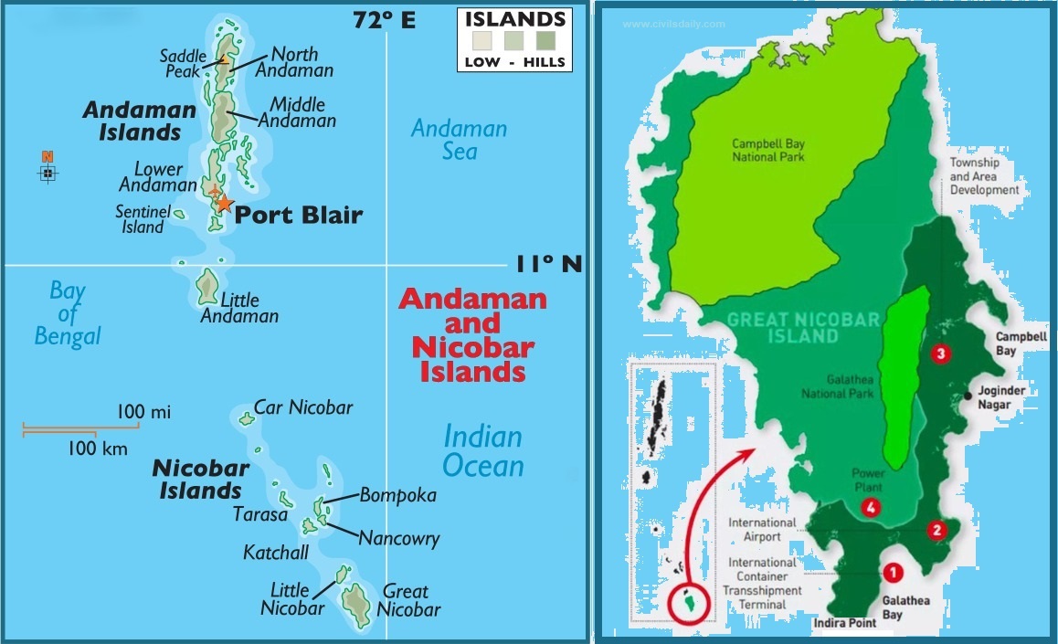
    Great Nicobar Island: An Overview

    • Geography and Ecology: Southernmost tip of India, part of the Andaman and Nicobar archipelago comprising 600-odd islands.
    • Environment: Hilly, covered with lush rainforests, annual rainfall of around 3,500 mm.
    • Biodiversity: Hosts numerous endangered and endemic species including the giant leatherback turtle, Nicobar megapode, Great Nicobar crake, Nicobar crab-eating macaque, and Nicobar tree shrew.
    • Area: 910 sq km with mangroves and Pandan forests along the coast.
    • Indigenous Communities:
      • Shompen Tribe: Approximately 250 people live in interior forests, predominantly hunter-gatherers, classified as a Particularly Vulnerable Tribal Group.
      • Nicobarese Community: Two groups – Great Nicobarese and Little Nicobarese, practice farming and fishing.
      • Resettlement: The Great Nicobarese were resettled in Campbell Bay after the 2004 tsunami.
    • Administrative Hub: Campbell Bay serves as the administrative hub, housing local offices of the Andaman and Nicobar administration and the panchayat.

    Back2Basics: “Nicobar Triangle”

    It is named after the Nicobar Islands, which are located at the northern apex of this triangular area.

    The islands within the Nicobar Triangle include:

    1. Nicobar Islands: This group of islands belongs to India and is situated to the south of the Andaman Islands. They are known for their diverse flora and fauna and are inhabited by indigenous tribes.
    2. Andaman Islands: Located to the north of the Nicobar Islands, the Andaman Islands are also part of India. They are well-known for their lush forests, coral reefs, and indigenous tribes.
    3. Indonesian Archipelago: To the south and southeast of the Nicobar Islands lies the Indonesian archipelago, which includes thousands of islands spanning a vast area between the Indian and Pacific Oceans.

    What is GNI Project?

    The GNI Project refers to the “Holistic Development of Great Nicobar Island,” a proposed mega project being piloted by NITI Aayog.

    • Implementing Agency: The project is to be implemented by the Andaman and Nicobar Islands Integrated Development Corporation (ANIIDCO).
    • Historical Context: Development plans for a port in Great Nicobar date back to the 1970s, aimed at leveraging its strategic location near the Malacca Strait.
    • The project aims to develop the southern end of the Andaman and Nicobar group of Islands in the Bay of Bengal by constructing –
    1. Transshipment port
    2. Dual-use military-civil international airport
    3. Power plant (450 MVA gas and solar-based) and
    4. A township over a span of 30 years on more than 160 sq. km of land, of which 130 sq. km is primary forest

    Features of the Project

    • Transshipment hub of the East: The proposed port will allow Great Nicobar to participate in the regional and global maritime economy by becoming a major player in cargo transshipment.
    • Naval control: The port will be controlled by the Indian Navy, while the airport will have dual military-civilian functions and will cater to tourism as well.
    • Urban amenities: Roads, public transport, water supply and waste management facilities, and several hotels have been planned to cater to tourists.

    Significance of the project

    • Economic significance: The proposed port would allow GNI to become a significant player in cargo transhipment, as it is positioned equidistant from Colombo, Port Klang (Malaysia), and Singapore.
    • Strategic significance: The proposal to develop GNI has been on the table since the 1970s, and it has been highlighted repeatedly as a crucial element for national security and consolidation of the Indian Ocean Region.
      • In recent years, the escalating Chinese presence in the Indian Ocean has added greater urgency to this imperative.

    Issues with the Project

    • The project entails the deforestation of 130 sq km, and felling 10 lakh trees, threatens biodiversity at Galathea Bay, displaces indigenous tribes, lacks thorough impact assessments, and poses seismic risks to vulnerable communities.

    Due-process Violations highlighted by the ‘Opposition’

    (1) Did not recognise the grant ownership: The island administration did not recognise or grant ownership of any forest land to local tribespeople as per FRA, a requisite step under the Forest Conservation Rules, 2017, before Stage-I clearance is granted.

    • This is despite the fact that Rule 6(3)(e) of Forest Conservation Rules-2017 (FCR) requires that any diversion of forest land first requires the District Collector to recognise and vest rights to locals under the FRA.
    • The legislation allows forest communities the right to control and manage the use of the forest land over which they hold titles, and their consent is mandatory for diverting it.

    (2) Inconsistencies with Stage-I Clearance: The Stage-I clearance for the project was granted in October 2022, two years after the application was received. Monthly progress reports show that the district administration did not process any claims over forest land under the FRA in the 26 months since project sanction.

    (3) Withdrawal of Consent: Weeks after the Stage-I clearance was granted, the Tribal Council at Campbell Bay withdrew the consent granted by the Gram Sabha.

  • Wildlife Conservation Efforts

    In news: Pobitora Wildlife Sanctuary

    Note4Students

    From UPSC perspective, the following things are important:

    Prelims level: Pobitora Wildlife Sanctuary, One-horned Rhino

    Why in the News?

    The monsoon has brought a measure of relief to animals especially the one-horned rhinoceros in Pobitora Wildlife Sanctuary dealing with extreme heat.

    About Pobitora Wildlife Sanctuary 

    • Pobitora Wildlife Sanctuary boasts the highest density of one-horned rhinos globally, second only to Kaziranga National Park in Assam.
    • Often dubbed as ‘Mini Kaziranga,’ Pobitora shares a similar landscape and vegetation to its renowned counterpart.
    • The sanctuary shelters various endangered species, including one-horned rhinoceros, leopards, leopard cats, fishing cats, jungle cats, feral buffaloes, wild pigs, and Chinese pangolins.
    • Approximately 72% of Pobitora’s area comprises a wet savannah dominated by Arundo donax and Saccharum grasses, while the rest is covered by water bodies.

    About One-Horned Rhino:

    • IUCN Red List Status: Vulnerable.
    • Habitat– Rhinos are mainly found in Assam, West Bengal and Uttar Pradesh.
      • Assam has an estimated 2,640 rhinos in four protected areas, i.e. Pobitora Wildlife Reserve, Rajiv Gandhi Orang National Park, Kaziranga National Park, and Manas National Park.

    Note: About 2,400 of them are in the Kaziranga National Park and Tiger Reserve (KNPTR).


    PYQ:

    [2019] Consider the following statements:

    1. The Asian lion is naturally found in India only
    2. Double-humped camel is naturally found in India only
    3. One-horned rhinoceros is naturally found in India only

    Which of the statements given above is/are correct?

    (a) 1 only

    (b) 2 only

    (c) 1 and 3 only

    (d) 1, 2 and 3

  • Wildlife Conservation Efforts

    In news: Nagarhole Tiger Reserve

    Note4Students

    From UPSC perspective, the following things are important:

    Prelims level: Nagarahole Tiger Reserve, Project Elephant

    Why in the News?

    • Ashwatthama, a 38-year-old elephant, died of electrocution near Karnataka’s Nagarahole Tiger Reserve.
      • The High Court of Karnataka suo motu initiated a PIL petition to inquire about this incident attributed to a lack of care and diligence by concerned authorities.

    Nagarahole Tiger Reserve

    • Located in the Western Ghats in Karnataka; Spans over 643 square kilometers.
    • Declared a wildlife sanctuary in 1955 and a tiger reserve in 1999.
    • Part of the Nilgiri Biosphere Reserve is recognised as an Important Bird Area (IBA) and a Project Tiger, Project Elephant reserve.
    • Managed by the Karnataka Forest Department with efforts focused on conservation, ecotourism, and community engagement.
    • The reserve is crisscrossed by several rivers such as the Kabini River, Lakshmana Tirtha River, and Moyar River.
      • Flora and Fauna: Known for its diverse ecosystem, including tropical and moist deciduous forests, home to a variety of wildlife such as tigers, leopards, elephants, gaur, and several species of deer and birds.

    Protective Measures: Project Elephant

    • It was launched in the year 1992 as a Centrally Sponsored Scheme with the following objectives:
      • To protect elephants, their habitat & corridors
      • To address issues of man-animal conflict
      • The welfare of captive elephants
    • It covers 23 states across India.
    • The Ministry of Environment, Forest and Climate Change provides financial and technical support to major elephant range states in the country through the project.
    • It contributed to the increase in the wild elephant population from around 25,000 in 1992 to about 30,000 in 2021.

    Status of Elephant Conservation in India

    Details
    Population Estimate
    • India hosts the largest population of wild Asian Elephants (Elephas maximus), with around 29,964 individuals,
    • Approximately 60% of the global population (2017 census).
    Leading States Karnataka holds the highest number of elephants, followed by Assam and Kerala.
    Conservation Status
    • IUCN Red List:  Endangered.
    • CMS: Appendix I.
    • Wildlife (Protection) Act, 1972: Listed under Schedule I,
    • CITES: Appendix I.


    PYQ:

    [2020] With reference to Indian elephants, consider the following statements:

    1. The leader of an elephant group is a female.
    2. The maximum gestation period can be 22 months.
    3. An elephant can normally go on calving till the age of 40 years only.
    4. Among the States in India, the highest elephant population is in Kerala.

    Which of the statements given above is/are correct?

    (a) 1 and 2 only

    (b) 2 and 4 only

    (c) 3 only

    (d) 1, 3 and 4 only

  • Historical and Archaeological Findings in News

    UNESCO heritage site of Delos, Greece

    Note4Students

    From UPSC perspective, the following things are important:

    Prelims level: Delos Monuments, World Heritage Sites, Various WHS in India

    Why in the News?

    • Delos, a UNESCO World Heritage site situated close to Mykonos, Greece, played a pivotal role as a sanctuary in the ancient Greek and Roman civilizations.
      • Scientists warn that Delos faces imminent destruction within the next 50 years due to rising sea levels caused by climate change.

    About Delos

    • Delos is a small island located in the Aegean Sea, part of the Cyclades archipelago in Greece.
    • It is considered as the birthplace of Apollo, the god of light, arts, and healing, and his sister Artemis, the goddess of the hunt.
    • Its ancient ruins date back to the 3rd millennium BCE.
    • These ruins include temples, houses, sanctuaries, theatres, and other public buildings.
    • It served as a port and trading hub, connecting the civilizations of the eastern Mediterranean with those of the west.
    • Delos was declared as a UNESCO World Heritage Site in 1990.
    • Ruins and Monuments: 
      • Some of the most notable ruins and monuments on Delos include the Terrace of the Lions, the Temple of Apollo, the House of the Dolphins, the Theater District, and the Sacred Lake.

    About UNESCO World Heritage Sites (WHS)

    Details
    Definition A WHS is a landmark or area with legal protection by an international convention administered by UNESCO.
    Criteria WHS are designated for their cultural, historical, scientific, or other forms of significance.
    World Heritage Convention
    • 1972 Convention Concerning the Protection of the World Cultural and Natural Heritage established the framework for preserving the world’s outstanding heritage.
    • 191 State Parties, including India, have ratified the World Heritage Convention.
    Number of Sites There are currently 1,172 World Heritage Sites across 166 countries.
    Types of Sites
    • 913 cultural sites
    • 220 natural sites
    • 39 mixed properties
    World Heritage Committee Evaluate nominated sites and inscribe them on the World Heritage List.
    Preservation Member states commit to protecting their World Heritage Sites.
    World Heritage Fund The fund, supported by member contributions, provides assistance for preserving sites.
    Selection Criteria Sites must demonstrate Outstanding Universal Value (OUV) by meeting criteria defined in the Convention.
    Advisory Bodies International Council on Monuments and Sites (ICOMOS) and the International Union for Conservation of Nature (IUCN) assess nominated sites.
    Criteria for Cultural Sites Six criteria for significance related to human creative genius, cultural interchange, unique testimony, outstanding examples of architecture, tradition, and events.
    Criteria for Natural Sites Four criteria for significance related to natural phenomena, Earth’s evolutionary history, ecological processes, and biological diversity.
    Legal Status Once inscribed, each site remains the property of the state it belongs to, with shared responsibility for its preservation and protection.
    Obligations Member states are obligated to integrate heritage protection into regional planning, report on-site conditions, and preserve sites for future generations.
    Enforcement The Committee may provide assistance, deploy experts, or delist sites in extreme cases of endangerment.

    Important Sites in India:

    • There are 42 World Heritage Sites in India.
    • Out of these, 34 are cultural, 7 are natural, and 1, Khangchendzonga National Park, is of mixed type.
    • India has the sixth-most sites worldwide.
    • The first sites to be listed were the Ajanta Caves, Ellora Caves, Agra Fort, and Taj Mahal, all of which were inscribed in the 1983 session of the World Heritage Committee.
    • The most recent sites listed were Santiniketan and the Sacred Ensembles of the Hoysalas, in 2023.

    PYQ:

    [2015] Which one of the following National Parks has a climate that varies from tropical to subtropical, temperate and arctic?

    (a) Khangchendzonga National Park

    (b) Nandadevi National Park

    (c) Neora Valley National Park

    (d) Namdapha National Park

  • Foreign Policy Watch: India-Iran

    India, Iran sign 10-year contract for Chabahar Port Operation

    Note4Students

    From UPSC perspective, the following things are important:

    Prelims level: Chabahar Port, Persian Gulf Mapping

    Mains level: NA

    Why in the news?

    • India and Iran signed a 10-year agreement for the operation of the Chabahar port, marking a significant milestone in their cooperation.

    Back2Basics: Chabahar Port

    • The port is located in southeastern Iran in the Sistan-Baluchistan province, on the Gulf of Oman and at the mouth of the Strait of Hormuz.
    • It is called the “Golden Gate” to Central Asian land-locked countries of Afghanistan, Turkmenistan and Uzbekistan.
    • It serves as Iran’s only oceanic port and consists of two separate ports named Shahid Kalantari and Shahid Beheshti.
    • It is only about 170 km west of the Gwadar port if Pakistan.
      • The development of Chabahar port was initiated by India with a MoU in 2015 and executed in 2016 during PM Narendra Modi’s visit to Iran.

    About the Agreement

    The contract, signed between Indian Ports Global Ltd. (IPGL) and Port and Maritime Organisation (PMO) of Iran, involves substantial investment and development initiatives.

    • IPGL will invest approximately $120 million in equipping the Shahid-Behesti terminal, enhancing the port’s efficiency and capacity.
    • India has extended a credit window of $250 million for mutually identified projects aimed at improving Chabahar-related infrastructure, emphasizing its commitment to regional development.

    Strategic Importance of Chabahar Port to India

    • Chabahar port will boost India’s access to Iran, the key gateway to the International North-South Transport Corridor that has sea, rail and road routes between India, Russia, Iran, Europe and Central Asia.
    • Chabahar port will be beneficial to India in countering Chinese presence in the Arabian Sea which China is trying to ensure by helping Pakistan develop the Gwadar port.
    • India can bypass Pakistan in transporting goods to Afghanistan.

    Economic Significance

    • Chabahar Port is at an important point on the Arabian Sea, with easy access from India’s west coast.
    • Kandla port in Gujarat is the closest port at 550 nautical miles, while the distance between Chabahar and Mumbai is 786 nautical miles.
    • Since 2019, the port has handled more than 80,000 twenty-foot equivalent units (TEUs) of container traffic and more than 8 million tonnes of bulk and general cargo.
    • The port also offers an alternative route from the Strait of Hormuz for cargo traffic between Central Asian countries and Afghanistan.

    PYQ:

    [2017] What is the importance of developing Chabahar Port by India?

    (a) India’s trade with African countries will enormously increase.

    (b) India’s relations with oil-producing Arab countries will be strengthened.

    (c) India will not depend on Pakistan to access Afghanistan and Central Asia.

    (d) Pakistan will facilitate and protect the gas pipeline installation between Iraq and India.

  • Tiger Conservation Efforts – Project Tiger, etc.

    Tiger Translocation in Sahyadri-Konkan Wildlife Corridor  

    Note4Students

    From UPSC perspective, the following things are important:

    Prelims level: Sahyadri-Konkan Wildlife Corridor, Tadoba-Andhari TR

    Mains level: NA

    Why in the news?

    Maharashtra’s plan to increase tigers count in Sahyadri-Konkan Wildlife Corridor by translocating tigers from Tadoba-Andhari Tiger Reserve (TATR) (Chandrapur, Maharashtra) underscores the critical role of wildlife corridors in conservation efforts.

    About Tadoba-Andhari Tiger Reserve (TATR)

    • Tadoba became one of India’s earliest national parks when it was declared in 1955, alongside Kanha National Park.
    • The name “Tadoba” is derived from the deity “Tadoba” or “Taru,” worshipped by local Gond Tribals, and “Andhari” refers to the Andhari River flowing through the reserve.
    • It was later expanded and officially merged with the Andhari Wildlife Sanctuary in 1993 to form the TATR.
    • TATR is regarded as one of the world’s most preferred destinations for tiger sightings and is a critical part of Project Tiger, aimed at conserving tigers in India.
    • The reserve has 115 tigers, including 88 within the forest and 27 in the areas immediately surrounding the reserve.

    About Sahyadri-Konkan Wildlife Corridor  

    • The Sahyadri-Konkan corridor (Sahyadri-Radhanagari-Goa-Karnataka), plays a vital role in conserving wildlife, particularly tigers, in the northern Western Ghats region.
    • It spans throughout the states of Maharashtra, Goa, and Karnataka, specifically through the Western Ghats, one of the world’s eight biodiversity hotspots.
    • Protected Areas Connected:
    1. Sahyadri Tiger Reserve (includes Koyna Wildlife Sanctuary (WLS) and Chandoli National Park) and Radhanagari Wildlife Sanctuary (Maharashtra);
    2. Bhimgad Wildlife Sanctuary and Kali Tiger Reserve (includes Anshi National Park and Dandeli WLS) in (Karnataka);
    3. Mollem National Park, Netravali Wildlife Sanctuary (Goa).
    • Fauna: Tiger (Panthera tigris), Indian leopard (Panthera pardus), dhole (Cuon alpinus), and sloth bear (Melursus ursinus), etc.
    • The Western Ghats, including parts of the corridor, are designated as a UNESCO World Heritage Site in 2012 due to their outstanding universal value in terms of biodiversity and endemic species.

    PYQ:

    [2020] Among the following Tiger Reserves, which one has the largest area under “Critical Tiger Habitat”?

    (a) Corbett

    (b) Ranthambore

    (c) Nagarjunsagar-Srisailam

    (d) Sunderbans

  • Wildlife Conservation Efforts

    Mapping: Garo Hills

    Note4Students

    From UPSC perspective, the following things are important:

    Prelims level: Garo Hills

    Mains level: NA

    Why in the news?

    • Geological Survey of India (GSI) explorers have made a breakthrough, uncovering ancient fossils in Tolegre, South Garo Hills of Meghalaya.
    • It is speculated that the fossils could be linked to the genera Rhodocetus or Amulocetus (now extinct), considered ancestors of modern whales.

    About Garo Hills

    • The Garo Hills, located in Meghalaya, are part of the Garo-Khasi range, one of the hill ranges in the northeastern region of India.
    • They are situated in the western part of Meghalaya, bordering Bangladesh to the south and west.
    • The terrain of the Garo Hills is rugged and hilly, characterized by dense forests, steep slopes, and deep valleys.
    • The Nokrek is highest Peak, which stands at approximately 1,415 meters (4,642 feet) above sea level.
    • The climate in the Garo Hills is typically humid subtropical, with heavy rainfall during the monsoon season, which usually lasts from June to September.
    • Numerous rivers and streams, including the Brahmaputra, Someshwari, and Jinjiram rivers crisscross this region.
    • The region is also known for its picturesque waterfalls, such as the Pelga Falls, located near Tura, the largest town in the Garo Hills.
    • The Nokrek National Park, located within, is recognized as a UNESCO Biosphere Reserve and is home to various endangered species, including the Asian elephant and the red panda.
    • The Garo Hills are inhabited predominantly by the Garo tribe, one of the major ethnic groups in Meghalaya.


    PYQ:

    [2013] Consider the following pairs:

    1. Nokrek Bio-Sphere Reserve : Garo Hills

    2. Logtak (Loktak) Lake : Barail Range

    3. Namdapha National Park: Daphla Hills

    Which of the above pairs is/are correctly matched?

    (a) 1 only

    (b) 2 and 3 only

    (c) 1, 2 and 3

    (d) None

  • Climate Change Impact on India and World – International Reports, Key Observations, etc.

    Why the Thar Desert on the borders of India and Pakistan is getting greener?

    Note4Students

    From UPSC perspective, the following things are important:

    Prelims level: Thar Desert, Desert National Park;

    Mains level: NA

    Why in the News?

    Rajasthan’s barren Thar Desert may turn green, says a recent study in the journal Earth’s Future.

    Thar Desert

    • The Thar Desert is the 18th largest subtropical desert globally and is one of the most densely populated deserts.
    • Approximately 40% of the human population in Rajasthan resides in the Thar Desert.
    • It extends from the Sutlej River and is bounded by the Rann of Kutch, the Aravalli Mountains, and the Indus River.
    • About 85% of the Thar Desert is located in India, with the remainder in Pakistan.
    • In India, it spans across Rajasthan, Gujarat, Haryana, and Punjab as well.
    • Civilizations are believed to have thrived in the Thar region around 50,000 years ago across the extinct Saraswati River.
    • The Desert National Park (home to the endangered Great Indian Bustard, desert fox, desert cat, blackbuck, and Indian gazelle) is situated in the Thar Desert in the northwest Indian state of Rajasthan.

    Why is the Thar desert getting greener?

    • Climate Change Effects:
        • Alteration of Weather Patterns: Climate change is causing shifts in rainfall distribution in the thar desert area.
        • Potential for Vegetation Growth: The increased precipitation could provide favorable conditions for vegetation growth, contributing to the greening of the desert.
    • Indian Monsoon Dynamics:
        • Westward Extension of Indian Monsoon: The Indian monsoon, known for bringing heavy rainfall to eastern India, is now extending further westward into regions like the Thar Desert.
        • Impact on Moisture and Rainfall: This change in monsoon dynamics could lead to increased moisture and rainfall in the desert region, facilitating the growth of vegetation.
    • Expansion of Indian Ocean Warm Pool (IOWP):
        • Influence on Monsoon Patterns: The Indian Ocean Warm Pool (IOWP) influences monsoon patterns and rainfall distribution over the Indian subcontinent.
        • Westward Expansion due to Climate Change: Climate change is causing the IOWP to expand westward, potentially resulting in increased rainfall over semi-arid regions like the Thar Desert and promoting greening.
    • Water Management Practices:
        • Contribution to Greening: Effective water management practices, such as rainwater harvesting and irrigation techniques like johad, kuis, and kunds, may be playing a role in the greening of the Thar Desert.
        • Utilization of Water Resources: By harnessing and efficiently utilizing available water resources, local communities and authorities can support vegetation growth and ecosystem restoration efforts in the desert.
    • Introduction of Irrigation  
      • Commercial Cropping: Irrigation was introduced during British colonial rule in the 19th and 20th centuries to convert arid and semi-arid ecosystems into cropland.
      • Restrictions on Grazing: The right to graze animals was restricted to landowners who cultivated crops, leading to the transformation of nomadic pastoralists into sedentary agro-pastoralists.

    PYQ:

    [2018] Which of the following leaf modifications occur(s) in the desert areas to inhibit water loss?

    1. Hard and waxy leaves
    2. Tiny leaves
    3. Thorns instead of leaves

    Select the correct answer using the code given below:

    (a) 2 and 3 only

    (b) 2 only

    (c) 3 only

    (d) 1, 2 and 3

    [2020] The process of desertification does not have climate boundaries. Justify with examples.

    [2013] Major hot deserts in northern hemisphere are located between 20-30 degree north and on the western side of the continents. Why?

  • Wetland Conservation

    In the news: Pulicat Wetland

    Note4Students

    From UPSC perspective, the following things are important:

    Prelims level: Pulicat Wetland and its topography; Eco-sensitive Zones (ESZs)

    Mains level: NA

    Why in the news?

    • Settlement of claims for local communities within Pulicat Wetland and Birds Sanctuary boundary raises concerns.
    • State government plans to denotify a significant portion of the sanctuary and Eco-Sensitive Zone (ESZ) for industrial park development.

    About Pulicat Wetland and Birds Sanctuary

    • Pulicat Lake Bird Sanctuary is the second-largest bird sanctuary in India.
    • It cuts across Nellore district of Andhra Pradesh and Thiruvallur district of Tamil Nadu.
    • The sanctuary is situated along the coast of the Bay of Bengal covering an area of 759 square kilometers.
    • The sanctuary is bordered by the Arani River at its southern tip, the Kalangi River from the Northwest, and the Swarnamukhi River at the northern end.
    • Pulicat Lake runs parallel to the Bay of Bengal and has a sand bar, making it a lagoon of its own kind.
    • Sriharikota, renowned as India’s rocket launch pad and home to the Satish Dhawan Space Centre, separates the lake from the Bay of Bengal.
    • The sanctuary includes 16 island villages and 30 villages adjoining the lake, whose inhabitants depend on the lake for their livelihood.
    • Pulicat Lake Bird Sanctuary hosts a large number of migratory birds during winter, including gulls, terns, plovers, shanks, curlews, and storks.
    • It is a habitat for a variety of bird species such as flamingos, pelicans, storks, herons, and ducks.

    What are the Eco-sensitive Zones (ESZs)?

    •  Eco-Sensitive Zones (ESZs) or Ecologically Fragile Areas (EFAs) are areas notified by the MoEFCC around Protected Areas, National Parks and Wildlife Sanctuaries.
    • The purpose of declaring ESZs is to create some kind of “shock absorbers” to the protected areas by regulating and managing the activities around such areas.
    • They also act as a transition zone from areas of high protection to areas involving lesser protection.

     How are they demarcated?

    • The Environment (Protection) Act, 1986 does NOT mention the word “Eco-Sensitive Zones”.
    • However, Section 3(2)(v) of the Act, says that Central Government can restrict areas in which any industries, operations or processes or class of industries, operations or processes shall be carried out or shall not, subject to certain safeguards.
    • Besides Rule 5(1) of the Environment (Protection) Rules, 1986 states that central government can prohibit or restrict the location of industries and carrying on certain operations or processes on the basis of certain considerations.
    • The same criteria have been used by the government to declare No Development Zones (NDZs).

    Defining its boundaries

    • An ESZ could go up to 10 kilometres around a protected area as provided in the Wildlife Conservation Strategy, 2002.
    • Moreover, in the case where sensitive corridors, connectivity and ecologically important patches, crucial for landscape linkage, are beyond 10 km width, these should be included in the ESZs.
    • Further, even in the context of a particular Protected Area, the distribution of an area of ESZ and the extent of regulation may not be uniform all around and it could be of variable width and extent.


    PYQ:

     [2017] Consider the following statements:

    1. In India, the Himalayas are spread over five States only.

    2. Western Ghats are spread over five States only.

    3. Pulicat Lake is spread over two States only.

    Which of the statements given above is/are correct?

    (a) 1 and 2 only

    (b) 3 only

    (c) 2 and 3 only

    (d) 1 and 3 only

  • Global Geological And Climatic Events

    Mount Ruang in Indonesia Erupts

    Note4Students

    From UPSC perspective, the following things are important:

    Prelims level: Mount Ruang, Pacific Ring of Fire, Sangihe Islands arc, Tectonic Plates mentioned

    Mains level: NA

    Why in the news?

    Indonesia witnessed a series of eruptions from Mount Ruang, a stratovolcano located in North Sulawesi Province.

    About Mount Ruang 

    • Ruang is situated in the Sangihe Islands arc, North Sulawesi, Indonesia.
    • It comprises an island that is 4 by 5 kilometers wide, with a summit containing a partial lava dome reaching an altitude of 725 meters (2,379 ft).
    • From its summit, peaks such as Klabat, Siau, and Ternate can be observed in the south, north, and east, respectively.
    • The volcano’s first recorded eruption was in 1808.

    Why so many volcanic eruptions in Indonesia this year?

    • Indonesia, an archipelago of 270 million people, has 120 active volcanoes.
    • It is prone to volcanic activity because it sits along the “Ring of Fire,” a horseshoe-shaped series of seismic fault lines around the Pacific Ocean.

    What is the Pacific ‘Ring of Fire’?

    • The Pacific ‘Ring of Fire’ or Pacific Rim, or the Circum-Pacific Belt, is an area along the Pacific Ocean that is characterized by active volcanoes and frequent earthquakes.
    • Volcanic arcs and oceanic trenches partly encircling the Pacific Basin form the so-called Ring of Fire.
    • It is home to about 75 per cent of the world’s volcanoes – more than 450 volcanoes.
    • Also, about 90 per cent of the world’s earthquakes occur here.

    Its spread

    • Its length is over 40,000 kilometres and traces from New Zealand clockwise in an almost circular arc covering Tonga, Kermadec Islands, Indonesia.
    • It is moving up to the Philippines, Japan, and stretching eastward to the Aleutian Islands, then southward along the western coast of North America and South America.

    Seismic activity of the region

    • The area is along several tectonic plates including the:
    1. Pacific plate,
    2. Philippine Plate,
    3. Juan de Fuca plate,
    4. Cocos plate,
    5. Nazca plate, and
    6. North American plate.
    • The movement of these plates or tectonic activity makes the area witness abundant earthquakes and tsunamis every year.
    • Along much of the Ring, tectonic plates move towards each other creating subduction zones.

    PYQ:

    [2018] Consider the following statements:

    1. The Barren Island volcano is an active volcano located in the Indian Territory.
    2. Barren Island lies about 140 km east of Great Nicobar.
    3. The last time the Barren Island volcano erupted was in 1991 and it has remained inactive since then.

    Which of the statements given above is/are correct?

    (a) 1 only

    (b) 2 and 3

    (c) 3 only

    (d) 1 and 3