💥UPSC 2026, 2027, 2028 UAP Mentorship (March Batch) + Access XFactor Notes & Microthemes PDF

Type: Prelims Only

  • Climate Change Impact on India and World – International Reports, Key Observations, etc.

    Coral Loss in Lakshadweep

    Why in the News?

    A 24-year-long study conducted by the Nature Conservation Foundation reveals that coral cover in Lakshadweep has declined by 50% since 1998.

    Coral Decline in Lakshadweep: Key Highlights

    • Study Duration: Based on a 24-year study (1998–2022).
    • Findings: 50% decline in live coral cover—from 37.2% to 19.6%.
    • Main Cause: Repeated marine heatwaves linked to climate change.
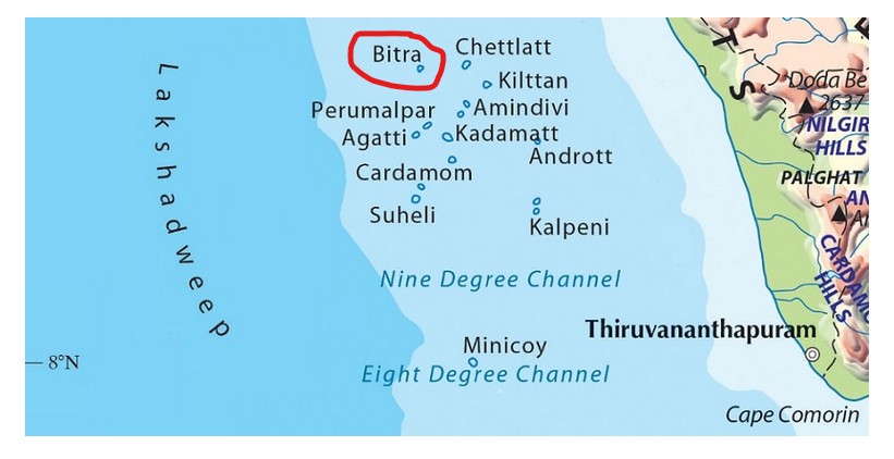
    • Study Locations: Monitored across Agatti, Kadmat, and Kavaratti atolls.
    • Response Clusters: Six coral groups identified based on:
      • Depth and wave exposure
      • Heat resistance and recovery patterns
    • Recovery Timeline: Requires at least 6 years without bleaching for healthy regeneration.

    Back2Basics: Corals and Coral Bleaching:

    • About: Corals are colonies of tiny animals called polyps, which build calcium carbonate skeletons.
    • Symbiotic Algae: Host zooxanthellae, microscopic algae that provide nutrients via photosynthesis.
    • Coral Types:
      • Hard Corals: Form reef structures (e.g., brain coral, staghorn coral).
      • Soft Corals: Flexible, grow on reef surfaces but do not build reefs.
    • Habitat Requirements:
      • Water Quality: Must be clean and low in sediment.
      • Temperature Range: Prefer 20–21°C.
      • Depth: Typically found in waters less than 90 metres deep.
      • Salinity: Optimal range is 27–30 parts per thousand (ppt).
      • Ocean Currents: Require nutrient-rich water flow.
    • Coral Bleaching:
      • Cause: Triggered by heat stress, pollution, or acidification, which drive algae out.
      • Effect: Coral turns white due to loss of algae; Loses its main food source. Dies if stress persists for long periods.
    [UPSC 2022] “Biorock Technology” is talked about in which one of the following situations?

    Options: (a) Restoration of damaged coral reefs * (b) Development of building materials using plant residues (c) Identification of areas for exploration/extraction of shale gas  (d) Providing salt licks for wild animals in forests


  • Modern Indian History-Events and Personalities

    Paika Rebellion references omitted from NCERT books

    Why in the News?

    Former Odisha CM expressed concern over the omission of the Paika Rebellion from NCERT’s latest Class VIII history textbook, calling it a “huge dishonour” to the brave Paikas.

    Localized Revolts in Odisha Region:

    • The Paika Rebellion was part of a broader pattern of regional uprisings triggered by colonial encroachments:
      • Paralakhemundi Rebellion (1799–1814)
      • Ghumusar Revolt (1835–36)
      • Angul Uprising (1846–47)
      • Kondh and Sabara Rebellions (1855–1857)
    • These revolts were often led by dispossessed elites and tribal communities, reacting to land loss, economic distress, and erosion of traditional authority.

    About Paika Rebellion:

    • Who Were the Paikas: Traditional militia of Odisha who served local kings in exchange for rent-free land (nish-kar jagirs) and social standing.
    • Role: Functioned as hereditary foot soldiers and police for the Khurda kingdom.
    • Decline: British annexation of Odisha in 1803 ended their privileges through land revenue reforms and colonial restructuring.
    • Leader: Led by Bakshi Jagabandhu Bidyadhar, the military chief under King Mukunda Dev II of Khurda.
    • Causes of Rebellion: Loss of land rights, oppressive taxation, and marginalization of both the elite and peasantry under British rule.
    • Key Events:
      • 2 April 1817: Bakshi Jagabandhu led the Paikas, joined by tribal Kondhs and others, in open rebellion.
      • Rebel Actions: British offices at Banapur were torched, the treasury looted, and colonial officers killed.
      • British Response: Regained control by mid-1817, but rebels resorted to guerrilla tactics.
      • Bakshi’s Death: Captured in 1825, died in custody in 1829.

    Outcomes:

    • British Concessions: Temporary tax remissions, Lowered assessments, Suspended forced estate sales and fixed-land-tenures.
    • Administrative Impact: These measures showed the British were forced to reconsider exploitative policies.
    • Aftermath and Significance:
      • Historical Role: An early example of organized resistance against British colonial rule—decades before 1857.
      • Freedom Struggle Legacy: Viewed as a precursor to India’s independence movement.
      • Current Demand: Odisha leaders advocate its recognition as India’s “first war of independence.”
    [UPSC 2018] After the Santhal Uprising subsided, what was/were the measure/measures taken by the colonial government?

    1. The territories called `Santhal Paraganas’ were created. 2. It became illegal for a Santhal to transfer land to a non-Santhal.

    Select the correct answer using the code given below:

    Options: (a) 1 only (b) 2 only (c) Both 1 and 2* (d) Neither 1 nor 2


  • Climate Change Impact on India and World – International Reports, Key Observations, etc.

    Towards Resilient and Prosperous Cities in India: World Bank Report (2024)

    Why in the News?

    The World Bank’s report, “Towards Resilient and Prosperous Cities in India”, warns that climate risks like extreme heat and floods threaten India’s cities, despite their role as economic growth engines.

    About the ‘Towards Resilient and Prosperous Cities in India’ Report

    • Prepared By: World Bank in collaboration with the Ministry of Housing and Urban Affairs
    • Focus: Evaluates Indian cities’ exposure to climate risks like heatwaves and urban flooding
    • Scope: Covers 24 cities with deeper analysis of Chennai, Indore, New Delhi, Lucknow, Surat, and Thiruvananthapuram
    • Support: Backed by Global Facility for Disaster Reduction and Recovery (GFDRR)

    Key Highlights:

    • Urban Growth:
      • 70% of new jobs to emerge in urban areas by 2030
      • Urban population to nearly double to 951 million by 2050
      • Estimated housing demand: 144 million new homes by 2070
    • Climate Vulnerabilities:
      • Urban heat: City temperatures rising by 3–4°C due to the heat island effect
      • Flood risk: Rapid construction limiting natural drainage and stormwater absorption
    • Investment Needs: $2.4 trillion required by 2050 for low-carbon, climate-resilient infrastructure
    • Recommendations:
      • Promote cool roofs, urban green spaces, and early warning systems
      • Invest in energy-efficient housing, flood-resilient transport, and waste systems
      • Strengthen urban financial systems and incentivize private participation

    Back2Basics: World Bank

    • Overview: A global development organisation supporting economic progress in developing nations
    • Founded: 1944 at the Bretton Woods Conference
    • Headquarters: Washington, D.C., United States
    • Members: 189 countries
    • India and the WB:
      • India is a founding member of the IBRD and currently participates in four out of the five World Bank Group entities.
      • India’s first World Bank loan, in 1948, was for railway rehabilitation.
    • Constituent Institutions:
      • IBRD – International Bank for Reconstruction and Development
      • IDA – International Development Association
      • IFC – International Finance Corporation
      • MIGA – Multilateral Investment Guarantee Agency
      • ICSID – International Centre for Settlement of Investment Disputes
    • Key Reports:
      • World Development Report
      • Global Economic Prospects
      • Ease of Doing Business Index (now replaced)
      • Business Ready (B-READY)


    [UPSC 2025] The World Bank warned that India could become one of the first places where wet-bulb temperatures routinely exceed 35°C. Which of the following statements best reflect(s) the implication of the above-said report?

    I. Peninsular India will most likely suffer from flooding, tropical cyclones and droughts. II. The survival of animals including humans will be affected as shedding of their body heat through perspiration becomes difficult.

    Select the correct answer using the code given below.

    Options: (a) I only (b) II only* (c) Both I and II (d) Neither I nor II


  • Foreign Policy Watch: India-China

    China commences construction of Mega Dam over Brahmaputra

    Why in the News?

    China has commenced the construction of a massive hydropower project on the Yarlung Tsangpo river (Brahmaputra in India) in southeastern Tibet.

    China commences construction of Mega Dam over Brahmaputra

    About the Mega Dam Project on Brahmaputra (Yarlung Tsangpo):

    • Location: Nyingchi, southeastern Tibet, on the Yarlung Tsangpo River (Brahmaputra in India).
    • Project Size: Estimated investment of 1.2 trillion yuan (USD 167 billion).
    • Components: Comprises five cascade hydropower stations.
    • Power Generation: Expected to produce 300 billion kilowatt-hours (kWh) of electricity annually.
    • Objective:
      • Contribute to China’s carbon neutrality target by 2060.
      • Meet local power needs in Tibet and supply electricity to other Chinese provinces.
    • Concerns:
      • Environmental risks in a seismically active and ecologically fragile zone.
      • Geopolitical tensions with downstream countries (India, Bangladesh).
      • Potential impact on river flow and water availability downstream.
    • Strategic Significance: Close to India-China border, raising concerns amid existing border disputes.

    What if China stops Brahmaputra Water? 

    You should know: Three Gorges Dam 

    • Location: On the Yangtze River, Hubei province, central China.
    • Completed: Fully operational since 2012.
    • Type: Hydroelectric gravity dam – the world’s largest power station by installed capacity.
    • Power Generation Capacity: Around 22.5 gigawatts (GW).
    • Notable Impact:
      • Helped in flood control, navigation, and electricity supply.
      • Also criticized for ecological damage, displacement of over 1 million people, and increased seismic risk.


    [UPSC 2011] The Brahmaputra, Irrawady and Mekong rivers originate in Tibet and flow it through narrow and parallel mountain ranges in their upper reaches. Of these rivers, Brahmaputra makes a “U” turn in its course to flow into India. This “U” turn is due to:

    (a) Uplift of folded Himalayan series

    (b) Syntaxial bending of geologically young Himalayas

    (c) Geo-tectonic disturbance in the tertiary folded mountain chains

    (d) Both (A) and (B) above


  • Places in news: Bitra Island

    Why in the News?

    The Lakshadweep administration has proposed the acquisition of Bitra Island, the smallest inhabited island in the archipelago, for national defence purposes.

    bitra

    About Bitra Island:

    • Location: Situated in the Arabian Sea; part of the Amindivi subgroup of the Lakshadweep archipelago
    • Distance from Mainland: ~483 km west of Kochi  
    • Land Area: 0.10–0.18 square kilometres
    • Population: ~271–350 (as of 2025)
    • Language and Livelihood
      • Languages Spoken: Malayalam, Mahl, and English
      • Economic Activities: Fishing, coconut farming, and emerging ecotourism (birdwatching, snorkeling, diving)
    • Climate:
      • Type: Tropical monsoon (similar to Kerala)
      • Temperature Range: 25–35°C
      • Annual Rainfall: ~1600 mm
      • Monsoon Season: Mid-May to mid-September; sea access is limited
    • Historical and Cultural Significance:
      • History: Populated around 1945
      • Pilgrimage Site: Hosts a shrine to Arab saint Malik Mulla

    Strategic Importance:

    • Location: Close to key international shipping lanes in the Arabian Sea
    • Surveillance Advantage: Ideal point for maritime monitoring
    • Military Utility: Suitable for naval installations and coastal defence
    • Maritime Awareness: Enhances India’s preparedness in the western seaboard
    [UPSC 2014] Which one of the following pairs of islands is separated from each other by the ‘Ten Degree Channel’?

    Options: (a) Andaman and Nicobar* (b) Nicobar and Sumatra (c) Maldives and Lakshadweep (d) Sumatra and Java


  • Defence Sector – DPP, Missions, Schemes, Security Forces, etc.

    Javelin Anti-Tank Guided Missiles (ATGMs)

    Why in the News?

    India has formally submitted a Letter of Request (LoR) to the United States seeking the co-production of Javelin anti-tank guided missiles (ATGMs) under the ‘Make in India’ initiative.

    Javelin Anti-Tank Guided Missiles (ATGMs)

    About the Javelin Missile:

    • About: American-made man-portable anti-tank guided missile (ATGM).
    • Developers: Jointly developed by Raytheon and Lockheed Martin.
    • Purpose:
      • Defeats heavily armoured vehicles such as main battle tanks.
      • Effective against bunkers, fortifications, and helicopters.
    • Operational Since: Entered service with the U.S. military in 1996.

    Key Features:

    • Range:
      • Standard effective range: 2.5 km.
      • Advanced variants: Can reach up to 4 km.
    • Weight: Approximately 5.11 kg.
    • Technology:
      • Employs a “fire-and-forget” system.
      • No need for operator guidance after launch.
    • Target Engagement Modes:
      • Direct attack mode: For conventional engagement.
      • Top-attack mode: Hits the weaker top armour of tanks.
    • Mobility & Safety:
      • Soldiers can relocate or reload immediately after launch.
      • Uses infrared guidance allowing quick post-launch cover.
    [UPSC 2018] What is “Terminal High Altitude Area Defense (THAAD)”, sometimes seen in the news?

    Options: (a) An Israeli radar system (b) India’s indigenous anti-missile programme (c) An American anti-missile system* (d) A defence collaboration between Japan and South Korea


  • Climate Change Impact on India and World – International Reports, Key Observations, etc.

    Wind Stilling Effect in the Indo-Gangetic Plain (IGP)

    Why in the News?

    A satellite-based study (2003–2020) of 141 Indian cities revealed a surprising aerosol pattern — southern cities act as pollution hotspots, while many northern cities form ‘clean islands’ due to a phenomenon called the Wind Stilling Effect.

    Key Highlights of the Study:

    • Conducted by: The Indian Institute of Technology Bhubaneswar.
    • Method: Used high-resolution aerosol optical depth data to track pollution.
    • Focus: Examined how urbanisation interacts with natural and transported pollution.
    • Surprising Insight: Many northern cities were not major aerosol hotspots, contrary to assumptions.
    • Classification of Cities: Two categories based on aerosol levels relative to surrounding areas:
      • Urban Aerosol Pollution Islands-
        • Location: Predominantly in southern and southeastern India.
        • Characteristics: Cities had higher aerosol levels than nearby rural surroundings.
        • Pollution Source: Mostly local emissions from vehicles, construction, and industries.
        • Absence of External Influence: Minimal contribution from long-range dust or biomass burning.
      • Urban Aerosol Clean Islands-
        • Location: Observed in northwestern India and the Indo-Gangetic Plain.
        • Pattern: Cities had lower aerosol levels than nearby upwind (southwest) areas.
        • Mechanism: Incoming pollutants were blocked or deflected, creating a “clean island” effect.
        • Downwind Evidence: Northeast (downwind) sides showed equal or lower aerosol levels compared to city centres.

    About the Wind Stilling Effect:

    • Overview: A phenomenon where dense urban infrastructure reduces surface wind speed, altering local airflow.
    • Barrier Formation: Slowed winds create atmospheric stagnation zones, especially on the upwind side.
    • Pollution Blocking: Long-range pollutants like Thar Desert dust or biomass smoke are slowed or blocked.
    • Misleading Cleanliness: Cities appear cleaner not due to lower emissions, but due to pollution deflection.
    • Seasonality: Most evident during the pre-monsoon season, when dust transport is high and cloud cover is minimal.
    [UPSC 2010] If there were no Himalayan ranges, what would have been the most likely geographical impact on India ?

    1. Much of the country would experience the cold waves from Siberia. 2. Indo-gangetic plain would be devoid of such extensive alluvial soils. 3. The pattern of monsoon would be different from what it is at present.

    Which of the statements given above is/are correct ?

    Options: (a) 1 only (b) 1 and 3 only (c) 2 and 3 only (d) 1, 2 and 3*


  • International Space Agencies – Missions and Discoveries

    Planetary Formation observed around HOPS‑315 Star

    Why in the News?

    A study in Nature has provided the first observational evidence of solid rock forming from vapour in a distant star system HOPS-315, marking early planet formation.

    About HOPS-315:

    • Type: A young star system located in the Orion constellation.
    • Protoplanetary Disc: Surrounded by a flat, rotating disc of gas and dust, where new planets can form.
    • Orientation: The disc’s tilt offers a clear line of sight from Earth, allowing deep observation.
    • Observational Tools:

    Clue on New Planet Formation:

    • Rock Vapour Crystallisation: Scientists captured rock vapour cooling and forming crystals, marking the first direct observation of solid matter forming around a star.
    • Detected Elements:
      • Silicon monoxide gas at 470 Kelvin, close to the star.
      • Crystalline silicates such as forsterite, enstatite, and silica found within 2.2 astronomical units of the star.

    Scientific Significance:

    • Similarity to Earth: The crystallisation mimics processes found in primitive meteorites on Earth.
    • Chemical Confirmation: Suggests universal chemical processes in early planet formation across star systems.
    • Location of Minerals: Crystals were detected in the disc’s atmosphere, not in stellar outflows.
    • Temperature Conditions: Simulations confirmed dust vaporises and re-forms into solids at around 1300 Kelvin.
    • Formation Stage: Marks the earliest stage of rocky planet formation ever observed.
    [UPSC 2015] The term ‘Goldilocks Zone’ is often seen in the news in the context of-

    Options: (a) the limits of habitable zone above the surface of the Earth (b) regions inside the Earth where shale gas is available (c) search for the Earth-like planets in outer space* (d) search for meteorites containing precious metals


  • Historical and Archaeological Findings in News

    [pib] Ashokan Pillars of Rampurva and Lauriya Nandangarh

    Why in the News?

    A replica of the Ashoka Pillar was unveiled at Waskaduwa Sri Subhuthi Viharaya highlighting Buddhism in Sri Lanka.

    The original pillars, like those at Rampurva and Lauriya Nandangarh in Bihar, are key symbols of India’s Buddhist and Mauryan heritage and are on UNESCO’s Tentative List.

    [pib] Ashoka Pillars of Rampurva and Lauriya Nandangarh

    About Rampurva Ashoka Pillars (West Champaran, Bihar):

    • Location: Near the Nepal border in West Champaran district, Bihar.
    • Discovery: Found by archaeologist Alexander Cunningham, Lamb Carlleyle in 1876.
    • Pillars: Two monolithic sandstone pillars, 300 meters apart:
      • Lion Capital Pillar: Contains Major Pillar Edicts I–VI in Brahmi script.
      • Bull Capital Pillar: Known for artistic refinement and Persian-inspired motifs.
    • Design Features:
      • Polished sandstone with Mauryan craftsmanship.
      • Height: 12–15 meters; Weight: Up to 50 tons.
      • Lion Capital: Preserved at Indian Museum, Kolkata.
      • Bull Capital: Housed at Rashtrapati Bhavan, New Delhi; praised for its lifelike form and “velvet touch” finish.
      • Decorative motifs include rosette, palmette, and acanthus—showing Persian influence.
    • Legend: Marks the site of Buddha’s renunciation near the Anoma River.

    About Lauriya Nandangarh Ashoka Pillar (West Champaran, Bihar):

    • Location: 22–28 kilometers northwest of Bettiah town.
    • Surviving Structure: Only one complete pillar remains from an original group.
    • Material and Size:
      • Made of Chunar sandstone.
      • Stands about 12 meters above ground with ~3 meters underground; Weighs over 50 tons.
    • Capital Design:
      • Features a seated lion with hind legs extending beyond the abacus.
      • The abacus is adorned with hamsa (flying geese), symbolizing spiritual liberation.
    • Inscriptions:
      • Engraved with Major Pillar Edicts I–VI in Brahmi script, dated to 244 BCE.
      • Promotes dharma, non-violence, religious tolerance, and compassion.
    • Symbolism:
      • The lion capital represents Mauryan imperial strength and Buddha’s Sakya lineage.
      • The lion’s open mouth symbolizes the dissemination of Ashoka’s ethical and Buddhist teachings.
    [UPSC 2019] In which of the following relief sculpture inscriptions is ‘Ranyo Ashoka’ (King Ashoka) mentioned along with the stone portrait of Ashoka?

    Options: (a) Kanganahalli* (b) Sanchi I (c) Shahbazgarhi (d) Sohgaura


  • Air Pollution

    [pib] 10 years of Winter Fog Experiment (WiFEX)

    Why in the News?

    The Winter Fog Experiment (WiFEX) at Delhi’s IGI Airport, has marked 10 years of pioneering research on dense winter fog in North India.

    [pib] 10 years of Winter Fog Experiment (WiFEX)

    About Winter Fog Experiment (WiFEX):

    • Purpose: It is a long-term, open-field research project dedicated to studying winter fog—a major hazard in North India.
    • Launch: Initiated in 2015 at Indira Gandhi International Airport, New Delhi.
    • Lead Institution: Managed by the Indian Institute of Tropical Meteorology (IITM) under the Ministry of Earth Sciences.
    • Supporting Agencies: Supported by the India Meteorological Department (IMD) and the National Centre for Medium Range Weather Forecasting.
    • Objective: To understand fog variability, dynamics, and microphysics, and to improve fog forecasting across the Indo-Gangetic Plain.

    Key Features:

    • Network: Began at Indira Gandhi International Airport; expanded to Jewar Airport (Noida) and Hisar (Haryana).
    • Instruments Used: Includes micrometeorology towers, ceilometers, and high-frequency sensors.
    • Data Collected: Covers temperature profiles, humidity, wind, turbulence, soil heat flux, and aerosol concentrations.
    • Scientific Goal: To model the full fog life cycle and develop operational forecasting systems.
    • Next Phase – WiFEX-II:
      • Will provide localized, runway-specific fog forecasts.
      • Will expand to more airports for real-time winter decision-making.

    Outcomes:

    • Forecasting Model: A high-resolution fog prediction model with 3-km resolution and 85% accuracy for very dense fog (visibility <200 metres).
    • Operational Benefits: Reduced flight delays and diversions; enhanced runway safety.
    • Research Insights: Clarified the role of air pollution, urban heat islands, and land-use changes in fog formation.
    • Significance:
      • Aviation Planning: Helps airlines, pilots, and passengers manage winter fog disruptions.
      • Science-Policy Link: Demonstrates successful collaboration between scientific institutions and public policy to address climate and aviation challenges.
    [UPSC 2014] Photochemical smog is a resultant of the reaction among-

    Options: (a) NO2, O3 and peroxyacetyl nitrate in the presence of sunlight ** (b) CO2, O2, and peroxyacetyl nitrate in the presence of sunlight (c) CO, CO2, and NO2 at low temperature (d) high concentration of NO2, O3 and CO in the evening