From UPSC perspective, the following things are important :
Prelims level: Flashpoint Reef
Why in the News?
China reasserted its claim over Flashpoint Reef (the Scarborough Shoal) in the South China Sea following Philippines’ establishment of defined sea boundaries.
Do you know?
Fiery Cross Reef is a rock located in the Spratly Islands. China first took possession of the feature in 1988.
Mischief Reef is a Low-Tide Elevation (LTE) within the Philippines’ EEZ. It is part of the submerged continental shelf of the adjacent coastal state, which is the Philippines.
About the Flashpoint Reef
It generally refers to Scarborough Shoal, a contested reef in the South China Sea.
Known as Huangyan Dao in China, this reef has become a focal point of territorial disputes between China and the Philippines.
It lies close to the Philippines’ Exclusive Economic Zone (EEZ) but is also claimed by China, which asserts control over nearly the entire South China Sea under its nine-dash line claim.
China took control of the shoal in 2012 after a standoff with the Philippines, despite an international tribunal ruling in 2016 that invalidated China’s claims.
Its significance in the South China Sea
It is strategically located near key shipping lanes that are essential for global trade, with about one-third of global shipping passing through the South China Sea.
Its proximity to the Philippines, Vietnam, and China makes it an ideal location for military outposts, providing control over surrounding waters and a base for monitoring activities in the region.
Control over Scarborough Shoal could allow China to extend its air and naval reach, reinforcing its influence and deterrence capabilities over other Southeast Asian nations.
The South China Sea, including Scarborough Shoal, is believed to hold vast reserves of oil and natural gas—up to 11 billion barrels of oil and 190 trillion cubic feet of natural gas.
This reef is strategically important due to its proximity to rich fishing grounds and potential undersea mineral resources.
PYQ:
[2011] Southeast Asia has captivated the attention of global community over space and time as a geostrategically significant region. Which among the following is the most convincing explanation for this global perspective?
(a) It was the hot theatre during the Second World War
(b) Its location between the Asian powers of China and India
(c) It was the arena of superpower confrontation during the Cold War period
(d) Its location between the Pacific and Indian oceans and its preeminent maritime character
From UPSC perspective, the following things are important :
Prelims level: Loaita Island
Why in the News?
Philippine forces conducted combat exercises in the South China Sea to practice retaking the Loaita Island in the disputed waters.
About Loaita Island
Loaita Island, also known as Kota Island, has an area of 6.45 hectares and is the 10th largest of the naturally-occurring Spratly Islands.
The island is administered by the Philippines as part of Kalayaan, Palawan, and is also claimed by China, Taiwan, and Vietnam.
Loaita Island fringes the Loaita Bank, which includes shoals and reefs, and its western side features calcarenite outcrops visible at low tide.
The island is covered with mangrove bushes, coconut palms, and other small trees.
On May 22, 1963, a sovereignty stele was rebuilt on Loaita Island by South Vietnam, marking its claim.
The Philippines has stationed soldiers on the island since 1968, and the island contains minimal structures serving as shelters for the soldiers.
China also reasserted its claim over Flashpoint Reef (the Scarborough Shoal) in the South China Sea following Philippines’ establishment of defined sea boundaries.
About the Flashpoint Reef
Flashpoint Reef generally refers to Scarborough Shoal (part of the
Spratly Islands), a contested reef in the South China Sea.
Known as Huangyan Dao in China, this reef has become a focal point of territorial disputes between China and the Philippines.
Flashpoint Reef lies close to the Philippines’ Exclusive Economic Zone (EEZ); which asserts control over the entire South China Sea under its nine-dash line claim.
China took control of the shoal in 2012 after a standoff with the Philippines, despite an international tribunal ruling in 2016 that invalidated China’s claims.
Do you know?
Fiery Cross Reef is a rock located in the Spratly Islands. China first took possession of the feature in 1988.
Mischief Reef is a Low-Tide Elevation (LTE) within the Philippines’ EEZ. It is part of the submerged continental shelf of the adjacent coastal state, which is the Philippines.
PYQ:
[2018] Consider the following pairs:
Regions sometimes Country mentioned in news
Catalonia — Spain
Crimea — Hungary
Mindanao — Philippines
Oromia — Nigeria
Which of the pairs given above are correctly matched?
From UPSC perspective, the following things are important :
Prelims level: South Caucasus Region (Transcaucasia); Important places mentioned
Why in the News?
The 29th COP to the United Nations Framework Convention on Climate Change (UNFCCC) will begin on November 11, 2024, in Baku, the capital of Azerbaijan.
As global leaders gather near the Caspian Sea, the surrounding region of the South Caucasus faces significant climate challenges.
Key Areas at Risk:
(1) Regional/transboundary areas:
Northern Armenia and southern Georgia
North-west Azerbaijan and north-east Georgia (Alazani/Ganykh river basin)
(2) Within countries:
Yerevan and Ararat Valley (Armenia)
Lake Sevan (Armenia)
Kura-Ara(k)s lowlands (Azerbaijan)
Baku and Absheron peninsula (Azerbaijan)
Adjara and the Black Sea coast (Georgia)
Tbilisi, Mtskheta-Mtianeti, and Kakheti regions (Georgia)
AboutSouth Caucasus Region (Transcaucasia):
Details
Location
South of the Greater Caucasus Mountains, bordered by Russia (north), Turkey and Iran (south), between the Black Sea (west) and Caspian Sea (east).
Countries
Armenia, Azerbaijan, and Georgia; includes disputed territories like Nagorno-Karabakh (Artsakh), Abkhazia, and South Ossetia.
Mountains
Lesser Caucasus Mountains (up to 3,000m); includes the Zangezur Range, Meskheti Range, and Armenian Highlands.
Seas
Between the Black Sea and Caspian Sea; Absheron Peninsula (Azerbaijan) extends into Caspian Sea, rich in oil.
Rivers and Lakes
Major rivers: KuraRiver (Georgia & Azerbaijan) and Aras River (Armenia & Azerbaijan). Key lake: Lake Sevan (Armenia).
Climate
Continental climate: hot summers and cold winters;
Subtropical climate along Georgia’s Black Sea coast;
Semi-arid to desert climate near Caspian Sea, especially Azerbaijan.
Natural Resources
Rich in oil and natural gas, particularly in Azerbaijan; critical hub for energy pipelines like the Baku-Tbilisi-Ceyhan pipeline.
Geopolitical Importance
Strategic transit route for energy resources to Europe; region of geopolitical tensions due to conflicts (Nagorno-Karabakh, South Ossetia, Abkhazia).
From UPSC perspective, the following things are important :
Prelims level: Chagos Islands (Archipelago)
Why in the News?
British Foreign Minister announced that the deal with Mauritius has settledthe long-standing dispute over the sovereignty of the Chagos Islands, the UK’s last overseas territory in Africa.
The agreement also ensures the long-term future of the Diego Garcia military base, which is jointly operated by the UK and US.
About Chagos Islands (Archipelago)
The Chagos Archipelago is a group of 58 islands located in the Indian Ocean, approximately 500 km south of the Maldives.
It is a strategically significant area, with one of its islands, Diego Garcia, serving as a key military base jointly operated by the UK and US.
The archipelago has been at the centre of a decades-long sovereignty dispute between the UK and Mauritius.
Key Deals and Agreements Related to the Chagos Archipelago
1. British Indian Ocean Territory (BIOT) Formation (1965)
The UK established the BIOT, incorporating the Chagos Archipelago.
The islands were detached from Mauritius before its independence.
Mauritius received a grant of 3 million pounds from the UK as compensation for the detachment.
2. UK-US Agreement on Diego Garcia (1966)
Britain and the US signed a defense agreement, making the BIOT available for joint military purposes.
Diego Garcia became a key military outpost due to its strategic location in the Indian Ocean.
The land for the military base was acquired in 1967, and in 1971, the plantation on Diego Garcia was shut down.
The BIOT administration passed an Immigration Ordinance, which prohibited residents from remaining on the island without a permit. This led to the forced expulsion of around 2,000 Chagossians, many of whom were resettled in Mauritius and the UK.
3. United Nations and International Court of Justice (ICJ) Involvement
2017: The UN General Assembly requested the ICJ to issue an advisory opinion on the legal status of the Chagos Islands.
2019: The ICJ ruled that the UK’s continued administration of the islands was illegal, and the detachment of the islands from Mauritius in 1965 was not done with the free consent of the Chagossians. The UNGA adopted a resolution calling on the UK to withdraw from the Chagos Archipelago within six months.
4. UK-Mauritius Agreement (2023)
After years of dispute, Mauritius and the UK reached an agreement over the sovereignty of the Chagos Islands.
Under this agreement:
The UK has ceded its claims over the islands.
Mauritius is allowed to implement a resettlement program on the islands, excluding Diego Garcia.
The UK retains sovereignty over Diego Garcia, allowing the military base to remain operational for an initial period of 99 years.
A new trust fund is being created for the benefit of Chagossians.
Why did the UK keep Diego Garcia Base?
US-UK Defense Agreement: The base is vital for joint military operations, allowing rapid deployment in critical areas.
Global Operations Hub: Key for US air and naval missions during conflicts like the Gulf War and War in Afghanistan.
Geopolitical Control: Ensures a strong US-UK presence in the Indian Ocean to counteract other powers, especially China.
Strategic Location: Diego Garcia monitors the Malacca Strait and other essential global trade routes, especially energy supplies.
PYQ:
[2013] Discuss the political developments in Maldives in the last two years. Should they be of any cause of concern to India?
From UPSC perspective, the following things are important :
Prelims level: Little Prespa Lake
Why in the News?
At the Albanian-Greek border, Little Prespa Lake is slowly drying.
About Little Prespa Lake
Little Prespa Lake, also known as Small Lake Prespa, is located on the Albanian-Greek border.
The majority of the lake lies in Greek territory, with the southern tip extending into Albania.
The total area of the lake is approximately 450 hectares within Albanian territory, though much of this area has now transformed into swamps or dried up.
It is the smaller part of the nearby Great Prespa Lake, which lies to the south.
Historically, the lake was fed by snowmelt and precipitation, but these have reduced significantly due to climate change and human intervention.
In the 1970s, communist authorities in Albania diverted the Devoll River for agricultural irrigation around the city of Korca.
This diversion significantly reduced the water inflow to the lake, beginning its ecological decline.
Impact of Little Prespa Lake’s Drying
The drying has led to the collapse of the fishing industry, depriving locals of their primary livelihood.
The once-thriving aquatic ecosystem has transformed into a marshland, resulting in biodiversity loss as fish populations vanish.
The diversion of the Devoll River for agricultural purposes has exacerbated the lake’s decline.
The lake could completely disappear if current trends continue, threatening the region’s environmental and economic stability.
PYQ:
[2018] Which of the following has/have shrunk immensely/dried up in the recent past due to human activities?
1. Aral Sea
2. Black Sea
3. Lake Baikal
Select the correct answer using the code given below:
From UPSC perspective, the following things are important :
Prelims level: Bhoj Wetland
Why in the News?
The Madhya Pradesh State Wetland Authority has reported that Bhoj Wetland in Bhopal is not at risk of being removed from the Ramsar Convention List of important international wetlands.
About Bhoj Wetland
Bhoj Wetland is located in the center of Bhopal district in Madhya Pradesh.
The wetland includes two man-made lakes: the upper lake and the lower lake.
Since August 2002, they have been recognized as a wetland of international importance under the Ramsar Convention.
The upper lake, created by King Bhoj in the 11th century, is one of the oldest large man-made lakes in central India.
It was formed by building an earthen dam across the Kolans River, which used to be a tributary of the HalaliRiver.
Now, the upper part of the Kolans River and the Bhojtal drain into the Kaliasot River through a diversion channel.
Bhadbhada Dam, built in 1965, controls the outflow to the Kaliasot River.
The lower lake was created in 1794 by Nawab ChhoteKhan to beautify the city.
It also has an earthen dam and drains into the Halali River through the lower part of the Kolans River, now called the Patra Drain.
Both the Kaliasot and Halali Rivers flow into the Betwa River.
Significance of Bhoj Wetland
The upper lake provides 40% of Bhopal’s drinking water, while the lower lake supplies raw water and enhances the city’s beauty.
It supports over 700 species of plants and animals, including zooplankton and phytoplankton.
Both lakes are rich in biodiversity, supporting various fish species, birds, insects, reptiles, and amphibians.
PYQ:
[2018] Which one of the following is an artificial lake?
From UPSC perspective, the following things are important :
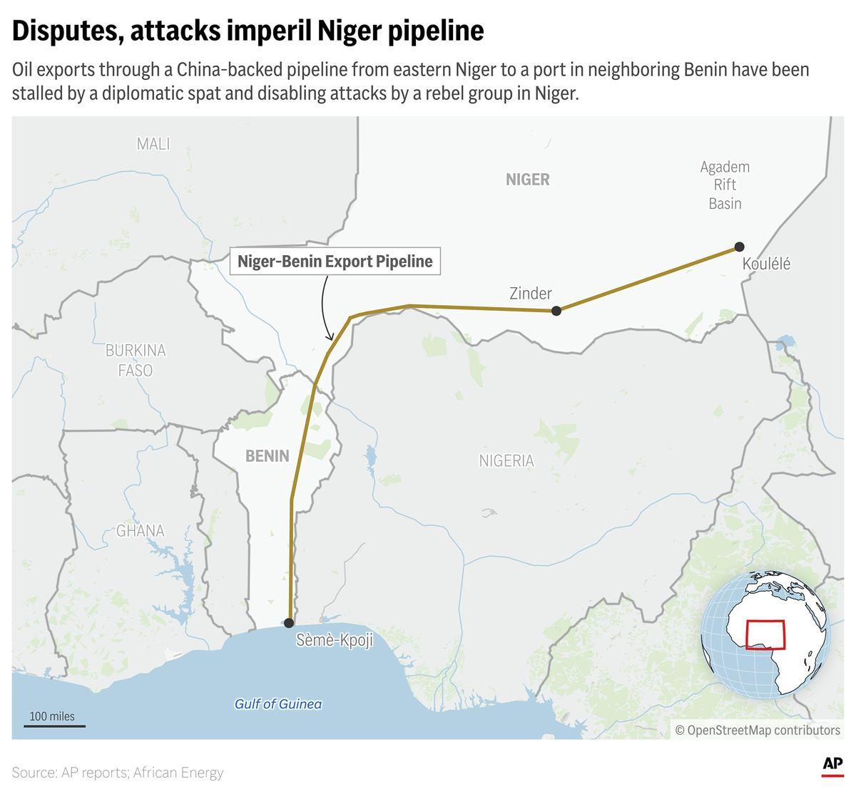
Prelims level: Niger, Niger Benin Export Pipeline
Why in the News?
The China-backed Niger-Benin Export Pipeline that would make Niger an oil-exporting country is being threatened by an internal security crisis and a diplomatic dispute with neighboring Benin.
These issues arose after last year’s coup that toppled Niger’s democratic government.
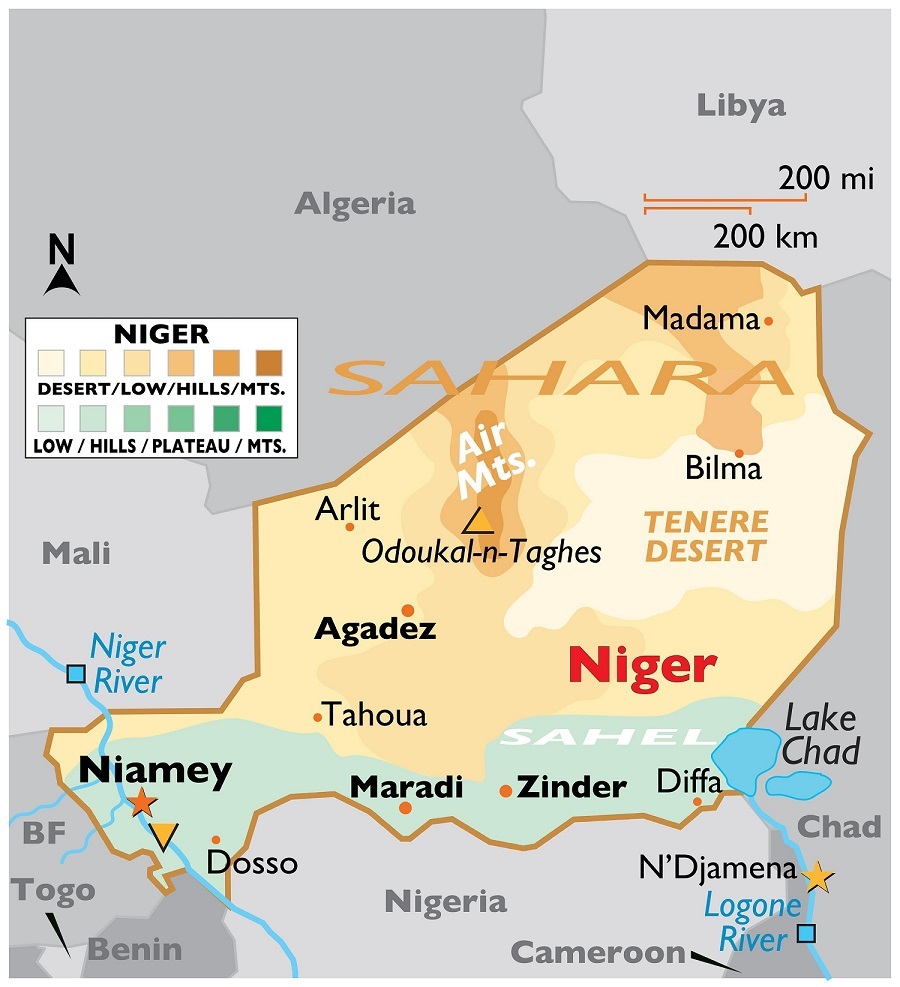
About Niger
Niger, located in West Africa, is a landlocked country known for its vast desert landscapes and significant cultural heritage.
The northern region of Niger is dominated by the Sahara Desert, comprising more than half of the country.
The central part of Niger is characterized by the Sahel, a semi-arid transition zone between the Sahara
The Aïr Mountains, located in the northern central part are a significant mountain range with the highest peak, Mont Idoukal-n-Taghès (2,022 m).
The Niger River is the country’s primary water source.
Lake Chad is a significant body of water shared with Nigeria, Chad, and Cameroon. Its size keep on fluctuating.
About Niger Benin Export Pipeline
The 1,930-kilometer pipeline runs from Niger’s Chinese-built Agadem oil field to the port of Cotonou in Benin.
It was designed to help Niger achieve an almost 5x increase in oil production through a $400 million deal with China’s state-run national petroleum company.
The pipeline faces significant challenges, including a recent diplomatic disagreement with Benin.
These issues threaten to strain Niger’s economy, heavily reliant on external support now withheld after a coup.
PYQ:
[2018] Which of the following has/have shrunk immensely/dried up in the recent past due to human activities?
Aral Sea
Black Sea
Lake Baikal
Select the correct answer using the code given below:
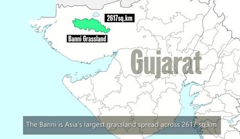
The Gandhi Sagar sanctuary in Madhya Pradesh is the preferred location for the next batch of cheetah’s relocation plan.
However, Banni in the Rann of Kutch, Gujarat is also being prepared to house some of them.
Cheetah Reintroduction in India:
In India, cheetahs disappeared in the early 1950s due to hunting and the loss of their habitat.
The ‘Action Plan for Reintroduction of Cheetah in India /Project Cheetah (2022)’ aims to bring cheetahs from African countries to various national parks.
It is spearheaded by the National Tiger Conservation Authority (NTCA).
Recently, cheetahs from Namibia were reintroduced in Kuno National Park, Madhya Pradesh.
Cheetah are listed as VULNERABLE by the IUCN; Schedule II of the Wild Life (Protection) Act, 1972.
Kuno NP and Gandhi Sagar has an ideal habitat parallel to Maasai Mara (a National Park) in Kenya, suitable for cheetahs.
About Gandhi Sagar Wildlife Sanctuary
It is located in western Madhya Pradesh and covers an area of 368.62 sq km.
It is a flat rocky plateau characterized by shallow topsoil and exposed sheetrock.
It is divided by the Chambal River, with the Gandhi Sagar dam and reservoir within its boundaries.
Flora and Fauna:
Flora: The sanctuary features a savannah ecosystem with open grasslands interspersed with dry deciduous trees. Riverine valleys within the sanctuary support evergreen vegetation.
Fauna: The sanctuary is home to a diverse range of wildlife, including species like leopards, sloth bears, striped hyenas, grey wolves, golden jackals, jungle cats, Indian foxes, and marsh crocodiles.
About Banni Grasslands:
The Banni Grassland is located in the Kutch district of Gujarat, covering around 3,847 square km.
The climate is arid and semi-arid, with extremely hot summers (temperatures above 45°C) and mild winters (12°C to 25°C), receiving 300-400 mm of annual rainfall mainly during the monsoon.
Flora: Grasses such as Dichanthium, Sporobolus, and Cenchrus species, with salt-tolerant plants, shrubs, and trees like Acacia and the invasive Prosopis juliflora.
Fauna: Indian wolf, hyena, chinkara, Great Indian Bustard, flamingos, and various raptors, reptiles, and invertebrates.
It is inhabited by pastoral communities like the Maldharis, who rely on livestock grazing (cattle, buffalo, and sheep) for their livelihood.
Agriculture is limited due to arid conditions, with some areas used for salt production.
PYQ:
[2024] Consider the following statements:
1. Lions do not have a particular breeding season.
2. Unlike most other big cats, cheetahs do not roar.
3. Unlike male lions, male leopards do not proclaim their territory by scent marking.
Which of the statements given above are correct?
(a) 1 and 2 only
(b) 2 and 3 only
(c) 1 and 3 only
(d) 1, 2 and 3
[2012] Consider the following: (2012)
Black-necked crane
Cheetah
Flying squirrel
Snow leopard
Which of the above are naturally found in India?
(a) 1, 2 and 3 only
(b) 1, 3 and 4 only
(c) 2 and 4 only
(d) 1, 2, 3 and 4
From UPSC perspective, the following things are important :
Prelims level: Gharial and its conservation, Kaziranga NP
Why in the News?
In Kaziranga National Park and Tiger Reserve, a lone female gharial has emerged as a significant presence, marking a potential revival for the species in the Brahmaputra River.
About Kaziranga National Park and Tiger Reserve:
Located in the state of Assam, Kaziranga is renowned for its biodiversity and conservation efforts.
Established in 1905 as a reserve forest and declared a national park in 1974.
Designated as a UNESCO World Heritage Site in 1985 for its unique natural environment and successful conservation of the Great One-Horned Rhinoceros.
Kaziranga is home to the highest density of tigers among protected areas in the world.
It hosts two-thirds of the world’s Great One-Horned Rhinoceros population, a significant conservation success story.
The park spans approximately 430 square kilometers (166 square miles) of grasslands, wetlands, and forests.
One-Horned Rhinoceros:
One–Horned Rhinos: IUCN Red List Status: Vulnerable; CITES: Appendix I ; WPA, 1972: Schedule I.
Mainly found in Assam, West Bengal.
Assam hosts about 2,640 rhinos across Pobitora WLS, Rajiv Gandhi Orang NP, Kaziranga NP, and Manas NP.
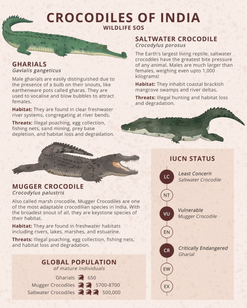
About Gharial
The Gharial is a fish-eating crocodile native to the Indian subcontinent.
They are a crucial indicator of clean river water.
It is also found in the rainforest biome of Mahanadi in Satkosia Gorge Sanctuary, Odisha.
Gharials are ‘Critically Endangered’in the IUCN Red List of Species.
The species is also listed under Schedule I of the Wild Life (Protection) Act, 1972.
National Chambal Sanctuary along the river Chambal in Madhya Pradesh is the biggest protected area of the species.
Recent findings of Gharial in Kaziranga
Gharials, distinguished by their long, narrow snouts, were believed to have disappeared from the Brahmaputra by the 1950s.
The female gharial, initially spotted in 2021, has grown to nearly adult size, providing hope for their reintroduction into the ecosystem.
From UPSC perspective, the following things are important :
Prelims level: Nicobar Triangle, GNI Project
Why in the News?
The opposition party has demanded the immediate suspension of all clearances granted to NITI Aayog’s Great Nicobar Island (GNI) Project.
It alleged violations of due process, legal and constitutional provisions protecting tribal communities.
Great Nicobar Island: An Overview
Geography and Ecology: Southernmost tip of India, part of the Andaman and Nicobar archipelago comprising 600-odd islands.
Environment: Hilly, covered with lush rainforests, annual rainfall of around 3,500 mm.
Biodiversity: Hosts numerous endangered and endemic species including the giant leatherback turtle, Nicobar megapode, Great Nicobar crake, Nicobar crab-eating macaque, and Nicobar tree shrew.
Area: 910 sq km with mangroves and Pandan forests along the coast.
Indigenous Communities:
Shompen Tribe: Approximately 250 people live in interior forests, predominantly hunter-gatherers, classified as a Particularly Vulnerable Tribal Group.
Nicobarese Community: Two groups – Great Nicobarese and Little Nicobarese, practice farming and fishing.
Resettlement: The Great Nicobarese were resettled in Campbell Bay after the 2004 tsunami.
Administrative Hub: Campbell Bay serves as the administrative hub, housing local offices of the Andaman and Nicobar administration and the panchayat.
Back2Basics:“Nicobar Triangle”
It is named after the Nicobar Islands, which are located at the northern apex of this triangular area.
The islands within the Nicobar Triangle include:
Nicobar Islands: This group of islands belongs to India and is situated to the south of the Andaman Islands. They are known for their diverse flora and fauna and are inhabited by indigenous tribes.
Andaman Islands: Located to the north of the Nicobar Islands, the Andaman Islands are also part of India. They are well-known for their lush forests, coral reefs, and indigenous tribes.
Indonesian Archipelago: To the south and southeast of the Nicobar Islands lies the Indonesian archipelago, which includes thousands of islands spanning a vast area between the Indian and Pacific Oceans.
What is GNI Project?
The GNI Project refers to the “Holistic Development of Great Nicobar Island,” a proposed mega project being piloted by NITI Aayog.
Implementing Agency: The project is to be implemented by the Andaman and Nicobar Islands Integrated Development Corporation (ANIIDCO).
Historical Context: Development plans for a port in Great Nicobar date back to the 1970s, aimed at leveraging its strategic location near the Malacca Strait.
The project aims to develop the southern end of the Andaman and Nicobar group of Islands in the Bay of Bengal by constructing –
Transshipment port
Dual-use military-civil international airport
Power plant (450 MVA gas and solar-based) and
A township over a span of 30 years on more than 160 sq. km of land, of which 130 sq. km is primary forest
Features of the Project
Transshipment hub of the East: The proposed port will allow Great Nicobar to participate in the regional and global maritime economy by becoming a major player in cargo transshipment.
Naval control: The port will be controlled by the Indian Navy, while the airport will have dual military-civilian functions and will cater to tourism as well.
Urban amenities: Roads, public transport, water supply and waste management facilities, and several hotels have been planned to cater to tourists.
Significance of the project
Economic significance: The proposed port would allow GNI to become a significant player in cargo transhipment, as it is positioned equidistant from Colombo, Port Klang (Malaysia), and Singapore.
Strategic significance: The proposal to develop GNI has been on the table since the 1970s, and it has been highlighted repeatedly as a crucial element for national security and consolidation of the Indian Ocean Region.
In recent years, the escalating Chinese presence in the Indian Ocean has added greater urgency to this imperative.
Issues with the Project
The project entails the deforestation of 130 sq km, and felling 10 lakh trees, threatens biodiversity at Galathea Bay, displaces indigenous tribes, lacks thorough impact assessments, and poses seismic risks to vulnerable communities.
Due-process Violations highlighted by the ‘Opposition’
(1) Did not recognise the grant ownership: The island administration did not recognise or grant ownership of any forest land to local tribespeople as per FRA, a requisite step under the Forest Conservation Rules, 2017, before Stage-I clearance is granted.
This is despite the fact that Rule 6(3)(e) of Forest Conservation Rules-2017 (FCR) requires that any diversion of forest land first requires the District Collector to recognise and vest rights to locals under the FRA.
The legislation allows forest communities the right to control and manage the use of the forest land over which they hold titles, and their consent is mandatory for diverting it.
(2) Inconsistencies with Stage-I Clearance: The Stage-I clearance for the project was granted in October 2022, two years after the application was received. Monthly progress reports show that the district administration did not process any claims over forest land under the FRA in the 26 months since project sanction.
(3) Withdrawal of Consent: Weeks after the Stage-I clearance was granted, the Tribal Council at Campbell Bay withdrew the consent granted by the Gram Sabha.
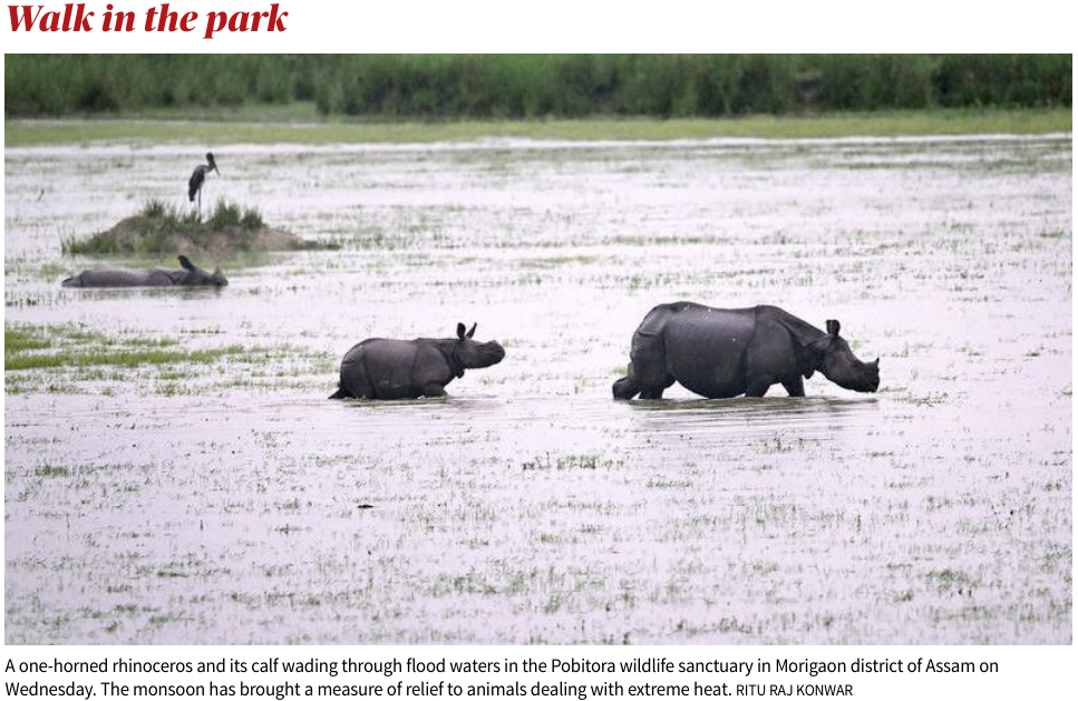
The monsoon has brought a measure of relief to animals especially the one-horned rhinoceros in Pobitora Wildlife Sanctuary dealing with extreme heat.
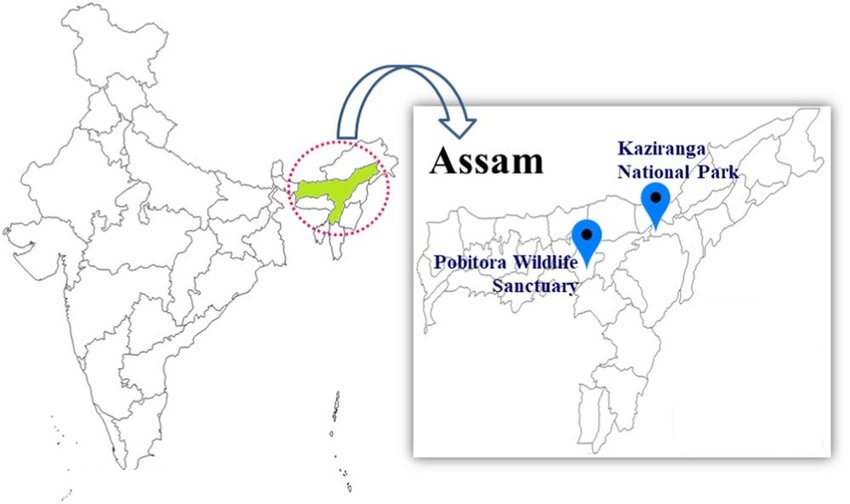
About Pobitora Wildlife Sanctuary
Pobitora Wildlife Sanctuary boasts the highest density of one-horned rhinos globally, second only to Kaziranga National Park in Assam.
Often dubbed as ‘Mini Kaziranga,’ Pobitora shares a similar landscape and vegetation to its renowned counterpart.
The sanctuary shelters variousendangered species, including one-horned rhinoceros, leopards, leopard cats, fishing cats, jungle cats, feral buffaloes, wild pigs, and Chinese pangolins.
Approximately 72% of Pobitora’s area comprises a wet savannah dominated by Arundo donax and Saccharum grasses, while the rest is covered by water bodies.
About One-Horned Rhino:
IUCN Red List Status: Vulnerable.
Habitat– Rhinos are mainly found in Assam, West Bengal and Uttar Pradesh.
Assam has an estimated 2,640 rhinos in four protected areas, i.e. Pobitora Wildlife Reserve, Rajiv Gandhi Orang National Park, Kaziranga National Park, and Manas National Park.
Note: About 2,400 of them are in the Kaziranga National Park and Tiger Reserve (KNPTR).
PYQ:
[2019] Consider the following statements:
The Asian lion is naturally found in India only
Double-humped camel is naturally found in India only
One-horned rhinoceros is naturally found in India only
Which of the statements given above is/are correct?
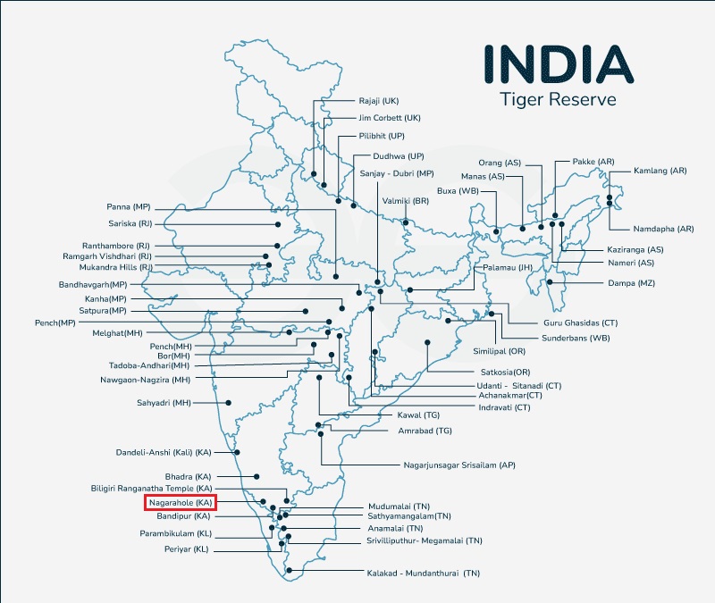
Ashwatthama, a 38-year-old elephant, died of electrocution near Karnataka’s Nagarahole Tiger Reserve.
The High Court of Karnataka suo motu initiated a PIL petition to inquire about this incident attributed to a lack of care and diligence by concerned authorities.
Nagarahole Tiger Reserve
Located in the Western Ghats in Karnataka; Spans over 643 square kilometers.
Declared a wildlife sanctuary in 1955 and a tiger reserve in 1999.
Part of the Nilgiri Biosphere Reserve is recognised as an Important Bird Area (IBA) and a Project Tiger, Project Elephant reserve.
Managed by the Karnataka Forest Department with efforts focused on conservation, ecotourism, and community engagement.
The reserve is crisscrossed by several rivers such as the Kabini River, Lakshmana Tirtha River, and Moyar River.
Flora and Fauna: Known for its diverse ecosystem, including tropical and moist deciduous forests, home to a variety of wildlife such as tigers, leopards, elephants, gaur, and several species of deer and birds.
Protective Measures:Project Elephant
It was launched in the year 1992 as a Centrally Sponsored Scheme with the following objectives:
To protect elephants, their habitat & corridors
To address issues of man-animal conflict
The welfare of captive elephants
It covers 23 states across India.
The Ministry of Environment, Forest and Climate Change provides financial and technical support to major elephant range states in the country through the project.
It contributed to the increase in the wild elephant population from around 25,000 in 1992 to about 30,000 in 2021.
Status of Elephant Conservation in India
Details
Population Estimate
India hosts the largest population of wild Asian Elephants (Elephas maximus), with around 29,964 individuals,
Approximately 60% of the global population (2017 census).
Leading States
Karnataka holds the highest number of elephants, followed by Assam and Kerala.
Conservation Status
IUCN Red List: Endangered.
CMS: Appendix I.
Wildlife (Protection) Act, 1972: Listed under Schedule I,
CITES: Appendix I.
PYQ:
[2020] With reference to Indian elephants, consider the following statements:
The leader of an elephant group is a female.
The maximum gestation period can be 22 months.
An elephant can normally go on calving till the age of 40 years only.
Among the States in India, the highest elephant population is in Kerala.
Which of the statements given above is/are correct?
From UPSC perspective, the following things are important :
Prelims level: Delos Monuments, World Heritage Sites, Various WHS in India
Why in the News?
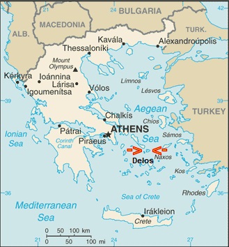
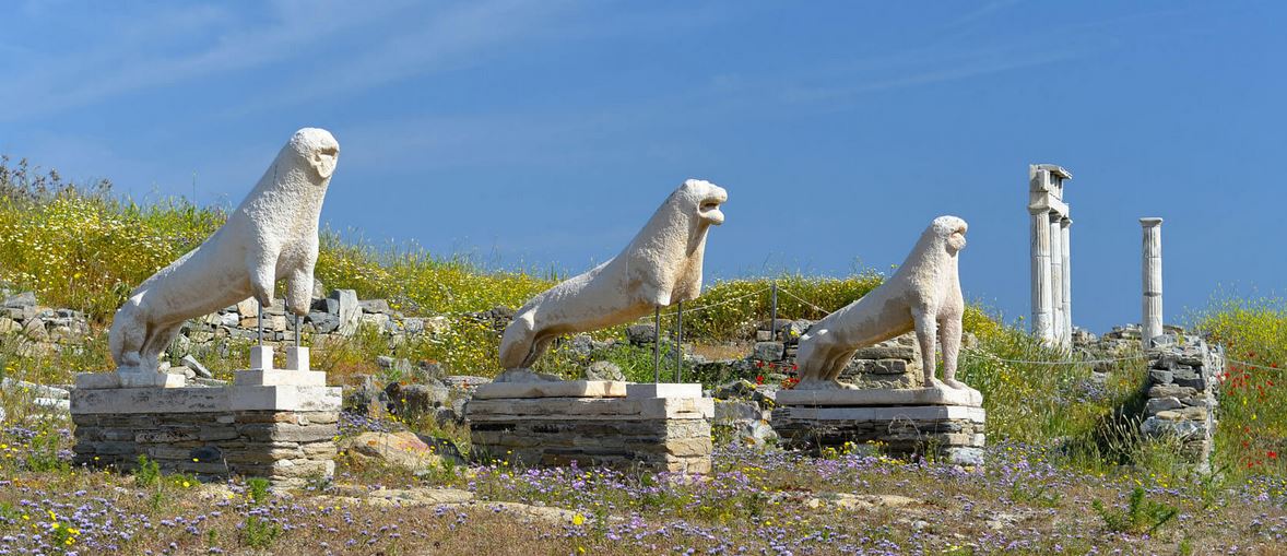
Delos, a UNESCO World Heritage site situated close to Mykonos, Greece, played a pivotal role as a sanctuary in the ancient Greek and Roman civilizations.
Scientists warn that Delos faces imminent destruction within the next 50 years due to rising sea levels caused by climate change.
About Delos
Delos is a small island located in the Aegean Sea, part of the Cyclades archipelago in Greece.
It is considered as the birthplace of Apollo, the god of light, arts, and healing, and his sister Artemis, the goddess of the hunt.
Its ancient ruins date back to the 3rd millennium BCE.
These ruins include temples, houses, sanctuaries, theatres, and other public buildings.
It served as a port and trading hub, connecting the civilizations of the eastern Mediterranean with those of the west.
Delos was declared as a UNESCO World Heritage Site in 1990.
Ruins and Monuments:
Some of the most notable ruins and monuments on Delos include the Terrace of the Lions, the Temple of Apollo, the House of the Dolphins, the Theater District, and the Sacred Lake.
About UNESCO World Heritage Sites (WHS)
Details
Definition
A WHS is a landmark or area with legal protection by an international convention administered by UNESCO.
Criteria
WHS are designated for their cultural, historical, scientific, or other forms of significance.
World Heritage Convention
1972 Convention Concerning the Protection of the World Cultural and Natural Heritage established the framework for preserving the world’s outstanding heritage.
191 State Parties, including India, have ratified the World Heritage Convention.
Number of Sites
There are currently 1,172 World Heritage Sites across 166 countries.
Types of Sites
913 cultural sites
220 natural sites
39 mixed properties
World Heritage Committee
Evaluate nominated sites and inscribe them on the World Heritage List.
Preservation
Member states commit to protecting their World Heritage Sites.
World Heritage Fund
The fund, supported by member contributions, provides assistance for preserving sites.
Selection Criteria
Sites must demonstrate Outstanding Universal Value (OUV) by meeting criteria defined in the Convention.
Advisory Bodies
International Council on Monuments and Sites (ICOMOS) and the International Union for Conservation of Nature (IUCN) assess nominated sites.
Criteria for Cultural Sites
Six criteria for significance related to human creative genius, cultural interchange, unique testimony, outstanding examples of architecture, tradition, and events.
Criteria for Natural Sites
Four criteria for significance related to natural phenomena, Earth’s evolutionary history, ecological processes, and biological diversity.
Legal Status
Once inscribed, each site remains the property of the state it belongs to, with shared responsibility for its preservation and protection.
Obligations
Member states are obligated to integrate heritage protection into regional planning, report on-site conditions, and preserve sites for future generations.
Enforcement
The Committee may provide assistance, deploy experts, or delist sites in extreme cases of endangerment.
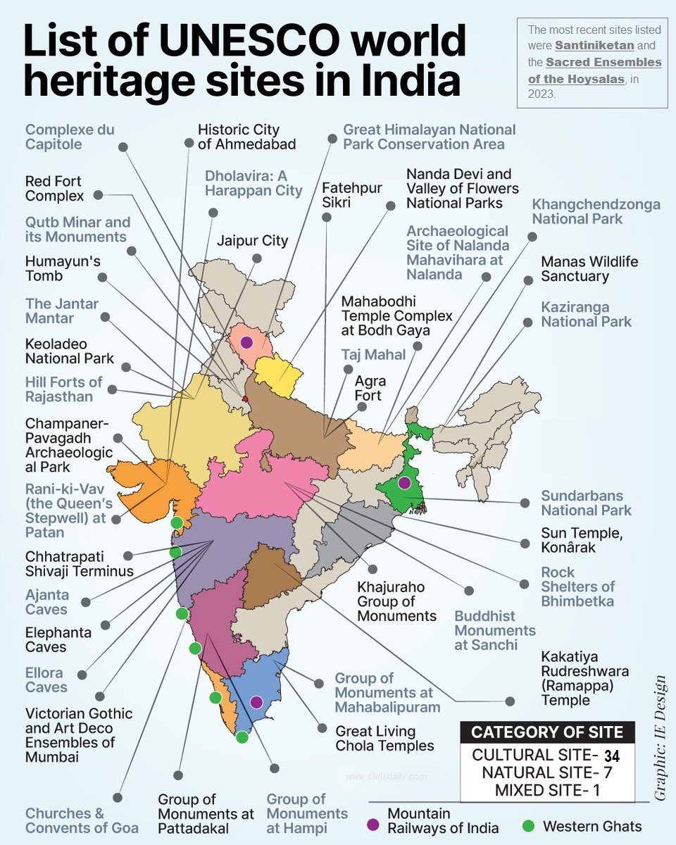
Important Sites in India:
There are 42 World Heritage Sites in India.
Out of these, 34 are cultural, 7 are natural, and 1, Khangchendzonga National Park, is of mixed type.
India has the sixth-most sites worldwide.
The first sites to be listed were the Ajanta Caves, Ellora Caves, Agra Fort, and Taj Mahal, all of which were inscribed in the 1983 session of the World Heritage Committee.
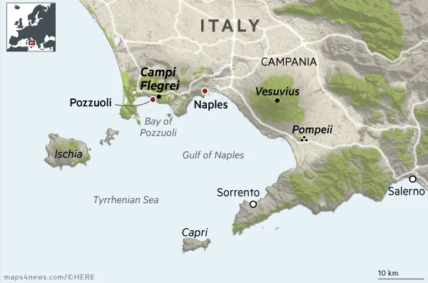
From UPSC perspective, the following things are important :
Prelims level: Campi Flegrei Super Volcano, Mt. Vesuvius, Volcanic eruptions in news.
Why in the News?
A 4.4 magnitude earthquake struck Italy’s Campi Flegrei super volcano, with Pozzuoli as the epicentre. Felt as far as Naples, it’s the strongest tremor in 40 years
Bradyseism Concerns near Campi Flegrei:
Campi Flegrei is prone to bradyseism, where ground elevation changes due to subsurface pressure.
The area, located 50 kilometres from Mt. Vesuvius, is undergoing a new cycle of bradyseism, according to volcanologists.
Over 500,000 people reside in the red zone adjacent to Campi Flegrei, prompting the Italian Civil Protection Agency to update evacuation plans.
AboutCampi Flegrei Volcano
Campi Flegrei, also known as the Phlegraean Fields, is a large volcanic area located in the western suburbs of Naples, Italy.
It is one of the most active volcanic systems in the world and has been active for at least 50,000 years.
Its Volcanic System:
Location: Campi Flegrei is situated within the Campanian volcanic arc in southern Italy, extending from the city of Naples to the Gulf of Pozzuoli.
Geological Formation: The volcanic system of Campi Flegrei is characterized by a large caldera, which is a collapsed volcanic crater, surrounded by numerous volcanic vents, craters, and lava domes. The caldera has a diameter of about 13 kilometers (8 miles).
Volcanic Activity: Campi Flegrei is considered a supervolcano due to its size and potential for large eruptions. It has experienced numerous periods of volcanic activity throughout its history, including explosive eruptions, lava flows, and phreatic (steam-driven) eruptions.
Terrain Features: The landscape of Campi Flegrei is characterized by volcanic features such as craters, fumaroles (steam vents), mud pots, and hot springs.
PYQ:
[2021] Mention the global occurrence of volcanic eruptions in ‘2021’ and their impact on regional environment.
[2018] Consider the following statements:
The Barren Island volcano is an active volcano located in the Indian Territory.
Barren Island lies about 140 km east of Great Nicobar.
The last time the Barren Island volcano erupted was in 1991 and it has remained inactive since then.
Which of the statements given above is/are correct?
From UPSC perspective, the following things are important :
Prelims level: Chabahar Port, Persian Gulf Mapping
Mains level: NA
Why in the news?
India and Iran signed a 10-year agreement for the operation of the Chabahar port, marking a significant milestone in their cooperation.
Back2Basics: Chabahar Port
The port is located in southeastern Iran in the Sistan-Baluchistan province, on the Gulf of Oman and at the mouth of the Strait of Hormuz.
It is called the “Golden Gate” to Central Asian land-locked countries of Afghanistan, Turkmenistan and Uzbekistan.
It serves as Iran’s only oceanic port and consists of two separate ports named Shahid Kalantari and Shahid Beheshti.
It is only about 170 km west of the Gwadar port if Pakistan.
The development of Chabahar port was initiated by India with a MoU in 2015 and executed in 2016 during PM Narendra Modi’s visit to Iran.
About the Agreement
The contract, signed between Indian Ports Global Ltd. (IPGL) and Port and Maritime Organisation (PMO) of Iran, involves substantial investment and development initiatives.
IPGL will invest approximately $120 million in equipping the Shahid-Behesti terminal, enhancing the port’s efficiency and capacity.
India has extended a credit window of $250 million for mutually identified projects aimed at improving Chabahar-related infrastructure, emphasizing its commitment to regional development.
Strategic Importance of Chabahar Port to India
Chabahar port will boost India’s access to Iran, the key gateway to the International North-South Transport Corridor that has sea, rail and road routes between India, Russia, Iran, Europe and Central Asia.
Chabahar port will be beneficial to India in countering Chinese presence in the Arabian Sea which China is trying to ensure by helping Pakistan develop the Gwadar port.
India can bypass Pakistan in transporting goods to Afghanistan.
Economic Significance
Chabahar Port is at an important point on the Arabian Sea, with easy access from India’s west coast.
Kandla port in Gujarat is the closest port at 550 nautical miles, while the distance between Chabahar and Mumbai is 786 nautical miles.
Since 2019, the port has handled more than 80,000 twenty-foot equivalent units (TEUs) of container traffic and more than 8 million tonnes of bulk and general cargo.
The port also offers an alternative route from the Strait of Hormuz for cargo traffic between Central Asian countries and Afghanistan.
PYQ:
[2017] What is the importance of developing Chabahar Port by India?
(a) India’s trade with African countries will enormously increase.
(b) India’s relations with oil-producing Arab countries will be strengthened.
(c) India will not depend on Pakistan to access Afghanistan and Central Asia.
(d) Pakistan will facilitate and protect the gas pipeline installation between Iraq and India.
Maharashtra’s plan to increase tigers count in Sahyadri-Konkan Wildlife Corridor by translocating tigers from Tadoba-Andhari Tiger Reserve (TATR) (Chandrapur, Maharashtra) underscores the critical role of wildlife corridors in conservation efforts.
About Tadoba-Andhari Tiger Reserve (TATR)
Tadoba became one of India’s earliest national parks when it was declared in 1955, alongside Kanha National Park.
The name “Tadoba” is derived from the deity “Tadoba” or “Taru,” worshipped by local Gond Tribals, and “Andhari” refers to the Andhari River flowing through the reserve.
It was later expanded and officially merged with the Andhari Wildlife Sanctuary in 1993 to form the TATR.
TATR is regarded as one of the world’s most preferred destinations for tiger sightings and is a critical part of Project Tiger, aimed at conserving tigers in India.
The reserve has 115 tigers, including 88 within the forest and 27 in the areas immediately surrounding the reserve.
About Sahyadri-Konkan Wildlife Corridor
The Sahyadri-Konkan corridor(Sahyadri-Radhanagari-Goa-Karnataka), plays a vital role in conserving wildlife, particularly tigers, in the northern Western Ghats region.
It spans throughout the states of Maharashtra, Goa, and Karnataka, specifically through the Western Ghats, one of the world’s eight biodiversity hotspots.
Protected Areas Connected:
Sahyadri Tiger Reserve (includes Koyna Wildlife Sanctuary (WLS) and Chandoli National Park) and Radhanagari Wildlife Sanctuary (Maharashtra);
Bhimgad Wildlife Sanctuary and Kali Tiger Reserve(includes Anshi National Park and Dandeli WLS) in (Karnataka);
Mollem National Park, Netravali Wildlife Sanctuary (Goa).
Fauna: Tiger (Panthera tigris), Indian leopard (Panthera pardus), dhole (Cuon alpinus), and sloth bear (Melursus ursinus), etc.
The Western Ghats, including parts of the corridor, are designated as a UNESCO World Heritage Site in 2012 due to their outstanding universal value in terms of biodiversity and endemic species.
PYQ:
[2020] Among the following Tiger Reserves, which one has the largest area under “Critical Tiger Habitat”?
From UPSC perspective, the following things are important :
Prelims level: Garo Hills
Mains level: NA
Why in the news?
Geological Survey of India (GSI) explorers have made a breakthrough, uncovering ancient fossils in Tolegre, South Garo Hills of Meghalaya.
It is speculated that the fossils could be linked to the genera Rhodocetus or Amulocetus (now extinct), considered ancestors of modern whales.
About Garo Hills
The Garo Hills, located in Meghalaya, are part of the Garo-Khasi range, one of the hill ranges in the northeastern region of India.
They are situated in the western part of Meghalaya, bordering Bangladesh to the south and west.
The terrain of the Garo Hills is rugged and hilly, characterized by dense forests, steep slopes, and deep valleys.
The Nokrek is highest Peak, which stands at approximately 1,415 meters (4,642 feet) above sea level.
The climate in the Garo Hills is typically humid subtropical, with heavy rainfall during the monsoon season, which usually lasts from June to September.
Numerous rivers and streams, including the Brahmaputra, Someshwari, and Jinjiram rivers crisscross this region.
The region is also known for its picturesque waterfalls, such as the Pelga Falls, located near Tura, the largest town in the Garo Hills.
The Nokrek National Park, located within, is recognized as a UNESCO Biosphere Reserve and is home to various endangered species, including the Asian elephant and the red panda.
The Garo Hills are inhabited predominantly by the Garo tribe, one of the major ethnic groups in Meghalaya.
PYQ:
[2013] Consider the following pairs:
1. Nokrek Bio-Sphere Reserve : Garo Hills
2. Logtak (Loktak) Lake : Barail Range
3. Namdapha National Park: Daphla Hills
Which of the above pairs is/are correctly matched?