Note4Students
From UPSC perspective, the following things are important :
Prelims level: Zoji La Pass and other himalayan passes
Mains level: Critical border infrastructures

Union Minister for Road Transport and Highways has inspected the work on Zojila and Z Morh tunnels.
Zojila Tunnel
- The Zojila is set to be Asia’s longest bi-directional tunnel.
- It will connect Srinagar, Dras, Kargil and Leh via a tunnel through the famous Zojila Pass.
- Located at more than 11,500 feet above sea level, the all-weather Zojila tunnel will be 14.15 km long and ensure road connectivity even during winters.
- It will make the travel on the 434-km Srinagar-Kargil-Leh Section of NH-1 free from avalanches, enhance safety and reduce the travel time from more than 3 hours to just 15 minutes.
- The speed limit inside the tunnel is likely to be the same as in the Atal tunnel – 80 kmph.
Z-Morh tunnel
- The Z-Morh tunnel — being developed at Sonmarg — will provide it all-weather connectivity with Srinagar allowing it to remain open to tourists all year round.
- It is likely to be ready by December 2023 and is being developed at a cost of ₹2,378 crore.
Significance of these tunnels
- The project holds strategic significance as Zojila Pass is situated at an altitude of 11,578 feet on the Srinagar-Kargil-Leh National Highway and remains closed during winters due to heavy snowfall.
- At present, it is one of the most dangerous stretches in the world to drive a vehicle and this project is also geo-strategically sensitive.
UPSC 2022 countdown has begun! Get your personal guidance plan now! (Click here)
Back2Basics: Major Passes in India

Get an IAS/IPS ranker as your 1: 1 personal mentor for UPSC 2024
Attend Now
Note4Students
From UPSC perspective, the following things are important :
Prelims level: MMD Biosphere Reserve, BRs in India
Mains level: Not Much

UNESCO has designated Mura-Drava-Danube (MDD) as the world’s first ‘five-country biosphere reserve’.
About Mura-Drava-Danube BR
- The biosphere reserve covers 700 kilometres of the Mura, Drava and Danube rivers and stretches across Austria, Slovenia, Croatia, Hungary and Serbia.
- The total area of the reserve — a million hectares — in the so-called ‘Amazon of Europe’, makes it the largest riverine protected area on the continent.
- The reserve is home to floodplain forests, gravel and sand banks, river islands, oxbows and meadows.
- It is home to continental Europe’s highest density of breeding white-tailed eagle (more than 150 pairs), as well as endangered species such as the little tern, black stork, otters, beavers and sturgeons.
- It is also an important annual resting and feeding place for more than 250,000 migratory birds, according to WWF.
- Almost 900,000 people live in the biosphere reserve. (UPSC may ask if it is uninhabited.)
Significance of this BR
- The new reserve represented an important contribution to the European Green Deal and contributes to the implementation of the EU Biodiversity Strategy in the Mura-Drava-Danube region.
- The strategy’s aim is to revitalize 25,000 km of rivers and protect 30 per cent of the European Union’s land area by 2030.
- The declaration as BR puts river revitalization, sustainable business practices enhancing cross-border cooperation into focus.
Ignore at your own risk! Its better to correct it here itself.
Such PYQs are ought to repeat any number of times in UPSC CSE.
Q. Consider the following statements:
- The boundaries of a National Park are defined by legislation.
- A Biosphere Reserve is declared to conserve a few specific species of flora and fauna.
- In a Wildlife Sanctuary, limited biotic interference is permitted.
Which of the above statements is/are correct?
(a) 1 only
(b) 2 and 3 only
(c) 1 and 3 only
(d) 1, 2 and 3
Post your answers here.
Back2Basics: UNESCO Biosphere Reserves
- Biosphere reserves are ‘learning places for sustainable development’.
- They are nominated by national governments and remain under the sovereign jurisdiction of the states where they are located.
- They are designated under the intergovernmental MAB Programme by the Director-General of UNESCO following the decisions of the MAB International Coordinating Council (MAB ICC).
- Their status is internationally recognized. Member States can submit sites through the designation process.
- Biosphere reserves include terrestrial, marine and coastal ecosystems.
They integrate three main “functions”:

- Conservation of biodiversity and cultural diversity
- Economic development that is socio-culturally and environmentally sustainable
- Logistic support, underpinning development through research, monitoring, education and training
(a) Core Areas
It comprises a strictly protected zone that contributes to the conservation of landscapes, ecosystems, species and genetic variation
(b) Buffer Zones
It surrounds or adjoins the core area(s), and is used for activities compatible with sound ecological practices that can reinforce scientific research, monitoring, training and education.
(c) Transition Area
The transition area is where communities foster socio-culturally and ecologically sustainable economic and human activities.
UNESCO recognized BRs in India
Year of
recognition
|
Name
|
States
|
| 2000 |
Nilgiri Biosphere Reserve |
Tamil Nadu |
| 2001 |
Gulf of Mannar Biosphere Reserve |
Tamil Nadu |
| 2001 |
Sundarbans Biosphere Reserve |
West Bengal |
| 2004 |
Nanda Devi Biosphere Reserve |
Uttarakhand |
| 2009 |
Pachmarhi Biosphere Reserve |
Madhya Pradesh |
| 2009 |
Nokrek Biosphere Reserve |
Meghalaya |
| 2009 |
Simlipal Biosphere Reserve |
Odisha |
| 2012 |
Achanakmar-Amarkantak Biosphere Reserve |
Chhattisgarh |
| 2013 |
Great Nicobar Biosphere Reserve |
Great Nicobar |
| 2016 |
Agasthyamala Biosphere Reserve |
Kerala and Tamil Nadu |
| 2018 |
Kanchenjunga Biosphere Reserve |
Part of North and West Sikkim districts |
| 2020 |
Panna Biosphere Reserve |
Madhya Pradesh |
|
|
|
|
UPSC 2022 countdown has begun! Get your personal guidance plan now! (Click here)
Get an IAS/IPS ranker as your 1: 1 personal mentor for UPSC 2024
Attend Now
Note4Students
From UPSC perspective, the following things are important :
Prelims level: Pilibhit Tiger Reserve
Mains level: Not Much
A herd of around 25 elephants from Nepal’s Shuklaphanta National Park reached the tiger reserve in Uttar Pradesh almost a month back.
Pilibhit Tiger Reserve
- Pilibhit Tiger Reserve is located in Pilibhit district of Uttar Pradesh and was notified as a tiger reserve in 2014.
- It is one of the few well-forested districts in Uttar Pradesh.
- It forms part of the Terai Arc Landscape in the upper Gangetic Plain along the India-Nepal border.
- The habitat is characterized by sal forests, tall grasslands and swamp maintained by periodic flooding from rivers.
- The Sharda Sagar Dam extending up to a length of 22 km is on the boundary of the reserve.
- The tiger reserve got the first international award TX2 for doubling the tiger population in a stipulated time.
Try answering this PYQ:
Q.Consider the following protected areas:
- Bandipur
- Bhitarkanika
- Manas
- Sunderbans
Which of the above are declared Tiger Reserves?
(a) 1 and 2 only
(b) 1, 3 and 4 only
(c) 2, 3 and 4 only
(d) 1, 2, 3 and 4
Post your answers here.
UPSC 2022 countdown has begun! Get your personal guidance plan now! (Click here)
Get an IAS/IPS ranker as your 1: 1 personal mentor for UPSC 2024
Attend Now
Note4Students
From UPSC perspective, the following things are important :
Prelims level: Thamirabarani Civilization
Mains level: Ancient Indian Civilizations

A carbon dating analysis of rice with soil, found in a burial urn at Sivakalai in Thoothukudi district of Tamil Nadu has yielded the date of 1155 BC, indicating that the Thamirabarani civilization dates back to 3,200 years.
About Thamirabarani River

- The Thamirabarani or Tamraparni or Porunai is a perennial river that originates from the Agastyarkoodam peak of the Pothigai hills of the Western Ghats.
- It flows through the Tirunelveli and Thoothukudi districts of the Tamil Nadu state of southern India into the Gulf of Mannar.
- It was called the Tamraparni River in the pre-classical period, a name it lent to the island of Sri Lanka.
- The old Tamil name of the river is Porunai.
Its history
- Its many name derivations of Tan Porunai include Tampraparani, Tamirabarni, Tamiravaruni.
- Tan Porunai nathi finds mention by classical Tamil poets in ancient Sangam Tamil literature Purananuru.
- Recognised as a holy river in Sanskrit literature Puranas, Mahabharata and Ramayana, the river was famed in the Early Pandyan Kingdom for its pearl and conch fisheries and trade.
- The movement of people, including the faithful, trade merchants and toddy tapers from Tamraparni river to northwestern Sri Lanka led to the shared appellation of the name for the closely connected region.
- One important historical document on the river is the treatise Tamraparni Mahatmyam.
- It has many ancient temples along its banks. A hamlet known as Appankoil is located on the northern side of the river.
Significance of the carbon dating
- This has provided evidence that there was a city civilisation in south India as long back as 3,200 years ago, the later part of the Indus Valley Civilisation.
- Vicinity to the ancient port of Muziris, now known as Pattanam, in Kerala add another significance to the trade history of this site.
- Now, research would be conducted at Quseir al-Qadim and Pernica Anekke in Egypt, which were once part of the Roman empire, as well as in Khor Rori in Oman, to establish the Tamils’ trade relations with these countries.
- Potsherds bearing Tamil scripts have been found in these countries.
- Studies would also be conducted in Southeast Asian countries, such as Indonesia, Thailand, Malaysia and Vietnam, where King Rajendra Chola had established supremacy.
UPSC 2022 countdown has begun! Get your personal guidance plan now! (Click here)
Also read
Sangam era older than previously thought, finds study
Get an IAS/IPS ranker as your 1: 1 personal mentor for UPSC 2024
Attend Now
Note4Students
From UPSC perspective, the following things are important :
Prelims level: Qeqertaq Avannarleq
Mains level: Impact of climate change

A group of researchers who went out to collect samples off the coast of Greenland in July found themselves on a tiny, uninhabited and previously unknown island.
Qeqertaq Avannarleq
- Measuring 60×30 metres and with a peak of three metres above sea level, it has now become the new northernmost piece of land on Earth.
- Before this, Oodaaq was marked as the Earth’s northernmost terrain.
- The new island is made up of seabed mud and moraine, i.e. soil, rock and other material left behind by moving glaciers, and has no vegetation.
- The group has suggested the discovery be named ‘Qeqertaq Avannarleq’, which is Greenlandic for “the northernmost island”.
How this island came to existence?
Ans. Undoubtedly, climate change in Greenland
- Global warming has had a severe effect on the ice sheet of Greenland.
- The new island, which was exposed by shifting pack ice, is, however, not a direct consequence of climate change.
UPSC 2022 countdown has begun! Get your personal guidance plan now! (Click here)
Get an IAS/IPS ranker as your 1: 1 personal mentor for UPSC 2024
Attend Now
Note4Students
From UPSC perspective, the following things are important :
Prelims level: Pantanal Wetlands
Mains level: Not Much

Pantanal, the world’s largest tropical wetlands is facing a severe crisis due to wildfires and climate change.
Pantanal Wetlands
- The Pantanal is a natural region encompassing the world’s largest tropical wetland area, and the world’s largest flooded grasslands.
- It is located mostly within the Brazilian and extends to some portions of Bolivia and Paraguay.
- It sprawls over an area estimated at between 140,000 and 195,000 square kilometer.
- Roughly 80% of the Pantanal floodplains are submerged during the rainy seasons, nurturing a biologically diverse collection of aquatic plants and helping to support a dense array of animal species.
Risks faced
- Unlike the Amazon rainforest, vegetation in the Pantanal has evolved to coexist with fire — many plant species there require the heat from fires to germinate.
- Often caused by lightning strikes, those natural fires spring up at the end of the dry season, but the surrounding floodplains prevent them from spreading.
- What’s different now is the drought, contributing further to the unusually dry conditions and exacerbating the fire risk.
UPSC 2022 countdown has begun! Get your personal guidance plan now! (Click here)
Get an IAS/IPS ranker as your 1: 1 personal mentor for UPSC 2024
Attend Now
Note4Students
From UPSC perspective, the following things are important :
Prelims level: Deeper Beel
Mains level: Wetland conservation

The Ministry of Environment, Forest and Climate Change has notified the eco-sensitive zone of the Deepar Beel Wildlife Sanctuary on the south-western edge of Guwahati.
Deepar Beel
- Deepar Beel is one of the largest freshwater lakes in Assam and the State’s only Ramsar site besides being an Important Bird Area.
- It is located to the south-west of Guwahati city, in Kamrup Metropolitan district.
- It is a permanent freshwater lake, in a former channel of the Brahmaputra River, to the south of the main river.
- It is also called a wetland under the Ramsar Convention which has listed the lake in November 2002, as a Ramsar Site for undertaking conservation measures on the basis of its biological and environmental importance.
Major threats
- Deepar Beel has long been used as a sponge for Guwahati’s sewage via a couple of streams.
- The wetland has also suffered from seepage of toxins from a garbage dump at Boragaon adjoining it.
- It has for decades been threatened by a railway track — set to be doubled and electrified — on its southern rim, a garbage dump, and encroachment from human habitation and commercial units.
- The water has become toxic and it has lost many of its aquatic plants that elephants would feed on.
UPSC 2022 countdown has begun! Get your personal guidance plan now! (Click here)
Get an IAS/IPS ranker as your 1: 1 personal mentor for UPSC 2024
Attend Now
Note4Students
From UPSC perspective, the following things are important :
Prelims level: Sambhar Lake
Mains level: Not Much

The world-famous Sambhar Salt Lake in Rajasthan is constantly shrinking with the degradation of soil and water quality and a decline in the population of migratory birds.
Sambhar Lake
- The lake, situated 80 km south-west of Jaipur, is the country’s largest inland saline water body which attracts thousands of migratory birds every year.
- The death of more than 20,000 birds belonging to about 10 species which migrate annually to the lake had made international headlines in 2019.
- The lake receives water from six rivers: Mantha, Rupangarh, Khari, Khandela, Medtha and Samod.
- Sambhar has been designated as a Ramsar site because the wetland is a key wintering area for tens of thousands of pink flamingos and other birds that migrate from northern Asia and Siberia.
Threats: Illegal mining
- 30% of the Sambhar Lake’s area had been lost to mining and other activities, including the illegal salt pan encroachments.
- It has also threatened the livelihoods of local people who have always lived in harmony with the lake and its ecology.
Try answering this:
Which one of the following is an artificial lake? (CSP 2014)
(a) Kodaikanal (Tamil Nadu)
(b) Kolleru (Andhra Pradesh)
(c) Nainital (Uttarakhand)
(d) Renuka (Himachal Pradesh)
Post your answers here.
UPSC 2022 countdown has begun! Get your personal guidance plan now! (Click here)
Get an IAS/IPS ranker as your 1: 1 personal mentor for UPSC 2024
Attend Now
Note4Students
From UPSC perspective, the following things are important :
Prelims level: Volanic eruptions in news
Mains level: Volcanic landforms

Geologists have detected a swarm of earthquakes at Hawaii’s Kilauea volcano, though it was not erupting.
Kilauea Volcano
- Kilauea is about 200 miles south of Honolulu, on the Big Island of Hawaii.
- It is one of the world’s most active volcanoes, having erupted 34 times since 1952. In Hawaiian tradition, Kilauea is home to the volcano goddess Pele.
- From 1983 to 2018, it erupted almost continuously, in some cases sending streams of lava that covered farms and homes.
- At the end of this decades-long eruption, Kilauea spewed lava from vents in a residential neighborhood on its eastern flank and destroyed more than 700 homes.
- In December, Kilauea erupted at the crater, creating a lake with enough lava to fill 10 Hoover dams. That eruption ended in May.
Do not skip answering this PYQ:
Consider the following statements:
- The Barren Island volcano is an active volcano located in the Indian Territory.
- Barren Island lies about 140 km east of Great Nicobar.
- The last time the Barren Island volcano erupted was in 1991 and it has remained inactive since then.
Which of the statements given above is/are correct? (CSP 2014)
(a) 1 only
(b) 2 and 3 only
(c) 3 only
(d) 1 and 3 only
UPSC 2022 countdown has begun! Get your personal guidance plan now! (Click here)
Back2Basics: Volcanic Landforms
- Note the intrinsic and extrinsic types of volcanic landforms

- A volcano has 3 main characteristics
- Cone shaped mountain
- Formed by rock or ash thrown from the inside of the earth
- At times, opening or depression at top
- The three main types of volcanos are:

- Cinder cone Volcano: The cinder cones are small volcanoes with steep sides. Even though they are small, these are the ones you probably hear about. They are very explosive and made of ash and rock. Most of the cinder cones are small and less than 500 meters high. A famous cinder cone is Sunset Crater Volcano in Arizona.
- Shield Volcanoes: A shield is a low and broad volcano that usually has a very wide crater (a dent in the Earth’s surface). It is formed from thin layers of lava after consistent low-grade eruptions. The largest volcano in the world is a shield volcano. It is located in Hawaii.
- Composite volcanoes: They are the tallest type of volcano. They look very impressive but do usually have quiet and slow lava flows. They sometimes have small eruptions that cause ash and rock to go flying. One of the most famous volcanoes in the world is a composite volcano. It is Mount Fuji in Japan.
Get an IAS/IPS ranker as your 1: 1 personal mentor for UPSC 2024
Attend Now
Note4Students
From UPSC perspective, the following things are important :
Prelims level: Indira Point
Mains level: NA

The Swarnim Vijay Varsh Victory Flame was taken to Indira Point, the southernmost tip of the country on August 22, 2021, as part of its voyage to the Nicobar Group of Islands.
Indira Point
- Indira Point is the southernmost point of Indian Territory.
- It is a village in the Nicobar district at Great Nicobar Island of Andaman and Nicobar Islands in India.
- Rondo Island, Indonesia’s northernmost island in Sabang district of Aceh province of Sumatra, lies 163 km south of Little Andaman Island and 145 km or 80 nautical miles from Indira point.
- The point was formerly known as Pygmalion Point and Parsons Point. It was renamed in honour of Indira Gandhi during mid-1980s.
- Galathea National Park and Lighthouse are the major attractions here.
India and Indonesia are upgrading the deep sea port Sabang under the strategic military and economic collaboration to protect the channel between Great Nicobar Island and Rondo Island which is 612 km or 330 nautical miles from Indira Point.
What is Swarnim Vijay Varsh?
- It marks the 50th anniversary of the 1971 India-Pakistan war.
- Vijay Diwas is celebrated every year on December 16 to mark India`s triumph in liberating Bangladesh.
- The journey of the Victory Flame is taken from north to south corners of India.
Get an IAS/IPS ranker as your 1: 1 personal mentor for UPSC 2024
Attend Now
Note4Students
From UPSC perspective, the following things are important :
Prelims level: Cattle Island
Mains level: Not Much
The Odisha Forest and Environment Department is all set to begin ‘Island Odyssey’ and ‘Hirakud Cruise’ ecotourism packages for tourists to islands inside the reservoir.
Cattle Island
- ‘Cattle island’, one of three islands in the Hirakud reservoir, has been selected as a sight-seeing destination.
- When large numbers of people were displaced from their villages when the Hirakud dam was constructed on the Mahanadi river in 1950s, villagers could not take their cattle with them.
- They left their cattle behind in deserted villages.
- As the area started to submerge following the dam’s construction, the cattle moved up to Bhujapahad, an elevated place in the Telia Panchayat under Lakhanpur block of Jharsuguda district.
- Subsequently named ‘Cattle island’, it’s surrounded by a vast sheet of water.
Other islands
- Then there is an “island of bats”, also within the reservoir, just 1 km away from the Debrigarh ecotourism project.
- It is the habitat of hundreds of bats.
- Tourists also get a magnificent view of the sunset from the reservoir. ‘Sunset island’ is one of the three stops on the unique boat ride.
UPSC 2022 countdown has begun! Get your personal guidance plan now! (Click here)
Get an IAS/IPS ranker as your 1: 1 personal mentor for UPSC 2024
Attend Now
Note4Students
From UPSC perspective, the following things are important :
Prelims level: Major rivers of the world
Mains level: NA
The federal government in the US has declared a water shortage for the Colorado river basin due to a historic drought.
Try this PYQ
Q. Consider the following pairs
River – Flows into
- Mekong — Andaman Sea
- Thames — Irish Sea
- Volga — Caspian Sea
- Zambezi — Indian Ocean
Which of the pairs given above is/are correctly matched?(CSP 2020)
(a) 1 and 2 only
(b) 3 only
(c) 3 and 4 only
(d) 1, 2 and 4 only
Post your answers here (you need to sign-in for that).
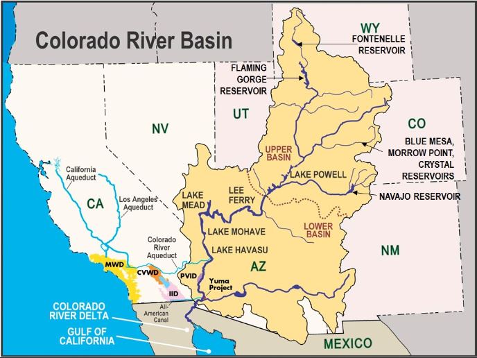
Colorado River
- The Colorado River flows from the Rocky Mountains into the southwestern US and into Mexico.
- The river is fed by snowmelt from the Rocky and Wasatch mountains and flows a distance of over 2,250 km (river Ganga flows through a distance of roughly 2,500 km) across seven states and into Mexico.
- The Colorado River Basin is divided into the Upper (Wyoming, Colorado, New Mexico, Utah and northern Arizona) and Lower Basins (parts of Nevada, Arizona, California, southwestern Utah and western New Mexico).
- In the Lower Basin, the Hoover Dam controls floods and regulates water delivery and storage.
- Apart from the Hoover dam, there is the Davis Dam, Parker Dam and the Imperial Dam that regulate the release of water from the Hoover Dam.
Major lakes in its basin
- Lake Mead is the largest reservoir in the US in terms of volume and was formed in the 1930s by the Hoover Dam in Southern Nevada.
- Its main source of water is obtained from the Rocky Mountain snowmelt and runoff.
- The other is Lake Powell, the reservoir created by the Glen Canyon Dam in Arizona.
Reasons for shortage
- Since the year 2000, this river basin has been experiencing a prolonged drought.
- This persistent drought has led to a lowering down of the water levels in the basin’s reservoirs to meet the demand over the years.
- But even with great water storing capacity, over the years the demand for water from the basin has increased whereas supply is restricted.
UPSC 2022 countdown has begun! Get your personal guidance plan now! (Click here)
Get an IAS/IPS ranker as your 1: 1 personal mentor for UPSC 2024
Attend Now
Note4Students
From UPSC perspective, the following things are important :
Prelims level: Ramsar wetlands in India
Mains level: Wetlanc conservation

Four more wetlands from India get recognition from the Ramsar Secretariat as Ramsar sites.
What are Wetlands?
- A wetland is a distinct ecosystem that is flooded by water, either permanently or seasonally, where oxygen-free processes prevail.
- The primary factor that distinguishes wetlands from other landforms or water bodies is the characteristic vegetation of aquatic plants, adapted to the unique hydric soil.
Significance of Wetlands
- Wetlands provide a wide range of important resources and ecosystem services such as food, water, fibre, groundwater recharge, water purification, flood moderation, erosion control, and climate regulation.
- They are, in fact, are a major source of water and our main supply of freshwater comes from an array of wetlands that help soak rainfall and recharge groundwater.
- They provide many societal benefits: food and habitat for fish and wildlife, including threatened and endangered species; water quality improvement; flood storage; shoreline erosion control; economically beneficial natural products for human use; and opportunities for recreation, education, and research, etc.
Which are the new sites added to the Ramsar List?
- Thol and Wadhwana from Gujarat and
- Sultanpur and Bhindawas from Haryana
With this, the number of Ramsar sites in India are 46 and the surface area covered by these sites is now 1,083,322 hectares.
(1) Bhindawas Wildlife Sanctuary
- Bhindawas WLS, the largest wetland in Haryana is a human-made freshwater wetland.
- Over 250 bird species use the sanctuary throughout the year as a resting and roosting site.
- The site supports more than ten globally threatened species including the endangered Egyptian Vulture, Steppe Eagle, Pallas’s Fish Eagle, and Black-bellied Tern.
(2) Sultanpur National Park
- Sultanpur NP from Haryana supports more than 220 species of resident, winter migratory and local migratory waterbirds at critical stages of their life cycles.
- More than ten of these are globally threatened, including the critically endangered sociable lapwing, and the endangered Egyptian Vulture, Saker Falcon, Pallas’s Fish Eagle and Black-bellied Tern.
(3) Thol Lake Wildlife Sanctuary
- Thol Lake WLS from Gujarat lies on the Central Asian Flyway and more than 320 bird species can be found here.
- The wetland supports more than 30 threatened waterbird species, such as the critically endangered White-rumped Vulture and Sociable Lapwing, and the vulnerable Sarus Crane, Common Pochard, and Lesser White-fronted Goose.
(4) Wadhvana Wetland
- Wadhvana Wetland from Gujarat is internationally important for its birdlife as it provides wintering ground to migratory waterbirds, including over 80 species that migrate on the Central Asian Flyway.
- They include some threatened or near-threatened species such as the endangered Pallas’s fish-Eagle, the vulnerable Common Pochard, and the near-threatened Dalmatian Pelican, Grey-headed Fish-eagle and Ferruginous Duck.
Back2Basics: Ramsar Convention
- The Convention on Wetlands of International Importance (better known as the Ramsar Convention) is an international agreement promoting the conservation and wise use of wetlands.
- It is the only global treaty to focus on a single ecosystem.
- The convention was adopted in the Iranian city of Ramsar in 1971 and came into force in 1975.
- Traditionally viewed as a wasteland or breeding ground of disease, wetlands actually provide fresh water and food and serve as nature’s shock absorber.
- Wetlands, critical for biodiversity, are disappearing rapidly, with recent estimates showing that 64% or more of the world’s wetlands have vanished since 1900.
- Major changes in land use for agriculture and grazing, water diversion for dams and canals, and infrastructure development are considered to be some of the main causes of loss and degradation of wetlands.
Get an IAS/IPS ranker as your 1: 1 personal mentor for UPSC 2024
Attend Now
Note4Students
From UPSC perspective, the following things are important :
Prelims level: Port of Ningbo-Zhoushan
Mains level: Not Much

China has partially shut down the world’s third-busiest container port, the Ningbo Port, after a worker there tested positive for Covid-19.
Port of Ningbo-Zhoushan
- This port is the busiest in the world in terms of cargo tonnage.
- It handled 888.96 million tons of cargo in 2015.
- The port is located in Ningbo and Zhoushan, on the coast of the East China Sea, in Zhejiang province on the southeast end of Hangzhou Bay, across which it faces the municipality of Shanghai.
- The port is at the crossroads of the north-south inland and coastal shipping route, including canals to the important inland waterway to interior China, the Yangtze River, to the north.
- The port consists of several ports which are Beilun (seaport), Zhenhai (estuary port), and old Ningbo harbour (inland river port).
What is the potential impact of the closure?
- Despite the diversion of shipments to other terminals, experts are anticipating a backlog of consignments with average wait times being expected to rise.
How is it likely to affect global trade?
- In the aftermath of Covid-19, global supply chains have remained fragile mainly on account of closures and lockdowns that affected both the manufacturing and the logistical segments of the chain.
- This has not only resulted in a growing backlog of shipments but has also caused freight charges to go up as demand outgrew the supply.
- Extended closure of one of the biggest terminals at the third-busiest port in the world could further exacerbate the stress in global trade.
Get an IAS/IPS ranker as your 1: 1 personal mentor for UPSC 2024
Attend Now
Note4Students
From UPSC perspective, the following things are important :
Prelims level: Agalega Island
Mains level: Indian ocean power competition

Mauritius has denied a report that it has allowed India to build a military base on the remote island of Agalega.
Agalega Island
- Agaléga are two outer islands of Mauritius located in the Indian Ocean, about 1,000 kilometers north of Mauritius island.
- The islands have a total area of 2,600 ha (6,400 acres).
- There is an MoU between the governments of Mauritius and India to develop the Agaléga islands and resolve infrastructural problems faced by Agaleans.
Why in news?

- India asserts that these new facilities are part of its Security and Growth for All in the Region (SAGAR) policy, which aims to increase maritime cooperation between countries in the region.
- Mauritius, for its part, has indicated that its coastguard personnel will use the new facilities.
- But it is clear that the Indian investment of $250m in developing an airfield, port, and communications hub on this remote island is not aimed at helping Mauritius develop its capacity to police its territorial waters.
Significance of this area
- The Agalega area is currently a blind spot for the Indian Navy and by building a military facility in it, New Delhi hopes to expand its maritime domain awareness.
- In times of conflict, knowing the location of enemy ships and submarines, without being detected in the process, creates a significant advantage.
- China’s naval forays into this region are the true motivator for its expanding naval presence.
- In peacetime, effective maritime domain awareness helps establish international partnerships with like-minded militaries and also acts as a deterrent to both state and non-state adversaries, by signaling reach.
Conclusion
- The Indian Ocean is now increasingly contested.
- Whether or not China is deterred by India’s surveillance efforts, Agaléga is now a pawn in this new era of major power competition across the Indian Ocean and indeed the wider Indo-Pacific region.
Get an IAS/IPS ranker as your 1: 1 personal mentor for UPSC 2024
Attend Now
Note4Students
From UPSC perspective, the following things are important :
Prelims level: South China Sea
Mains level: South China Sea Dispute

Pentagon chief has said that Beijing’s expansive claims in the South China Sea have “no basis in international law”, taking aim at China’s growing assertiveness in the hotly contested waters.
South China Sea Dispute
- It is a dispute over territory and sovereignty over ocean areas, and the Paracels and the Spratlys – two island chains claimed in whole or in part by a number of countries.
- China, Vietnam, the Philippines, Taiwan, Malaysia, and Brunei all have competing claims.
- Alongside the fully-fledged islands, there are dozens of rocky outcrops, atolls, sandbanks, and reefs, such as the Scarborough Shoal.
- China claims by far the largest portion of territory – an area defined by the “nine-dash line” which stretches hundreds of miles south and east from its most southerly province of Hainan.
- Beijing says its right to the area goes back centuries to when the Paracel and Spratly island chains were regarded as integral parts of the Chinese nation, and in 1947 it issued a map detailing its claims.
- It showed the two island groups falling entirely within its territory. Those claims are mirrored by Taiwan.
Spat over Chinese claims
- China has backed its expansive claims with island-building and naval patrols.
- The US says it does not take sides in territorial disputes but has sent military ships and planes near disputed islands, calling them “freedom of navigation” operations to ensure access to key shipping and air routes.
- Both sides have accused each other of “militarizing” the South China Sea.
- There are fears that the area is becoming a flashpoint, with potentially serious global consequences.
Get an IAS/IPS ranker as your 1: 1 personal mentor for UPSC 2024
Attend Now
Note4Students
From UPSC perspective, the following things are important :
Prelims level: Nord Stream 2 Pipeline
Mains level: Not Much

The US, which had previously imposed sanctions to prevent the completion of a major new gas pipeline between Russia and Germany, has now signaled its approval for the project.
Nord Stream 2 Pipeline
- It is a system of offshore natural gas pipelines running under the Baltic Sea from Russia to Germany.
- It includes two active pipelines running from Vyborg to Lubmin near Greifswald forming the original Nord Stream, and two further pipelines under construction running from Ust-Luga to Lubmin termed Nord Stream 2.
- In Lubmin the lines connect to the OPAL line to Olbernhau on the Czech border and to the NEL line to Rehden near Bremen.
- The first line Nord Stream-1 was laid and inaugurated in 2011 and the second line in 2012.
- At 1,222 km in length, Nord Stream is the longest sub-sea pipeline in the world, surpassing the Langeled pipeline.
Why is the pipeline controversial?
- The US believed that the project would increase Europe’s dependence on Russia for natural gas.
- Currently, EU countries already rely on Russia for 40 percent of their gas needs.
- The project also has opponents in eastern Europe, especially Ukraine, whose ties with Russia have seriously deteriorated in the aftermath of the Crimean conflict in 2014.
- There is an existing land pipeline between Russia and Europe that runs through Ukraine.
- The country feels that once Nord Storm 2 is completed, Russia could bypass the Ukrainian pipeline, and deprive it of lucrative transit fees of around $3 billion per year.
- Ukraine also fears another invasion by Russia once the new pipeline is operational.
Get an IAS/IPS ranker as your 1: 1 personal mentor for UPSC 2024
Attend Now
Note4Students
From UPSC perspective, the following things are important :
Prelims level: Great Barrier Reef
Mains level: Coral Reefs and their significance

Chinese official has said that political tensions between Beijing and Australia were not behind a UNESCO recommendation to place the Great Barrier Reef on its endangered list.
Great Barrier Reef
- The Great Barrier Reef is the world’s largest coral reef system composed of over 2,900 individual reefs and 900 islands.
- It is stretched for over 2,300 kilometres over an area of approximately 344,400 square kilometres.
- The reef is located in the Coral Sea, off the coast of Queensland, Australia.
- It was world heritage listed in 1981 by UNESCO as the most extensive and spectacular coral reef ecosystem on the planet.
Importance of Corals
Coral reefs are some of the most diverse and valuable ecosystems on Earth.
- They support more species per unit area than any other marine environment, including about 4,000 species of fish, 800 species of hard corals and hundreds of other species.
- This biodiversity is considered key to finding new medicines for the 21st century.
- Medical use: Many drugs are now being developed from coral reef animals and plants as possible cures for cancer, arthritis, human bacterial infections, viruses, and other diseases.
- Fisheries: Healthy coral reefs support commercial and subsistence fisheries as well as jobs and businesses through tourism and recreation.
- Local economies receive billions of dollars from visitors to reefs through diving tours, recreational fishing trips, hotels, restaurants, and other businesses based near reef ecosystems.
- Coral reef structures also buffer shorelines against 97 per cent of the energy from waves, storms, and floods, helping to prevent loss of life, property damage, and erosion.
Answer this PYQ in the comment box:
Q.Consider the following statements:
- Most of the world’s coral reefs are in tropical waters.
- More than one-third of the world’s coral reefs are located in the territories of Australia, Indonesia and the Philippines.
- Coral reefs host far more number of animal phyla than those hosted by tropical rainforests.
Which of the above statements is/are correct?
(a) 1 and 2 only
(b) 3 only
(c) 1 and 3 only
(d) 1 and 3 only
Back2Basisc: Coral Reef

- Coral reefs are built by and made up of thousands of tiny animals—coral “polyps”—that are related to anemones and jellyfish.
- Polyps are shallow-water organisms that have a soft body covered by a calcareous skeleton. The polyps extract calcium salts from seawater to form these hard skeletons.
- The polyps live in colonies fastened to the rocky seafloor.
- The tubular skeletons grow upwards and outwards as a cemented calcareous rocky mass collectively called corals.
- When the coral polyps die, they shed their skeleton on which new polyps grow.
- The cycle is repeated for millions of years leading to the accumulation of layers of corals shallow rock created by these depositions is called a reef.
Get an IAS/IPS ranker as your 1: 1 personal mentor for UPSC 2024
Attend Now
Note4Students
From UPSC perspective, the following things are important :
Prelims level: Lemru Elephant Reserve
Mains level: Man-Animal Conflict

The proposed Lemru Elephant Reserve in Chhattisgarh, in the pipeline for 20 years, has become the subject of yet another controversy over the reduction of its size.
Lemru Elephant Reserve
- The proposal for the reserve, in Korba district, was passed unanimously by the Assembly in 2005 and got central approval in 2007.
- Lemru is one of two elephant reserves planned to prevent human-animal conflict in the region, with elephants moving into Chhattisgarh from Odisha and Jharkhand.
- Its area was then proposed to be 450 sq km.
Why does the government want to reduce the size of the reserve?
- The area proposed under the reserve is part of the Hasdeo Aranya forests, a very diverse biozone that is also rich in coal deposits.
- Of 22 coal blocks in the area, seven have already been allotted with mines running in three, and in the process of being established in the other four.
- Under the ‘No-Go Area’ policy from the UPA area, the entire area was considered out of bounds for mines, but in 2020, five coal blocks from the region were put on the auction list.
Why is the reserve important?
- North Chhattisgarh alone is home to over 240 elephants.
- Elephants in Chhattisgarh are relatively new; they started moving into undivided Madhya Pradesh in 1990.
- Since these animals were relatively new, the human-animal conflict started once elephants started straying into inhabited areas, looking for food.
Get an IAS/IPS ranker as your 1: 1 personal mentor for UPSC 2024
Attend Now
Note4Students
From UPSC perspective, the following things are important :
Prelims level: Black Sea mapping
Mains level: Not Much

Russia accused Britain of spreading lies over a warship confrontation in the Black Sea.
What is the issue?
- Russia annexed Ukraine’s Crimean Peninsula in 2014, a move that was not recognized by most countries in the world.
- Russia has frequently responded at NATO warships visits near Crimea, casting them as destabilizing.
- NATO members Turkey, Greece, Romania and Bulgaria are in the Black Sea, but warships from the US, UK and other NATO allies also have made increasingly frequent visits in a show of support to Ukraine.
About Black Sea
- The Black Sea is a marginal sea of the Atlantic Ocean lying between Europe and Asia; east of the Balkans (Southeast Europe), south of the East European Plain in Eastern Europe, west of the Caucasus, and north of Anatolia in Western Asia.
- It is supplied by major rivers, principally the Danube, Dnieper, and Don.
- The watersheds of many countries drain into the sea beyond the six that share its coast.
- The Black Sea is bordered by Bulgaria, Georgia, Romania, Russia, Turkey, and Ukraine.
Must answer this PYQ in the comment box:
Q.Consider the following pairs:
|
Sea
|
Bordering country
|
| 1. Adriatic Sea |
Albania |
| 2. Black Sea |
Croatia |
| 3. Caspian Sea |
Kazakhstan |
| 4. Mediterranean Sea |
Morocco |
| 5. Red Sea |
Syria |
Which of the pair given above are correctly matched? (CSP 2020)
(a) 1, 2 and 4 only
(b) 1, 3 and 4 only
(c) 2 and 5 only
(d) 1, 2, 3, 4 and 5
Get an IAS/IPS ranker as your 1: 1 personal mentor for UPSC 2024
Attend Now