Note4Students
From UPSC perspective, the following things are important :
Prelims level: MEE Survey
Mains level: Not Much
Minister for Environment, Forest and Climate Change has released Management Effectiveness Evaluation (MEE) of 146 national parks and wildlife sanctuaries in the country.
Map the protected areas mentioned in the newscard in your Atlas.
MEE Survey
- MEE is a very important document that provides valuable guidance on various aspects of wildlife and protected area expand MEE of Marine Protected Areas.
- In order to assess the efficacy of Protected Areas, evaluation of management effectiveness was required.
- MEE has emerged as a key tool for PA managers and is increasingly being used by governments and international bodies to understand the strengths and weaknesses of the protected area management systems.
- The results of the present assessment are encouraging with an overall mean MEE score of 62.01% which is higher than the global mean of 56%.
- With this round of evaluation, MoEFCC successfully completed one full cycle of evaluating all terrestrial National Parks and Wildlife Sanctuaries of the country from 2006 to 2019.
India has systematically designated its Protected Areas in four legal categories — National Parks, Wildlife Sanctuaries, Conservation Reserves and Community Reserves under the Wildlife (Protection) Act, 1972.
Areas surveyed
- Under the WP 1972 Act, India has 903 formally designated Protected Areas with total coverage of 1,65,012.6 square km.
- Among these are 101 National Parks, 553 Wildlife Sanctuaries, 86 Conservation Reserves and 163 Community Reserves.
- For the survey, 146 National Parks and Wildlife Sanctuaries across 29 states and Union territories were evaluated.
Highlights of the MEE
- Tirthan Wildlife Sanctuary and Great Himalayan National Park in Himachal Pradesh have performed the best among the surveyed protected areas.
- The Turtle Wildlife Sanctuary in Uttar Pradesh was the worst performer in the survey.
Get an IAS/IPS ranker as your 1: 1 personal mentor for UPSC 2024
Attend Now
Note4Students
From UPSC perspective, the following things are important :
Prelims level: Kalyana Chalukya Style of Architecture
Mains level: Temple Architecture of India

Karnataka CM has laid the foundation stone for the ‘New Anubhava Mantapa’ in Basavakalyan, the place where 12th-century poet-philosopher Basaveshwara lived for most of his life.
Vaishnavism and Shaivism are the two most profound strands of Bhakti Movement in Indian history. Enlist all the Bhakti Saints and their theistic philosophy and teachings. Try to spot the minute differences between them.
Who was Basaveshwara?
- Basaveshwara or Basavanna was an Indian 12th-century statesman, philosopher, a poet and Lingayat saint in the Shiva-focussed Bhakti movement and a social reformer in Karnataka.
- He lived during the reign of the Kalyani Chalukya/Kalachuri dynasty.
- He was active during the rule of both dynasties but reached his peak of influence during the rule of King Bijjala II in Karnataka, India.
Founder of Lingayat cult
- The traditional legends and hagiographic texts state Basava to be the founder of the Lingayats.
- However, modern scholarship relying on historical evidence such as the Kalachuri inscriptions state that Basava was the poet-philosopher who revived, refined and energized an already existing tradition.
His Philosophy
- Basava’s Lingayat theology was a form of qualified nondualism, wherein the individual Atman (soul) is the body of God, and that there is no difference between Shiva and Atman (self, soul).
- Basava’s views find places in Vedanta school, in a form closer to the 11th-century Vishishtadvaita philosopher Ramanuja.
Famous works
- Basavanna spread social awareness through his poetry, popularly known as Vachanaas.
- Basavanna rejected gender or social discrimination, superstitions and rituals but introduced Ishtalinga necklace, with an image of the Shiva Liṅga to every person regardless of his or her birth.
- As the chief minister of his kingdom, he introduced new public institutions such as the Anubhava Mantapa (or, the “hall of spiritual experience”) which welcomed men and women from all socio-economic backgrounds.
The New Anubhava Mantapa
- The New Anubhava Mantapa, as envisaged now, will be a six-floor structure in the midst of the 7.5-acre plot and represent various principles of Basaveshwara
- It will showcase the 12th Century Anubhava Mantapa (often referred to as the “first Parliament of the world”) established by him in Basavakalyan where philosophers and social reformers held debates.
- The building will adopt the Kalyana Chalukya style of architecture.
- The grand structure supported by 770 pillars will have an auditorium with a seating capacity of 770 people.
- It is believed that 770 Sharanas (followers of Basaveshwara) led the Vachana reformist movement in the 12th Century.
- The basement is designed for a Dasoha Bhavana (dining hall) where around 1,500 people eat together. On its top, the structure would have a Linga placed on a large pedestal.
- The project also envisages a state-of-the-art robotic system, open-air theatre, modern water conservation system, terrace garden, library, research centre, prayer hall, yoga centre and so on.
Back2Basics: Kalyana Chalukya Style of Architecture
- It is the distinctive style of ornamented architecture that evolved during the rule of the Western Chalukya Empire in the Tungabhadra region of modern central Karnataka.
- These monuments, regional variants of pre-existing Dravida (South Indian) temples, form a climax to the wider regional temple architecture tradition called Vesara or Karnata Dravida.
- They are either Ekakuta (one mandapa of one shrine) or Dvikuta (a common hall attached to two shrines).
- The style has characters of both the Northern as well as Dravidian temple architecture.
- This combination of both of these styles is known as Vesara Style, also Central Indian Style, which is represented by the Hoysala Temples.
- Most of the temples of the Western Chalukyas are dedicated to Shiva, some of them dedicated to Vishnu and Jain Tirthankars also.
Examples: Truketshwara Temple, Gadag; Kasivisvesvara Temple, Lakkundi
Get an IAS/IPS ranker as your 1: 1 personal mentor for UPSC 2024
Attend Now
Note4Students
From UPSC perspective, the following things are important :
Prelims level: Ramsar Convention, Wetlands
Mains level: Ramsar wetlands in India

Assam has prohibited community fishing at Deepor Beel, a wetland on the south-western edge of Guwahati and it’s the only Ramsar site.
Try this PYQ:
In which one among the following categories of protected areas in India are local people not allowed to collect and use the biomass?
(a) Biosphere reserves
(b) National parks
(c) Wetlands declared under Ramsar convention
(d) Wildlife sanctuaries
Deepor Beel
- Deepor Beel is located to the south-west of Guwahati city, in Kamrup district of Assam, India.
- It is a permanent freshwater lake, in a former channel of the Brahmaputra River, to the south of the main river.
- It is a wetland under the Ramsar Convention which has listed since November 2002, for undertaking conservation measures on the basis of its biological and environmental importance.
- Considered as one of the largest beels in the Brahmaputra valley of Lower Assam, it is categorised as a representative of the wetland type under the Burma monsoon forest biogeographic region.
- It is also an important bird sanctuary habituating many migrant species.
- Freshwater fish is a vital protein and source of income for these communities; the health of these people is stated to be directly dependent on the health of this wetland ecosystem.
Back2Basics: Ramsar Convention
- The Convention on Wetlands of International Importance (better known as the Ramsar Convention) is an international agreement promoting the conservation and wise use of wetlands.
- It is the only global treaty to focus on a single ecosystem.
- The convention was adopted in the Iranian city of Ramsar in 1971 and came into force in 1975.
- Traditionally viewed as a wasteland or breeding ground of disease, wetlands actually provide fresh water and food and serve as nature’s shock absorber.
- Wetlands, critical for biodiversity, are disappearing rapidly, with recent estimates showing that 64% or more of the world’s wetlands have vanished since 1900.
- Major changes in land use for agriculture and grazing, water diversion for dams and canals and infrastructure development are considered to be some of the main causes of loss and degradation of wetlands.
Get an IAS/IPS ranker as your 1: 1 personal mentor for UPSC 2024
Attend Now
Note4Students
From UPSC perspective, the following things are important :
Prelims level: Dibru-Saikhowa National Park
Mains level: Not Much

PC: Gmaps
Assam has asked the State’s Forest and Revenue departments to permanently rehabilitate the indigenous forest dwellers of the Dibru-Saikhowa National Park.
Try this PYQ from CSP 2019:
Q. Which of the following are in Agasthyamalai Biosphere Reserve?
(a) Neyyar, Peppara and Shendurney Wildlife Sanctuaries; and Kalakad Mundanthurai Tiger Reserve
(b) Mudumalai, Sathyamangalam and Wayanad Wildlife Sanctuaries; and Silent Valley National Park
(c) Kaundinya, Gundla Brahme-swaram and Papikonda Wildlife Sanctuaries; and Mukurthi National Park
(d) Kawal and Sri Venkateswara Wildlife Sanctuaries; and Nagarjunasagar-Srisailam Tiger Reserve
Dibru-Saikhowa National Park
- DSNP is a national park in Assam located in Dibrugarh and Tinsukia districts.
- It was designated a Biosphere Reserve in July 1997 with an area of 765 sq. km.
- The park is bounded by the Brahmaputra and Lohit Rivers in the north and the Dibru river in the south.
- It mainly consists of moist mixed semi-evergreen forests, moist mixed deciduous forests, canebrakes, and grasslands.
- It is the largest Salix swamp forest in north-eastern India, with a tropical monsoon climate with a hot and wet summer and cool and usually dry winter.
Why in news?
- Rehabilitation of some 10,000 people has been hanging fire since 1999 when the Dibru-Saikhowa Wildlife Sanctuary was upgraded to a national park.
- The park, home to a few wild horses, had been in focus since May when a blowout at an Oil India Limited gas well in the vicinity posed an ecological threat.
What is the issue?
- The affected people belong to the Missing community.
- The forest dwellers of the 425-sq. km. Dibru-Saikhowa National Park has been denied access to government schemes since 1986 through a notification.
- It allowed them to continue staying until their shifting to a suitable place.
- The organization said the villagers’ problems started when 765 sq. km. around their habitations was declared a biosphere reserve in 1997, limiting the access of the forest to the community.
- The hardship compounded in 1999 when the national park came into existence.
Get an IAS/IPS ranker as your 1: 1 personal mentor for UPSC 2024
Attend Now
Note4Students
From UPSC perspective, the following things are important :
Prelims level: Sea of Galilee
Mains level: Not Much

The Sea of Galilee, well-known in Jewish, Christian, and Islamic lore, has swelled up due to recent rains, according to reports in the Israeli media.
Do you know?
The Sea of Galilee Lake Tiberias, Kinneret or Kinnereth is a freshwater lake in Israel. It is the lowest freshwater lake on Earth and the second-lowest lake in the world (after the Dead Sea, a saltwater lake).
Sea of Galilee
- The lake lies in northern Israel, between the occupied Golan Heights and the Galilee region. It is fed by underground springs but its major source is the Jordan River.
- The lake has risen to 209.905 meters below sea level due to heavy rainfall in the surrounding areas.
- The Jordan flows into the lake and then exits it before ending in the Dead Sea, the saltiest and the lowest point on the planet.
- Water is not extracted from the Sea of Galilee. But it is considered to be an important barometer of the water situation in Israel.
Get an IAS/IPS ranker as your 1: 1 personal mentor for UPSC 2024
Attend Now
Note4Students
From UPSC perspective, the following things are important :
Prelims level: Navratnas of Akbar
Mains level: Medieval arts and culture

This newscard is an excerpt from the original article published in The Hindu.
Try this PYQ:
Q.With reference to Mian Tansen, which one of the following statements is not correct?
(a) Tansen was the title given to him by Emperor Akbar.
(b) Tansen composed Dhrupads on Hindu gods and goddesses.
(c) Tansen composed songs on his patrons.
(d) Tansen invented many Ragas.
Who was Rahim?
- Dating back to 1598, during the rule of Akbar, Abdur Rahim Khan I Khanan was one of the Navratna in the court.
- Winning wars with his military training and hearts with his dohas and translated texts — he was a man who survived despite his father Bairam Khan’s assassination when he was just four.
- Meant to be a dedication of a husband to his wife, the tomb ended up housing his own remains too when he died in 1627.
His works
- Apart from writing various dohas, Rahim translated Babar’s memoirs, Baburnama from Chagatai language to the Persian language, which was completed in 998 (1589–90) AD.
- He had an excellent command over the Sanskrit language.
- In Sanskrit, he wrote two books on astrology, Khetakautukam and Dwatrimshadyogavali.
Why in news?
- The tomb is in a run-down situation but undergoing renovation.
- The historical and cultural significance is more than the archaeological and architectural significance, so restoring the dignity of the burial place has been very important.
Get an IAS/IPS ranker as your 1: 1 personal mentor for UPSC 2024
Attend Now
Note4Students
From UPSC perspective, the following things are important :
Prelims level: Caspian Sea
Mains level: Ecocides and their impact

The Caspian is actually a lake, the largest in the world and it is experiencing a devastating decline in its water level that is about to accelerate.
Note the countries bordering the Caspian Sea: Kazakhstan, Russia, Azerbaijan, Iran and Turkmenistan. Or else remember the acronym ‘TARIK(h)’ (Hindi word for date).
You can frame a mnemonic statement of your choice. Do similarly for major lakes and inland seas. But dont let it move over TARIK pe TARIK!
Caspian Sea
- The Caspian Sea is the world’s largest inland body of water, variously classed as the world’s largest lake or a full-fledged sea.
- As an endorheic basin, it lies between Europe and Asia.
- An endorheic basin is a drainage basin that normally retains water and allows no outflow to other external bodies of water, such as rivers or oceans, but converges instead into lakes or swamps, permanent or seasonal that equilibrates through evaporation
- Its level is the product of how much water is flowing in from rivers, mostly the mighty Volga to the north, how much it rains and how much evaporates away.
- At the end of the century, the Volga and other northern rivers will still be there.
- However, a projected temperature rise of about 3℃ to 4℃ in the region will drive evaporation through the roof.
Now try this PYQ:
Q.Which of the following has/have shrunk immensely/ dried up in the recent past due to human activities?
- Aral Sea
- Black Sea
- Lake Baikal
Select the correct option using the code given below:
(a) 1 only
(b) 2 and 3 only
(c) 2 only
(d) 1 and 3 only
Why in news?

- By the end of the century, the Caspian Sea will be nine metres to 18 metres lower. That’s a depth considerably taller than most houses.
- The Caspian’s surface is already dropping by 7 cm every year, a trend likely to increase.
- It means the lake will lose at least 25 per cent of its former size, uncovering 93,000 sq km of dry land.
- If that new land were a country, it would be the size of Portugal.
Past strides in its level
- The Caspian Sea has a history of violent rises and falls.
- In Derbent, on the Caucasus coast of Russia, submerged ancient city walls testify to how low the sea was in medieval times.
- Around 10,000 years ago, the Caspian was about 100 metres lower.
- A few thousand years before that it was about 50 metres higher than today and even over spilt into the Black Sea.
Get an IAS/IPS ranker as your 1: 1 personal mentor for UPSC 2024
Attend Now
Note4Students
From UPSC perspective, the following things are important :
Prelims level: KG basin, Natural Gas
Mains level: Oil and gas reserves in KG basin

Reliance Industries Ltd and BP (British Petroleum) have announced the start of gas production from the R cluster of the KG Basin, the deepest off-shore gas field in Asia.
Must read
https://www.civilsdaily.com/burning-issue-natural-gas-marketing-reforms/
Krishna-Godavari Basin
- The Krishna Godavari Basin is a proven petroliferous basin of continental margin located on the east coast of India.
- Its onland part covers an area of 15000 sq. km and the offshore part covers an area of 25,000 sq. km up to 1000 m isobath.
- The basin contains about 5 km thick sediments with several cycles of deposition, ranging in age from Late Carboniferous to Pleistocene.
- The major geomorphologic units of the Krishna Godavari basin are Upland plains, Coastal plains, Recent Flood and Delta Plains.
Minerals found
- KG inland and offshore basins have good prospects of tight oil and tight gas reserves from the conducted field studies.
- The first gas discovery in the basin was in 1983.
- Most of the conventional wells drilled and operated have a shorter lifespan than envisaged life and with erratic production.
- This may be due to drilling of conventional wells in tight oil and gas fields without horizontal drilling in the shale rock formations and hydraulic fracturing.
Note: Tight gas and tight oil are produced from reservoir rocks with such low permeability that considerable hydraulic fracturing is required to harvest the well at economic rates.
The KGD6 block

- Krishna Godavari Dhirubhai 6 (KG-D6) was Reliance’s first offshore gas field development and its first underwater discovery.
- It was also India’s largest deposit of natural gas and the largest such discovery in the world in 2002.
- The project takes its name from India’s Krishna-Godavari Basin, which covers more than 19,000 square miles (50,000 square kilometres) in Andhra Pradesh and production block D6 in the Bay of Bengal.
Why is this important?
- The R cluster, along with the Satellite Cluster and MJ gas fields in the KG Basin is expected to produce around 30 MMSCMD (million standard cubic metres per day) of natural gas.
- This is about 15% of India’s projected demand for natural gas by 2023.
Do they impact India’s energy security efforts?
- The three projects are a key part of the plan to boost domestic production of natural gas to increase the share of natural gas in India’s energy basket from 6.2% now to 15% by 2030.
- Increased domestic production of natural gas is an important aspect of reducing India’s dependence on imports and improves energy security.
Get an IAS/IPS ranker as your 1: 1 personal mentor for UPSC 2024
Attend Now
Note4Students
From UPSC perspective, the following things are important :
Prelims level: Pobitora WLS, Kaziranga NP
Mains level: Rhino protection measures
Too many cattle are robbing the one-horned rhinos of Assam’s Pobitora Wildlife Sanctuary, referred to as ‘Mini Kaziranga’ for similar features, of their nutritious food.
Try this PYQ:
Q. Consider the following statements:
- Asiatic lion is naturally found in India only.
- Double-humped camel is naturally found in India only.
- One-horned rhinoceros is naturally found in India only.
Which of the statements given above is/are correct?
(a) 1 only
(b) 2 only
(c) 1 and 3 only
(d) 1, 2 and 3
About Pobitora Wildlife Sanctuary
- Pobitora WLS is located on the southern bank of the Brahmaputra in Morigaon district in Assam.
- It was declared in 1987 and covers 38.85 km2 (15.00 sq mi), providing grassland and wetland habitat for the Indian rhinoceros.
- It provides a habitat and food resource for the Indian rhinoceros, hosting Assam’s second-largest population.
- Other mammals occurring in the sanctuary are golden jackal, wild boar and feral water buffalo.
- Barking deer, Indian leopard and rhesus macaque live foremost in the hilly parts. It is an Important Bird Area and home for more than 2000 migratory birds and various reptiles.
Why in news?
- Pobitora is running a successful Rhino breeding program within its sanctuary.
- It is running under the government as “Indian Rhino vision 2020”.
Back2Basics: Kaziranga National Park and Tiger Reserve
- The KNTPR is a national park in the Golaghat, Karbi Anglong and Nagaon districts of the state of Assam.
- The sanctuary, which hosts two-thirds of the world’s great one-horned rhinoceroses, is a World Heritage Site.
- Kaziranga is home to the highest density of tigers among protected areas in the world and was declared a Tiger Reserve in 2006 (now the highest tiger density is in Orang National Park, Assam).
- The park is home to large breeding populations of elephants, wild water buffalo, and swamp deer.
- It is also recognized as an Important Bird Area by BirdLife International for the conservation of avifaunal species.
Get an IAS/IPS ranker as your 1: 1 personal mentor for UPSC 2024
Attend Now
Note4Students
From UPSC perspective, the following things are important :
Prelims level: Vijayanagara architecture
Mains level: Vijayanagara architecture

Tourists can no longer get too close to the iconic stone chariot in front of the Vijaya Vittala Temple due to a protective ring by the Archaeological Survey of India (ASI).
Try this question from CSP 2019:
Q.Building ‘Kalyaana Mandapas’ was a notable feature in the temple construction in the kingdom of
(a) Chalukya
(b) Chandela
(c) Rashtrakuta
(d) Vijayanagara
The Vijayanagara Capital: Hampi

- Hampi or Hampe, also referred to as the Group of Monuments at Hampi, is a UNESCO World Heritage Site located in east-central Karnataka.
- Hampi was the capital of the Vijayanagara Empire in the 14th century.
- The old city of Hampi was a prosperous, wealthy and grand city near the Tungabhadra River, with numerous temples, farms and trading markets.
- By 1500 CE, Hampi-Vijayanagara was the world’s second-largest medieval-era city after Beijing, and probably India’s richest at that time, attracting traders from Persia and Portugal.
- The Vijayanagara Empire was defeated by a coalition of sultanates; its capital was conquered, pillaged and destroyed by sultanate armies in 1565, after which Hampi remained in ruins.
Major attractions
- The Krishna temple complex, Narasimha, Ganesa, Hemakuta group of temples, Achyutaraya temple complex, Vitthala temple complex, Pattabhirama temple complex, Lotus Mahal complex, can be highlighted.
- Suburban townships (puras) surrounded the large temple complexes contains subsidiary shrines, bazaars, residential areas and tanks applying the unique hydraulic technologies.
- The Vitthla temple is the most exquisitely ornate structure on the site and represents the culmination of Vijayanagara temple architecture.
- It is a fully developed temple with associated buildings like Kalyana Mandapa and Utsava Mandapa within a cloistered enclosure pierced with three entrance Gopurams.
- In addition to the typical spaces present in contemporary temples, it boasts of a Garuda shrine fashioned as a granite ratha and a grand bazaar street.
Get an IAS/IPS ranker as your 1: 1 personal mentor for UPSC 2024
Attend Now
Note4Students
From UPSC perspective, the following things are important :
Prelims level: Bhashan Char Island and its location
Mains level: Rohingya Crisis

Bangladesh has transported more than 1,600 Rohingya refugees to a low-lying island in the first phase of a controversial planned relocation of 1,00,000 people.
Can you see, what the so-called champions of tolerance and human rights doing to the refugees in their own country!
Bhashan Char Island
- Bhasan Char also known as Char Piya, is an island in Hatiya, Bangladesh.
- Located 34 kilometres (21 miles) from the mainland, its name in Bengali means “floating island.”
- The island was formed with Himalayan silt in 2006 spanning 40 square kilometres.
- It is underwater from June to September annually because of the monsoon, and it has no flood fences.
- In June 2015, the Bangladeshi government suggested resettling Rohingya refugees on the island under its Ashrayan Project.
- The proposal was characterized by the UN Refugee Agency as “logistically challenging”.
Extraditing to another hell
- Bhashan Char is a flood-prone island that emerged from the sea 20 years ago.
- The refugees had been coerced into going to this flood-prone island which is also vulnerable to frequent cyclones.
- This compact island is too small to occupy and nurture the Rohingya population and there is chronic overcrowding in camps.
Get an IAS/IPS ranker as your 1: 1 personal mentor for UPSC 2024
Attend Now
Note4Students
From UPSC perspective, the following things are important :
Prelims level: Mt. Vesuvious, volacanic landforms
Mains level: Not Much

The Italian Culture Ministry announced the discovery of well-preserved remains of two men, who perished during the volcanic eruption of Mount Vesuvius in 79 AD.
Try this PYQ:
Q.Consider the following statements:
- The Barren Island volcano is an active volcano located in the Indian Territory.
- Barren Island lies about 140 km east of Great Nicobar.
- The last time the Barren Island volcano erupted was in 1991 and it has remained inactive since then.
Which of the statements given above is/are correct?
(a) 1 only
(b) 2 and 3 only
(c) 3 only
(d) 1 and 3 only
Mount Vesuvius
- Located in southern Italy near the coastal city of Naples, the 4,203-ft (1,281 metres) tall Vesuvius is the only active volcano in mainland Europe.
- Vesuvius has been classified as a complex volcano (also called a compound volcano), one that consists of a complex of two or more vents.
- It typically has explosive eruptions and pyroclastic flows –– defined as a high-density mix of hot lava blocks, pumice, ash and volcanic gas.
- It has erupted more than 50 times and is considered among the most dangerous volcanoes in the world due to its proximity to Naples and surrounding towns.
- Its last serious eruption, lasting two weeks, was in 1944 during World War II, which left 26 Italian civilians dead and around 12,000 displaced.
The eruption of 79 AD
- In 79 AD, the Roman Empire-era sister cities of Pompeii and Herculaneum were destroyed and buried during a catastrophic eruption of Vesuvius.
- It was a catastrophic event that destroyed the ancient Roman city of Pompeii and killed around 16,000 people.
- Pompeii, 8 km away from Vesuvius, served as a resort town on the Bay of Naples for Rome’s elite citizens, consisting of villas, cafes, marketplaces and a 20,000-seat arena.
- In 63 AD, a major earthquake rattled the city, serving as a warning for the eruption to come. However, few residents bothered to abandon the region, known for its volatility.
Get an IAS/IPS ranker as your 1: 1 personal mentor for UPSC 2024
Attend Now
Note4Students
From UPSC perspective, the following things are important :
Prelims level: Location of Luxembourg
Mains level: Not Much

Prime Minister has pitched for strengthening ties to further ramp up economic engagement between India and Luxembourg.
Mark the location of Luxembourg. Since it is a landlocked country, there can be a question asking its bordering states.
Luxembourg
- Luxembourg is a small European country, landlocked by Belgium, France and Germany.
- It’s mostly rural, with dense Ardennes forest and nature parks in the north, rocky gorges of the Mullerthal region in the east and the Moselle river valley in the southeast.
- Its capital, Luxembourg City, is famed for its fortified medieval old town perched on sheer cliffs
Why Luxembourg?
- Luxembourg is one of the most important financial centres globally.
- Several Indian companies have raised capital by issuing Global Depositary Receipts at the Luxembourg Stock Exchange.
- Luxembourg-based investment funds hold substantial banking and asset management market share in portfolio investments in India.
- It is also the third-largest source of Foreign Portfolio Investments (FPI) in India.
Get an IAS/IPS ranker as your 1: 1 personal mentor for UPSC 2024
Attend Now
Note4Students
From UPSC perspective, the following things are important :
Prelims level: Ramsar sites in India
Mains level: Wetland conservation in India
The Lonar Lake in Maharashtra and Sur Sarovar, also known as Keetham lake, in Agra, have been added to the list of recognised Ramsar sites.
Make a note of all freshwater and saltwater lakes in India.
Lonar Lake
- Lonar Lake, also known as Lonar crater, is a notified National Geo-heritage Monument, saline (pH of 10.5), Soda Lake, located at Lonar in Buldhana district, Maharashtra.
- It was created by an asteroid collision with earth impact during the Pleistocene Epoch.
- It is one of the four known, hyper-velocity, impact craters in basaltic rock anywhere on Earth.
- It sits inside the Deccan Plateau—a massive plain of volcanic basalt rock created by eruptions some 65 million years ago.
Sur Sarovar
- It is a scenic lake just outside Agra on the Agra – Delhi highway (NH 2) and a declared bird sanctuary.
- The riverine belt of River Yamuna surrounds the area of Sur-Sarovar.
- It is today home to more than 165 species of migratory and resident birds.
- It is the same place that inspired the famed poet Soordas to compose the “Bhakti Kavya” one of the finest pieces of devotional poetry.
Two amongst many
- India now has 41 wetlands, the highest in South Asia, with two more added to the list of recognised sites of international importance under the treaty of Ramsar Convention.
- Recently, Kabartal in Bihar’s Begusarai district was recognised as a wetland of international importance, the first such wetland in the State, under the Ramsar Convention.
- The Asan Conservation Reserve in Dehradun, the first wetland from Uttarakhand to be recognised by Ramsar convention, was added to the list in October this year.
Back2Basics: Wetlands
- A wetland is a distinct ecosystem that is flooded by water, either permanently or seasonally, where oxygen-free processes prevail.
- The primary factor that distinguishes wetlands from other landforms or water bodies is the characteristic vegetation of aquatic plants, adapted to the unique hydric soil.
- Wetlands provide a wide range of important resources and ecosystem services such as food, water, fibre, groundwater recharge, water purification, flood moderation, erosion control and climate regulation.
What is the Ramsar Convention?
- The Ramsar Convention on Wetlands of International Importance Especially as Waterfowl Habitat is a treaty for the conservation and sustainable use of such sites.
- The convention, signed in 1971 in the Iranian city of Ramsar, is one of the oldest inter-governmental accords for preserving the ecological character of wetlands.
- Also known as the Convention on Wetlands, it aims to develop a global network of wetlands for the conservation of biological diversity and for sustaining human life.
- Over 170 countries are party to the Ramsar Convention and over 2,000 designated sites covering over 20 crore hectares have been recognised under it.
Get an IAS/IPS ranker as your 1: 1 personal mentor for UPSC 2024
Attend Now
Note4Students
From UPSC perspective, the following things are important :
Prelims level: Nagorno-Karabakh region
Mains level: Usual crisis in the middle east and caucasus region

Armenia and Azerbaijan agreed on a deal with Russia to end fierce clashes over Nagorno-Karabakh after a string of Azerbaijani victories in its fight to retake the disputed region.
Ending up the bloodshed
- During the course of the conflict, over 1200 have lost their lives as per the Nagorno-Karabakh authorities, while thousands have been displaced.
- Since the conflict started in September, multiple ceasefire agreements have been signed between the two sides, but none so far have been successful.
- The deal is meant to end the conflict between the two nations.
- Russia’s role in the conflict has been somewhat opaque since it supplies arms to both countries and is in a military alliance with Armenia called the Collective Security Treaty Organisation.
What is the Nagorno-Karabakh region?
- Straddling western Asia and Eastern Europe, Nagorno-Karabakh is internationally recognised as part of Azerbaijan, but most of the region is controlled by Armenian separatists.
- It has been part of Azerbaijan territory since the Soviet era.
- When the Soviet Union began to collapse in the late 1980s, Armenia’s regional parliament voted for the region’s transfer to Armenia; the Soviet authorities turned down the demand.
- Years of clashes followed between Azerbaijan forces and Armenian separatists.
- The violence lasted into the 1990s, leaving tens and thousands dead and displacing hundreds of thousands.
- In 1994, Russia brokered a ceasefire, by which time ethnic Armenians had taken control of the region.
Consider this PYQ:
Q.The area is known as ‘Golan Heights’ sometimes appears in the news in the context of the events related to: (CSP 2015)
a) Central Asia
b) Middle East
c) South-East Asia
d) Central Africa
Who controls it?
- While the area remains in Azerbaijan, it is today governed by separatist Armenians who have declared it a republic called the “Nagorno-Karabakh Autonomous Oblast”.
- While the Armenian government does not recognise Nagorno-Karabakh as independent, it supports the region politically and militarily.
Ethnicity and the conflict
- Ethnic tensions from decades ago have a crucial role in the dispute.
- While the Azeris claim that the disputed region was under their control in known history, Armenians maintain that Karabakh was a part of the Armenian kingdom.
- At present, the disputed region consists of a majority Armenian Christian population, even though it is internationally recognised as a part of Muslim-majority Azerbaijan.
Get an IAS/IPS ranker as your 1: 1 personal mentor for UPSC 2024
Attend Now
Note4Students
From UPSC perspective, the following things are important :
Prelims level: Kartarpur Corridor, Nirguna cult
Mains level: Piligrimage diplomacy between India and Pakisatan
Pakistan has decided to transfer the management of the Kartarpur Sahib Gurudwara from a Sikh body to a separate trust, saying it runs against the religious sentiments of the Sikh community.
Try this PYQ:
Consider the following Bhakti Saints:
- Dadu Dayal
- Guru Nanak
- Tyagaraja
Who among the above was/were preaching when the Lodi dynasty fell and Babur took over?
(a) 1 and 3
(b) 2 only
(c) 2 and 3
(d) 1 and 2
Kartarpur Corridor

- The Kartarpur corridor connects the Darbar Sahib Gurdwara in Narowal district of Pakistan with the Dera Baba Nanak shrine in Gurdaspur district in India’s Punjab province.
- The first guru of Sikhism, Guru Nanak, founded Kartarpur in 1504 AD on the right bank of the Ravi River. The name Kartarpur means “Place of God”.
- The corridor is being built to commemorate 550th birth anniversary celebrations of Guru Nanak Dev, founder of Sikhism on 12th November 2019.
About Guru Nanak
- Guru Nanak Dev (1469-1539) also referred to as Baba Nanak was the founder of Sikhism and is the first of the ten Sikh Gurus.
- He advocated the ‘Nirguna’ form of Bhakti. He rejected sacrifices, ritual baths, image worship, austerities and the scriptures of both Hindus and Muslims.
- He appointed one of his disciples, Angad, to succeed him as the preceptor (guru), and this practice was followed for nearly 200 years.
- The fifth preceptor, Guru Arjan, compiled his hymns along with those of his four successors and also other religious poets, like Baba Farid, Ravidas and Kabir, in the Adi Granth Sahib.
Get an IAS/IPS ranker as your 1: 1 personal mentor for UPSC 2024
Attend Now
Note4Students
From UPSC perspective, the following things are important :
Prelims level: Mansar Lakes, Ramsar Sites
Mains level: Wetland conservation in India
Mansar Lake Development Plan is getting fulfilled after a long wait of 70 years.
Try this PYQ:
Q.With reference to a conservation organization called Wetlands International, which of the following statements is/are correct?
- It is an intergovernmental organization formed by the countries which are signatories to Ramsar Convention.
- It works at the field level to develop and mobilize knowledge, and use the practical experience to advocate for better policies.
Select the correct answer using the code given below:
(a) 1 only
(b) 2 only
(c) Both 1 and 2
(d) Neither 1 nor 2
About Mansar Lake
- Situated at about 37 km from Jammu, Mansar is a lake fringed by forest-covered hills, over a mile in length by half-a-mile in width.
- Surinsar-Mansar Lakes are designated as Ramsar Convention in November 2005.
- With all religions belief and heritage behind the Mansar Lake is also picking up its fame among the tourists with all its flora & fauna.
- The lake has cemented path all around with required illumination, with projected view decks to enjoy flickering of seasonal birds, tortoise and fishes of different species.
- There is a wildlife Sanctuary housing jungle life like Spotted Deer, Nilgai etc. besides other water birds such as Cranes, Ducks etc.
Back2Basics: Ramsar Convention
- The Convention on Wetlands of International Importance (better known as the Ramsar Convention) is an international agreement promoting the conservation and wise use of wetlands.
- It is the only global treaty to focus on a single ecosystem.
- The convention was adopted in the Iranian city of Ramsar in 1971 and came into force in 1975.
- Traditionally viewed as a wasteland or breeding ground of disease, wetlands actually provide freshwater and food and serve as nature’s shock absorber.
- Wetlands, critical for biodiversity, are disappearing rapidly, with recent estimates showing that 64% or more of the world’s wetlands have vanished since 1900.
- Major changes in land use for agriculture and grazing, water diversion for dams and canals and infrastructure development are considered to be some of the main causes of loss and degradation of wetlands.
Get an IAS/IPS ranker as your 1: 1 personal mentor for UPSC 2024
Attend Now
Note4Students
From UPSC perspective, the following things are important :
Prelims level: Taiwan strait
Mains level: Not Much

A U.S. warship sailed through the Taiwan Strait in what the American military described as a “routine” passage on but enraging China, which claims sovereignty over the island and surrounding seas.
Try this PYQ:
Q.Which one of the following can one come across if one travels through the Strait of Malacca?
(a) Bali
(b) Brunei
(c) Java
(d) Singapore
Taiwan Strait
- The Taiwan Strait, also known as the Formosa Strait, is a 180 km wide strait separating Taiwan and mainland China.
- The strait is currently part of the South China Sea and connects to the East China Sea to the north. The narrowest part is 130 km wide.
- The entire strait is on Asia’s continental shelf.
- Historically both the People’s Republic of China (PRC) and Taiwan espoused a One-China Policy that considered the strait part of the exclusive economic zone of a single “China”.
Tap to read more about One China Policy at:
Get an IAS/IPS ranker as your 1: 1 personal mentor for UPSC 2024
Attend Now
Note4Students
From UPSC perspective, the following things are important :
Prelims level: Zojila Pass
Mains level: Road infrastructure in Himalayas
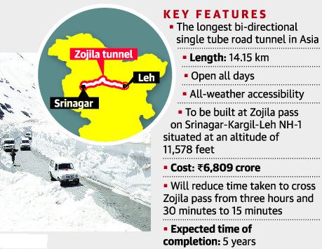
Union Transport Ministry has launched the first blasting for construction-related work at the Zojila tunnel that will provide all-year connectivity between Srinagar valley and Leh.
These days various Himalayan passes and tunnels are overwhelmingly seen in news. Open your Atlas and try to spot all of them for now and once before the exam.
Zojila Tunnel
- The Zojila is set to be Asia’s longest bi-directional tunnel.
- It will connect Srinagar, Dras, Kargil and Leh via a tunnel through the famous Zojila Pass.
- Located at more than 11,500 feet above sea level, the all-weather Zojila tunnel will be 14.15 km long and ensure road connectivity even during winters.
- It will make the travel on the 434-km Srinagar-Kargil-Leh Section of NH-1 free from avalanches, enhance safety and reduce the travel time from more than 3 hours to just 15 minutes.
- The speed limit inside the tunnel is likely to be the same as in the Atal tunnel – 80 kmph.
Its significance
- The project holds strategic significance as Zojila Pass is situated at an altitude of 11,578 feet on the Srinagar-Kargil-Leh National Highway and remains closed during winters due to heavy snowfall.
- At present, it is one of the most dangerous stretches in the world to drive a vehicle and this project is also geo-strategically sensitive.
Get an IAS/IPS ranker as your 1: 1 personal mentor for UPSC 2024
Attend Now
Note4Students
From UPSC perspective, the following things are important :
Prelims level: Kamchatka Peninsula
Mains level: Not Much

An ‘ecological disaster’ of sorts is unfolding on a black volcanic beach of the Kamchatka Peninsula in the Russian Far East, according to a report.
Note the features of the map and surrounding seas.
About Kamchatka Peninsula
- The Kamchatka Peninsula is a 1,250-kilometre-long peninsula in the Russian Far East.
- The Pacific Ocean and the Sea of Okhotsk make up the peninsula’s eastern and western coastlines, respectively.
- Immediately offshore along the Pacific coast of the peninsula runs the 10,500-metre-deep Kuril–Kamchatka Trench.
- The Kamchatka Peninsula, the Commander Islands, and Karaginsky Island constitute the Kamchatka Krai of the Russian Federation.
- The vast majority of the 322,079 inhabitants are ethnic Russians, although about 13,000 are Koryaks (2014).
- The Kamchatka peninsula contains the volcanoes of Kamchatka, a UNESCO World Heritage Site.
Why in news?
- Then, sea animals begin to die in large numbers, their bodies littering the beach.
- These included octopuses, seals, sea urchins, stars, crabs and fish.
- Examination of the seawater by the administration has shown that levels of phenols and oil compounds have spiked.
Get an IAS/IPS ranker as your 1: 1 personal mentor for UPSC 2024
Attend Now